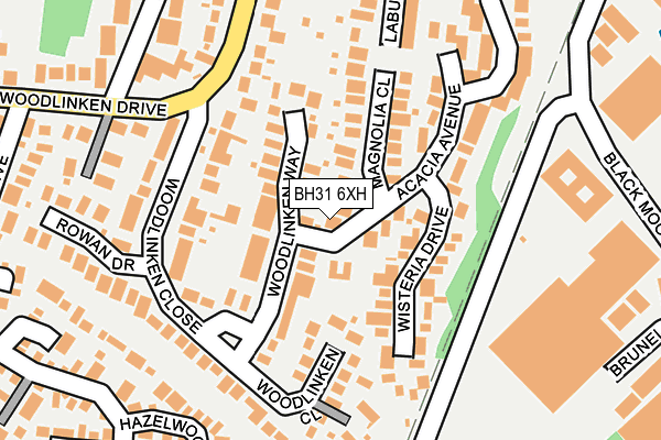
BH31 6XH is located in the Verwood electoral ward, within the unitary authority of Dorset and the English Parliamentary constituency of North Dorset. The Sub Integrated Care Board (ICB) Location is NHS Dorset ICB - 11J and the police force is Dorset. This postcode has been in use since September 1991.


GetTheData
Source: OS OpenMap – Local (Ordnance Survey)
Source: OS VectorMap District (Ordnance Survey)
Licence: Open Government Licence (requires attribution)
| Easting | 410070 |
| Northing | 107866 |
| Latitude | 50.870210 |
| Longitude | -1.858263 |
GetTheData
Source: Open Postcode Geo
Licence: Open Government Licence
| Country | England |
| Postcode District | BH31 |
➜ See where BH31 is on a map ➜ Where is Verwood? | |
GetTheData
Source: Land Registry Price Paid Data
Licence: Open Government Licence
Elevation or altitude of BH31 6XH as distance above sea level:
| Metres | Feet | |
|---|---|---|
| Elevation | 30m | 98ft |
Elevation is measured from the approximate centre of the postcode, to the nearest point on an OS contour line from OS Terrain 50, which has contour spacing of ten vertical metres.
➜ How high above sea level am I? Find the elevation of your current position using your device's GPS.
GetTheData
Source: Open Postcode Elevation
Licence: Open Government Licence
| Ward | Verwood |
| Constituency | North Dorset |
GetTheData
Source: ONS Postcode Database
Licence: Open Government Licence
42, ACACIA AVENUE, VERWOOD, BH31 6XH 2020 21 FEB £325,000 |
44, ACACIA AVENUE, VERWOOD, BH31 6XH 2019 16 AUG £370,000 |
GetTheData
Source: HM Land Registry Price Paid Data
Licence: Contains HM Land Registry data © Crown copyright and database right 2025. This data is licensed under the Open Government Licence v3.0.
| Woodlinken Drive | Verwood | 217m |
| Woodlinken Drive | Verwood | 221m |
| Lake Road (Woodlinken Drive) | Verwood | 405m |
| Lake Road (Woodlinken Drive) | Verwood | 424m |
| Forestside (Ringwood Road) | Ebblake | 463m |
GetTheData
Source: NaPTAN
Licence: Open Government Licence
| Percentage of properties with Next Generation Access | 100.0% |
| Percentage of properties with Superfast Broadband | 100.0% |
| Percentage of properties with Ultrafast Broadband | 0.0% |
| Percentage of properties with Full Fibre Broadband | 0.0% |
Superfast Broadband is between 30Mbps and 300Mbps
Ultrafast Broadband is > 300Mbps
| Percentage of properties unable to receive 2Mbps | 0.0% |
| Percentage of properties unable to receive 5Mbps | 0.0% |
| Percentage of properties unable to receive 10Mbps | 0.0% |
| Percentage of properties unable to receive 30Mbps | 0.0% |
GetTheData
Source: Ofcom
Licence: Ofcom Terms of Use (requires attribution)
GetTheData
Source: ONS Postcode Database
Licence: Open Government Licence


➜ Get more ratings from the Food Standards Agency
GetTheData
Source: Food Standards Agency
Licence: FSA terms & conditions
| Last Collection | |||
|---|---|---|---|
| Location | Mon-Fri | Sat | Distance |
| Woodlinken Drive | 16:00 | 08:15 | 438m |
| Blackmoor Road | 17:00 | 08:00 | 491m |
| Woodlinken Drive | 16:30 | 08:15 | 508m |
GetTheData
Source: Dracos
Licence: Creative Commons Attribution-ShareAlike
The below table lists the International Territorial Level (ITL) codes (formerly Nomenclature of Territorial Units for Statistics (NUTS) codes) and Local Administrative Units (LAU) codes for BH31 6XH:
| ITL 1 Code | Name |
|---|---|
| TLK | South West (England) |
| ITL 2 Code | Name |
| TLK2 | Dorset and Somerset |
| ITL 3 Code | Name |
| TLK25 | Dorset |
| LAU 1 Code | Name |
| E06000059 | Dorset |
GetTheData
Source: ONS Postcode Directory
Licence: Open Government Licence
The below table lists the Census Output Area (OA), Lower Layer Super Output Area (LSOA), and Middle Layer Super Output Area (MSOA) for BH31 6XH:
| Code | Name | |
|---|---|---|
| OA | E00103462 | |
| LSOA | E01020419 | East Dorset 002D |
| MSOA | E02004244 | East Dorset 002 |
GetTheData
Source: ONS Postcode Directory
Licence: Open Government Licence
| BH31 6BT | Woodlinken Way | 60m |
| BH31 6UH | Magnolia Close | 82m |
| BH31 6BP | Woodlinken Close | 90m |
| BH31 6XJ | Wisteria Drive | 109m |
| BH31 6XF | Acacia Avenue | 169m |
| BH31 6BS | Woodlinken Close | 172m |
| BH31 6XG | Acacia Avenue | 202m |
| BH31 6YG | Hazelwood Drive | 235m |
| BH31 6DG | Rowan Drive | 242m |
| BH31 6GD | Potterne Wood Close | 246m |
GetTheData
Source: Open Postcode Geo; Land Registry Price Paid Data
Licence: Open Government Licence