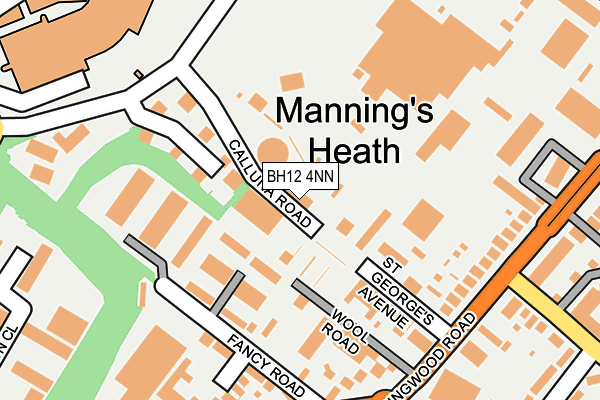
BH12 4NN is located in the Newtown & Heatherlands electoral ward, within the unitary authority of Bournemouth, Christchurch and Poole and the English Parliamentary constituency of Poole. The Sub Integrated Care Board (ICB) Location is NHS Dorset ICB - 11J and the police force is Dorset. This postcode has been in use since December 2000.


GetTheData
Source: OS OpenMap – Local (Ordnance Survey)
Source: OS VectorMap District (Ordnance Survey)
Licence: Open Government Licence (requires attribution)
| Easting | 403682 |
| Northing | 93871 |
| Latitude | 50.744424 |
| Longitude | -1.949172 |
GetTheData
Source: Open Postcode Geo
Licence: Open Government Licence
| Country | England |
| Postcode District | BH12 |
➜ See where BH12 is on a map ➜ Where is Poole? | |
GetTheData
Source: Land Registry Price Paid Data
Licence: Open Government Licence
Elevation or altitude of BH12 4NN as distance above sea level:
| Metres | Feet | |
|---|---|---|
| Elevation | 60m | 197ft |
Elevation is measured from the approximate centre of the postcode, to the nearest point on an OS contour line from OS Terrain 50, which has contour spacing of ten vertical metres.
➜ How high above sea level am I? Find the elevation of your current position using your device's GPS.
GetTheData
Source: Open Postcode Elevation
Licence: Open Government Licence
| Ward | Newtown & Heatherlands |
| Constituency | Poole |
GetTheData
Source: ONS Postcode Database
Licence: Open Government Licence
| Old Wareham Road (Ringwood Road) | Alderney | 230m |
| Chesil Gardens (Rossmore Road) | Newtown | 279m |
| Old Wareham Road (Ringwood Road) | Newtown | 295m |
| Trinidad House (Rossmore Road) | Newtown | 374m |
| Trinidad House (Rossmore Road) | Newtown | 393m |
| Parkstone (Dorset) Station | 2.4km |
| Branksome Station | 2.8km |
| Poole Station | 3.7km |
GetTheData
Source: NaPTAN
Licence: Open Government Licence
GetTheData
Source: ONS Postcode Database
Licence: Open Government Licence

➜ Get more ratings from the Food Standards Agency
GetTheData
Source: Food Standards Agency
Licence: FSA terms & conditions
| Last Collection | |||
|---|---|---|---|
| Location | Mon-Fri | Sat | Distance |
| Ling Road | 18:30 | 12:45 | 162m |
| Ringwood Road | 17:30 | 12:15 | 447m |
| Alderney P.o. | 17:30 | 12:15 | 510m |
GetTheData
Source: Dracos
Licence: Creative Commons Attribution-ShareAlike
The below table lists the International Territorial Level (ITL) codes (formerly Nomenclature of Territorial Units for Statistics (NUTS) codes) and Local Administrative Units (LAU) codes for BH12 4NN:
| ITL 1 Code | Name |
|---|---|
| TLK | South West (England) |
| ITL 2 Code | Name |
| TLK2 | Dorset and Somerset |
| ITL 3 Code | Name |
| TLK24 | Bournemouth, Christchurch and Poole |
| LAU 1 Code | Name |
| E06000058 | Bournemouth, Christchurch and Poole |
GetTheData
Source: ONS Postcode Directory
Licence: Open Government Licence
The below table lists the Census Output Area (OA), Lower Layer Super Output Area (LSOA), and Middle Layer Super Output Area (MSOA) for BH12 4NN:
| Code | Name | |
|---|---|---|
| OA | E00078072 | |
| LSOA | E01015439 | Poole 008B |
| MSOA | E02003201 | Poole 008 |
GetTheData
Source: ONS Postcode Directory
Licence: Open Government Licence
| BH12 4ND | St Georges Avenue | 133m |
| BH12 4NZ | Ling Road | 134m |
| BH12 4QZ | Fancy Road | 146m |
| BH12 4QR | Old Wareham Road | 229m |
| BH12 4QD | Innovation Close | 246m |
| BH12 4QN | Old Wareham Road | 249m |
| BH12 4PY | Ling Road | 271m |
| BH12 4LY | Ringwood Road | 279m |
| BH12 4LS | Ringwood Road | 293m |
| BH12 3NH | Rossmore Road | 327m |
GetTheData
Source: Open Postcode Geo; Land Registry Price Paid Data
Licence: Open Government Licence