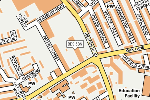
BD9 5BN lies on Lilycroft Road in Bradford. BD9 5BN is located in the Toller electoral ward, within the metropolitan district of Bradford and the English Parliamentary constituency of Bradford West. The Sub Integrated Care Board (ICB) Location is NHS West Yorkshire ICB - 36J and the police force is West Yorkshire. This postcode has been in use since August 2008.


GetTheData
Source: OS OpenMap – Local (Ordnance Survey)
Source: OS VectorMap District (Ordnance Survey)
Licence: Open Government Licence (requires attribution)
| Easting | 414685 |
| Northing | 434723 |
| Latitude | 53.808609 |
| Longitude | -1.778484 |
GetTheData
Source: Open Postcode Geo
Licence: Open Government Licence
| Street | Lilycroft Road |
| Town/City | Bradford |
| Country | England |
| Postcode District | BD9 |
➜ See where BD9 is on a map ➜ Where is Bradford? | |
GetTheData
Source: Land Registry Price Paid Data
Licence: Open Government Licence
Elevation or altitude of BD9 5BN as distance above sea level:
| Metres | Feet | |
|---|---|---|
| Elevation | 170m | 558ft |
Elevation is measured from the approximate centre of the postcode, to the nearest point on an OS contour line from OS Terrain 50, which has contour spacing of ten vertical metres.
➜ How high above sea level am I? Find the elevation of your current position using your device's GPS.
GetTheData
Source: Open Postcode Elevation
Licence: Open Government Licence
| Ward | Toller |
| Constituency | Bradford West |
GetTheData
Source: ONS Postcode Database
Licence: Open Government Licence
APARTMENT 324, THE VELVET MILL, LILYCROFT ROAD, BRADFORD, BD9 5BN 2008 22 OCT £105,000 |
GetTheData
Source: HM Land Registry Price Paid Data
Licence: Contains HM Land Registry data © Crown copyright and database right 2025. This data is licensed under the Open Government Licence v3.0.
| Heaton Road Lilycroft Rd (Heaton Road) | Manningham | 60m |
| Lilycroft Road Police Hq (Lilycroft Road) | Manningham | 74m |
| Oak Ln Victor Terrace (Oak Lane) | Manningham | 151m |
| Heaton Road Westbourne Rd (Heaton Road) | Manningham | 177m |
| Lilycroft Rd Farcliffe Road (Lilycroft Road) | Girlington | 214m |
| Frizinghall Station | 1.5km |
| Bradford Forster Square Station | 2.1km |
| Bradford Interchange Station | 2.7km |
GetTheData
Source: NaPTAN
Licence: Open Government Licence
| Median download speed | 40.0Mbps |
| Average download speed | 46.1Mbps |
| Maximum download speed | 77.81Mbps |
| Median upload speed | 10.0Mbps |
| Average upload speed | 10.1Mbps |
| Maximum upload speed | 20.00Mbps |
GetTheData
Source: Ofcom
Licence: Ofcom Terms of Use (requires attribution)
Estimated total energy consumption in BD9 5BN by fuel type, 2015.
| Consumption (kWh) | 51,715 |
|---|---|
| Meter count | 8 |
| Mean (kWh/meter) | 6,464 |
| Median (kWh/meter) | 5,859 |
GetTheData
Source: Postcode level gas estimates: 2015 (experimental)
Source: Postcode level electricity estimates: 2015 (experimental)
Licence: Open Government Licence
GetTheData
Source: ONS Postcode Database
Licence: Open Government Licence


➜ Get more ratings from the Food Standards Agency
GetTheData
Source: Food Standards Agency
Licence: FSA terms & conditions
| Last Collection | |||
|---|---|---|---|
| Location | Mon-Fri | Sat | Distance |
| Heaton Road | 18:00 | 11:45 | 214m |
| St Marys Road | 18:00 | 11:45 | 519m |
| 86 Carlisle Road | 18:00 | 11:45 | 520m |
GetTheData
Source: Dracos
Licence: Creative Commons Attribution-ShareAlike
The below table lists the International Territorial Level (ITL) codes (formerly Nomenclature of Territorial Units for Statistics (NUTS) codes) and Local Administrative Units (LAU) codes for BD9 5BN:
| ITL 1 Code | Name |
|---|---|
| TLE | Yorkshire and The Humber |
| ITL 2 Code | Name |
| TLE4 | West Yorkshire |
| ITL 3 Code | Name |
| TLE41 | Bradford |
| LAU 1 Code | Name |
| E08000032 | Bradford |
GetTheData
Source: ONS Postcode Directory
Licence: Open Government Licence
The below table lists the Census Output Area (OA), Lower Layer Super Output Area (LSOA), and Middle Layer Super Output Area (MSOA) for BD9 5BN:
| Code | Name | |
|---|---|---|
| OA | E00176122 | |
| LSOA | E01010807 | Bradford 033C |
| MSOA | E02002215 | Bradford 033 |
GetTheData
Source: ONS Postcode Directory
Licence: Open Government Licence
| BD9 5BR | Lilycroft Road | 7m |
| BD9 5BQ | Lilycroft Road | 11m |
| BD9 5BE | Lilycroft Road | 71m |
| BD9 5BD | Lilycroft Road | 72m |
| BD9 4RJ | Heaton Road | 84m |
| BD9 4RH | Victor Terrace | 107m |
| BD9 4RE | Oak Lane | 111m |
| BD9 4RQ | Victor Terrace | 136m |
| BD9 4QR | Victor Road | 156m |
| BD9 4RD | Oak Lane | 171m |
GetTheData
Source: Open Postcode Geo; Land Registry Price Paid Data
Licence: Open Government Licence