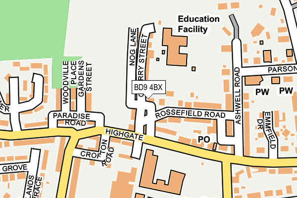
BD9 4BX lies on Back Lane in Heaton, Bradford. BD9 4BX is located in the Heaton electoral ward, within the metropolitan district of Bradford and the English Parliamentary constituency of Bradford West. The Sub Integrated Care Board (ICB) Location is NHS West Yorkshire ICB - 36J and the police force is West Yorkshire. This postcode has been in use since January 1980.


GetTheData
Source: OS OpenMap – Local (Ordnance Survey)
Source: OS VectorMap District (Ordnance Survey)
Licence: Open Government Licence (requires attribution)
| Easting | 414095 |
| Northing | 435609 |
| Latitude | 53.816574 |
| Longitude | -1.787400 |
GetTheData
Source: Open Postcode Geo
Licence: Open Government Licence
| Street | Back Lane |
| Locality | Heaton |
| Town/City | Bradford |
| Country | England |
| Postcode District | BD9 |
➜ See where BD9 is on a map ➜ Where is Bradford? | |
GetTheData
Source: Land Registry Price Paid Data
Licence: Open Government Licence
Elevation or altitude of BD9 4BX as distance above sea level:
| Metres | Feet | |
|---|---|---|
| Elevation | 200m | 656ft |
Elevation is measured from the approximate centre of the postcode, to the nearest point on an OS contour line from OS Terrain 50, which has contour spacing of ten vertical metres.
➜ How high above sea level am I? Find the elevation of your current position using your device's GPS.
GetTheData
Source: Open Postcode Elevation
Licence: Open Government Licence
| Ward | Heaton |
| Constituency | Bradford West |
GetTheData
Source: ONS Postcode Database
Licence: Open Government Licence
| Highgate Quarry Street (Highgate) | Heaton | 94m |
| Highgate Quarry Street (Highgate) | Heaton | 105m |
| Highgate Heaton Road (Highgate) | Heaton | 168m |
| Highgate Heaton Road (Highgate) | Heaton | 186m |
| Ashwell Road Parsons Rd (Ashwell Road) | Heaton | 189m |
| Frizinghall Station | 1.3km |
| Shipley Station | 2km |
| Saltaire Station | 2.4km |
GetTheData
Source: NaPTAN
Licence: Open Government Licence
| Percentage of properties with Next Generation Access | 100.0% |
| Percentage of properties with Superfast Broadband | 100.0% |
| Percentage of properties with Ultrafast Broadband | 50.0% |
| Percentage of properties with Full Fibre Broadband | 0.0% |
Superfast Broadband is between 30Mbps and 300Mbps
Ultrafast Broadband is > 300Mbps
| Percentage of properties unable to receive 2Mbps | 0.0% |
| Percentage of properties unable to receive 5Mbps | 0.0% |
| Percentage of properties unable to receive 10Mbps | 0.0% |
| Percentage of properties unable to receive 30Mbps | 0.0% |
GetTheData
Source: Ofcom
Licence: Ofcom Terms of Use (requires attribution)
GetTheData
Source: ONS Postcode Database
Licence: Open Government Licence


➜ Get more ratings from the Food Standards Agency
GetTheData
Source: Food Standards Agency
Licence: FSA terms & conditions
| Last Collection | |||
|---|---|---|---|
| Location | Mon-Fri | Sat | Distance |
| 110 Leylands Lane | 18:00 | 11:45 | 469m |
| Heaton Road | 18:00 | 11:45 | 1,278m |
| Branch | 17:45 | 12:45 | 1,364m |
GetTheData
Source: Dracos
Licence: Creative Commons Attribution-ShareAlike
The below table lists the International Territorial Level (ITL) codes (formerly Nomenclature of Territorial Units for Statistics (NUTS) codes) and Local Administrative Units (LAU) codes for BD9 4BX:
| ITL 1 Code | Name |
|---|---|
| TLE | Yorkshire and The Humber |
| ITL 2 Code | Name |
| TLE4 | West Yorkshire |
| ITL 3 Code | Name |
| TLE41 | Bradford |
| LAU 1 Code | Name |
| E08000032 | Bradford |
GetTheData
Source: ONS Postcode Directory
Licence: Open Government Licence
The below table lists the Census Output Area (OA), Lower Layer Super Output Area (LSOA), and Middle Layer Super Output Area (MSOA) for BD9 4BX:
| Code | Name | |
|---|---|---|
| OA | E00053878 | |
| LSOA | E01010675 | Bradford 029D |
| MSOA | E02002211 | Bradford 029 |
GetTheData
Source: ONS Postcode Directory
Licence: Open Government Licence
| BD9 4BU | Back Lane | 26m |
| BD9 4BY | Quarry Street | 41m |
| BD9 4DB | Hilda Street | 46m |
| BD9 4BS | Quarry Street | 68m |
| BD9 4BT | Quarry Street | 77m |
| BD9 4DD | Rossefield Road | 90m |
| BD9 4DA | Rossefield Road | 101m |
| BD9 4BE | Highgate | 105m |
| BD9 4BB | Highgate | 110m |
| BD9 4BP | Garden Street | 123m |
GetTheData
Source: Open Postcode Geo; Land Registry Price Paid Data
Licence: Open Government Licence