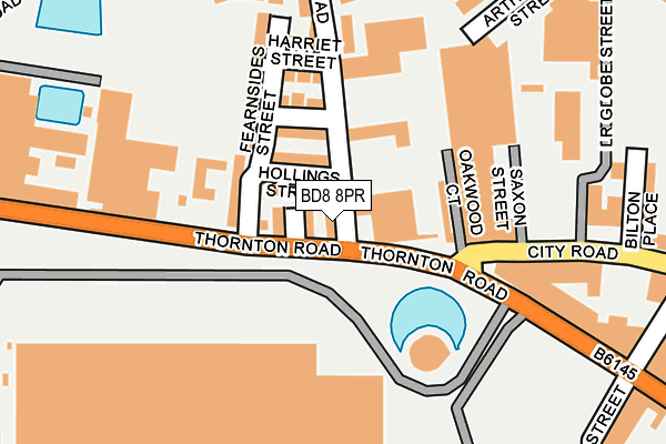
BD8 8PR lies on Hollings Road in Bradford. BD8 8PR is located in the Manningham electoral ward, within the metropolitan district of Bradford and the English Parliamentary constituency of Bradford West. The Sub Integrated Care Board (ICB) Location is NHS West Yorkshire ICB - 36J and the police force is West Yorkshire. This postcode has been in use since January 1980.


GetTheData
Source: OS OpenMap – Local (Ordnance Survey)
Source: OS VectorMap District (Ordnance Survey)
Licence: Open Government Licence (requires attribution)
| Easting | 414985 |
| Northing | 433603 |
| Latitude | 53.798519 |
| Longitude | -1.773979 |
GetTheData
Source: Open Postcode Geo
Licence: Open Government Licence
| Street | Hollings Road |
| Town/City | Bradford |
| Country | England |
| Postcode District | BD8 |
➜ See where BD8 is on a map ➜ Where is Bradford? | |
GetTheData
Source: Land Registry Price Paid Data
Licence: Open Government Licence
Elevation or altitude of BD8 8PR as distance above sea level:
| Metres | Feet | |
|---|---|---|
| Elevation | 120m | 394ft |
Elevation is measured from the approximate centre of the postcode, to the nearest point on an OS contour line from OS Terrain 50, which has contour spacing of ten vertical metres.
➜ How high above sea level am I? Find the elevation of your current position using your device's GPS.
GetTheData
Source: Open Postcode Elevation
Licence: Open Government Licence
| Ward | Manningham |
| Constituency | Bradford West |
GetTheData
Source: ONS Postcode Database
Licence: Open Government Licence
| Thornton Rd Hollings Road (Thornton Road) | Listerhills | 20m |
| Thornton Rd Hollings Road (Thornton Road) | Listerhills | 35m |
| Thornton Rd Fearnside Street (Thornton Road) | Girlington | 214m |
| Thornton Rd Preston Street (Thornton Road) | Listerhills | 214m |
| Thornton Rd Brownroyd Street (Thornton Road) | Girlington | 238m |
| Bradford Forster Square Station | 1.4km |
| Bradford Interchange Station | 1.8km |
| Frizinghall Station | 2.5km |
GetTheData
Source: NaPTAN
Licence: Open Government Licence
| Percentage of properties with Next Generation Access | 100.0% |
| Percentage of properties with Superfast Broadband | 100.0% |
| Percentage of properties with Ultrafast Broadband | 100.0% |
| Percentage of properties with Full Fibre Broadband | 0.0% |
Superfast Broadband is between 30Mbps and 300Mbps
Ultrafast Broadband is > 300Mbps
| Percentage of properties unable to receive 2Mbps | 0.0% |
| Percentage of properties unable to receive 5Mbps | 0.0% |
| Percentage of properties unable to receive 10Mbps | 0.0% |
| Percentage of properties unable to receive 30Mbps | 0.0% |
GetTheData
Source: Ofcom
Licence: Ofcom Terms of Use (requires attribution)
GetTheData
Source: ONS Postcode Database
Licence: Open Government Licence


➜ Get more ratings from the Food Standards Agency
GetTheData
Source: Food Standards Agency
Licence: FSA terms & conditions
| Last Collection | |||
|---|---|---|---|
| Location | Mon-Fri | Sat | Distance |
| Water Lane | 18:30 | 12:45 | 520m |
| Toller Lane | 18:00 | 12:30 | 582m |
| 71 Whetley Lane | 18:00 | 12:30 | 590m |
GetTheData
Source: Dracos
Licence: Creative Commons Attribution-ShareAlike
The below table lists the International Territorial Level (ITL) codes (formerly Nomenclature of Territorial Units for Statistics (NUTS) codes) and Local Administrative Units (LAU) codes for BD8 8PR:
| ITL 1 Code | Name |
|---|---|
| TLE | Yorkshire and The Humber |
| ITL 2 Code | Name |
| TLE4 | West Yorkshire |
| ITL 3 Code | Name |
| TLE41 | Bradford |
| LAU 1 Code | Name |
| E08000032 | Bradford |
GetTheData
Source: ONS Postcode Directory
Licence: Open Government Licence
The below table lists the Census Output Area (OA), Lower Layer Super Output Area (LSOA), and Middle Layer Super Output Area (MSOA) for BD8 8PR:
| Code | Name | |
|---|---|---|
| OA | E00176102 | |
| LSOA | E01010812 | Bradford 041B |
| MSOA | E02002223 | Bradford 041 |
GetTheData
Source: ONS Postcode Directory
Licence: Open Government Licence
| BD8 8LE | Glynn Terrace | 21m |
| BD8 8PP | Hollings Street | 44m |
| BD8 8LD | Thornton Road | 92m |
| BD8 8PW | Fearnsides Terrace | 110m |
| BD8 8PL | Harriet Street | 130m |
| BD8 8JY | City Road | 133m |
| BD8 8PN | Fearnsides Street | 135m |
| BD8 8PU | Juniper Close | 282m |
| BD8 8JS | Bilton Place | 286m |
| BD8 8PF | Hollings Terrace | 288m |
GetTheData
Source: Open Postcode Geo; Land Registry Price Paid Data
Licence: Open Government Licence