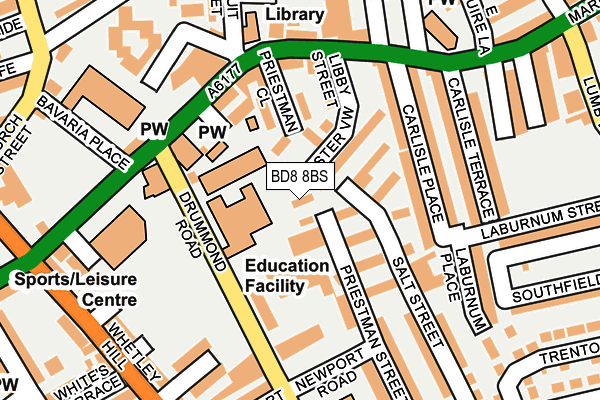
BD8 8BS is located in the Manningham electoral ward, within the metropolitan district of Bradford and the English Parliamentary constituency of Bradford West. The Sub Integrated Care Board (ICB) Location is NHS West Yorkshire ICB - 36J and the police force is West Yorkshire. This postcode has been in use since February 2009.


GetTheData
Source: OS OpenMap – Local (Ordnance Survey)
Source: OS VectorMap District (Ordnance Survey)
Licence: Open Government Licence (requires attribution)
| Easting | 415127 |
| Northing | 434236 |
| Latitude | 53.804204 |
| Longitude | -1.771793 |
GetTheData
Source: Open Postcode Geo
Licence: Open Government Licence
| Country | England |
| Postcode District | BD8 |
➜ See where BD8 is on a map ➜ Where is Bradford? | |
GetTheData
Source: Land Registry Price Paid Data
Licence: Open Government Licence
Elevation or altitude of BD8 8BS as distance above sea level:
| Metres | Feet | |
|---|---|---|
| Elevation | 150m | 492ft |
Elevation is measured from the approximate centre of the postcode, to the nearest point on an OS contour line from OS Terrain 50, which has contour spacing of ten vertical metres.
➜ How high above sea level am I? Find the elevation of your current position using your device's GPS.
GetTheData
Source: Open Postcode Elevation
Licence: Open Government Licence
| Ward | Manningham |
| Constituency | Bradford West |
GetTheData
Source: ONS Postcode Database
Licence: Open Government Licence
| Drummond Middle School Drummond Road (Drummond Road) | Manningham | 99m |
| Carlisle Road Century Place (Carlisle Road) | Manningham | 133m |
| Conduit Street Carlisle Rd (Conduit Street) | Manningham | 192m |
| Carlisle Road Barden St (Carlisle Road) | Girlington | 226m |
| Whetley Hill Atlas Street (Whetley Hill) | Girlington | 244m |
| Bradford Forster Square Station | 1.5km |
| Frizinghall Station | 1.8km |
| Bradford Interchange Station | 2.1km |
GetTheData
Source: NaPTAN
Licence: Open Government Licence
| Percentage of properties with Next Generation Access | 100.0% |
| Percentage of properties with Superfast Broadband | 100.0% |
| Percentage of properties with Ultrafast Broadband | 0.0% |
| Percentage of properties with Full Fibre Broadband | 0.0% |
Superfast Broadband is between 30Mbps and 300Mbps
Ultrafast Broadband is > 300Mbps
| Percentage of properties unable to receive 2Mbps | 0.0% |
| Percentage of properties unable to receive 5Mbps | 0.0% |
| Percentage of properties unable to receive 10Mbps | 0.0% |
| Percentage of properties unable to receive 30Mbps | 0.0% |
GetTheData
Source: Ofcom
Licence: Ofcom Terms of Use (requires attribution)
GetTheData
Source: ONS Postcode Database
Licence: Open Government Licence


➜ Get more ratings from the Food Standards Agency
GetTheData
Source: Food Standards Agency
Licence: FSA terms & conditions
| Last Collection | |||
|---|---|---|---|
| Location | Mon-Fri | Sat | Distance |
| 86 Carlisle Road | 18:00 | 11:45 | 164m |
| Toller Lane | 18:00 | 12:30 | 262m |
| St Marys Road | 18:00 | 11:45 | 330m |
GetTheData
Source: Dracos
Licence: Creative Commons Attribution-ShareAlike
The below table lists the International Territorial Level (ITL) codes (formerly Nomenclature of Territorial Units for Statistics (NUTS) codes) and Local Administrative Units (LAU) codes for BD8 8BS:
| ITL 1 Code | Name |
|---|---|
| TLE | Yorkshire and The Humber |
| ITL 2 Code | Name |
| TLE4 | West Yorkshire |
| ITL 3 Code | Name |
| TLE41 | Bradford |
| LAU 1 Code | Name |
| E08000032 | Bradford |
GetTheData
Source: ONS Postcode Directory
Licence: Open Government Licence
The below table lists the Census Output Area (OA), Lower Layer Super Output Area (LSOA), and Middle Layer Super Output Area (MSOA) for BD8 8BS:
| Code | Name | |
|---|---|---|
| OA | E00054652 | |
| LSOA | E01010840 | Bradford 034D |
| MSOA | E02002216 | Bradford 034 |
GetTheData
Source: ONS Postcode Directory
Licence: Open Government Licence
| BD8 8DJ | Lister View | 58m |
| BD8 8BH | Salt Street | 85m |
| BD8 8BG | Salt Street | 88m |
| BD8 8DN | Priestman Close | 92m |
| BD8 8AZ | Carlisle Place | 114m |
| BD8 8BY | Carlisle Road | 126m |
| BD8 8BE | Carlisle Road | 138m |
| BD8 8AU | Laburnum Place | 140m |
| BD8 8AY | Carlisle Place | 142m |
| BD8 8AX | Carlisle Terrace | 163m |
GetTheData
Source: Open Postcode Geo; Land Registry Price Paid Data
Licence: Open Government Licence