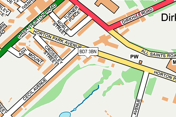
BD7 3BN is located in the City electoral ward, within the metropolitan district of Bradford and the English Parliamentary constituency of Bradford West. The Sub Integrated Care Board (ICB) Location is NHS West Yorkshire ICB - 36J and the police force is West Yorkshire. This postcode has been in use since January 1980.


GetTheData
Source: OS OpenMap – Local (Ordnance Survey)
Source: OS VectorMap District (Ordnance Survey)
Licence: Open Government Licence (requires attribution)
| Easting | 415012 |
| Northing | 432056 |
| Latitude | 53.784614 |
| Longitude | -1.773644 |
GetTheData
Source: Open Postcode Geo
Licence: Open Government Licence
| Country | England |
| Postcode District | BD7 |
➜ See where BD7 is on a map ➜ Where is Bradford? | |
GetTheData
Source: Land Registry Price Paid Data
Licence: Open Government Licence
Elevation or altitude of BD7 3BN as distance above sea level:
| Metres | Feet | |
|---|---|---|
| Elevation | 150m | 492ft |
Elevation is measured from the approximate centre of the postcode, to the nearest point on an OS contour line from OS Terrain 50, which has contour spacing of ten vertical metres.
➜ How high above sea level am I? Find the elevation of your current position using your device's GPS.
GetTheData
Source: Open Postcode Elevation
Licence: Open Government Licence
| Ward | City |
| Constituency | Bradford West |
GetTheData
Source: ONS Postcode Database
Licence: Open Government Licence
| Horton Park Avenue Horton Park Centre (Horton Park Avenue) | Shearbridge | 59m |
| Horton Park Avenue Horton Park Centre (Horton Park Avenue) | Shearbridge | 90m |
| Dirkhill Road All Saints Rd (Dirkhill Road) | Shearbridge | 158m |
| Horton Park Avenue Crossley St (Horton Park Avenue) | Great Horton | 160m |
| Horton Park Ave Great Horton Road (Horton Park Avenue) | Great Horton | 194m |
| Bradford Interchange Station | 1.7km |
| Bradford Forster Square Station | 1.9km |
| Frizinghall Station | 4km |
GetTheData
Source: NaPTAN
Licence: Open Government Licence
GetTheData
Source: ONS Postcode Database
Licence: Open Government Licence


➜ Get more ratings from the Food Standards Agency
GetTheData
Source: Food Standards Agency
Licence: FSA terms & conditions
| Last Collection | |||
|---|---|---|---|
| Location | Mon-Fri | Sat | Distance |
| 455 Great Horton Road | 17:45 | 12:45 | 229m |
| 1 Oulton Terrace | 18:30 | 12:15 | 489m |
| Laisteridge Lane | 18:00 | 11:45 | 492m |
GetTheData
Source: Dracos
Licence: Creative Commons Attribution-ShareAlike
The below table lists the International Territorial Level (ITL) codes (formerly Nomenclature of Territorial Units for Statistics (NUTS) codes) and Local Administrative Units (LAU) codes for BD7 3BN:
| ITL 1 Code | Name |
|---|---|
| TLE | Yorkshire and The Humber |
| ITL 2 Code | Name |
| TLE4 | West Yorkshire |
| ITL 3 Code | Name |
| TLE41 | Bradford |
| LAU 1 Code | Name |
| E08000032 | Bradford |
GetTheData
Source: ONS Postcode Directory
Licence: Open Government Licence
The below table lists the Census Output Area (OA), Lower Layer Super Output Area (LSOA), and Middle Layer Super Output Area (MSOA) for BD7 3BN:
| Code | Name | |
|---|---|---|
| OA | E00054643 | |
| LSOA | E01010839 | Bradford 044F |
| MSOA | E02002226 | Bradford 044 |
GetTheData
Source: ONS Postcode Directory
Licence: Open Government Licence
| BD7 3BP | Cecil Avenue | 111m |
| BD7 3BL | Horton Park Avenue | 128m |
| BD7 3BB | Dirkhill Street | 129m |
| BD7 3AY | All Saints Road | 138m |
| BD7 3BJ | Crossley Street | 154m |
| BD7 3BE | Turner Place | 156m |
| BD7 3BD | Noble Street | 158m |
| BD7 3BW | Cecil Avenue | 178m |
| BD7 3BH | Ashmount | 179m |
| BD7 1QP | Dirkhill Road | 182m |
GetTheData
Source: Open Postcode Geo; Land Registry Price Paid Data
Licence: Open Government Licence