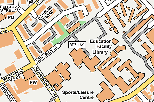
BD7 1AY is located in the City electoral ward, within the metropolitan district of Bradford and the English Parliamentary constituency of Bradford West. The Sub Integrated Care Board (ICB) Location is NHS West Yorkshire ICB - 36J and the police force is West Yorkshire. This postcode has been in use since January 1980.


GetTheData
Source: OS OpenMap – Local (Ordnance Survey)
Source: OS VectorMap District (Ordnance Survey)
Licence: Open Government Licence (requires attribution)
| Easting | 415374 |
| Northing | 432843 |
| Latitude | 53.791677 |
| Longitude | -1.768111 |
GetTheData
Source: Open Postcode Geo
Licence: Open Government Licence
| Country | England |
| Postcode District | BD7 |
➜ See where BD7 is on a map ➜ Where is Bradford? | |
GetTheData
Source: Land Registry Price Paid Data
Licence: Open Government Licence
Elevation or altitude of BD7 1AY as distance above sea level:
| Metres | Feet | |
|---|---|---|
| Elevation | 120m | 394ft |
Elevation is measured from the approximate centre of the postcode, to the nearest point on an OS contour line from OS Terrain 50, which has contour spacing of ten vertical metres.
➜ How high above sea level am I? Find the elevation of your current position using your device's GPS.
GetTheData
Source: Open Postcode Elevation
Licence: Open Government Licence
| Ward | City |
| Constituency | Bradford West |
GetTheData
Source: ONS Postcode Database
Licence: Open Government Licence
| Great Horton Rd Laisteridge Lane (Great Horton Road) | Shearbridge | 231m |
| Listerhills Road St Andrews Place (Listerhills Road) | Listerhills | 241m |
| Great Horton Rd Laisteridge Lane (Great Horton Road) | Shearbridge | 249m |
| Listerhills Rd Morpeth Street (Listerhills Road) | Listerhills | 263m |
| Listerhills Rd Norcroft Street (Listerhills Road) | Listerhills | 281m |
| Bradford Forster Square Station | 1.2km |
| Bradford Interchange Station | 1.2km |
| Frizinghall Station | 3.2km |
GetTheData
Source: NaPTAN
Licence: Open Government Licence
GetTheData
Source: ONS Postcode Database
Licence: Open Government Licence


➜ Get more ratings from the Food Standards Agency
GetTheData
Source: Food Standards Agency
Licence: FSA terms & conditions
| Last Collection | |||
|---|---|---|---|
| Location | Mon-Fri | Sat | Distance |
| Campus Road Business Box | 18:30 | 12:15 | 194m |
| Claremont | 18:30 | 12:15 | 258m |
| Fieldhead Business Park | 18:30 | 12:30 | 278m |
GetTheData
Source: Dracos
Licence: Creative Commons Attribution-ShareAlike
The below table lists the International Territorial Level (ITL) codes (formerly Nomenclature of Territorial Units for Statistics (NUTS) codes) and Local Administrative Units (LAU) codes for BD7 1AY:
| ITL 1 Code | Name |
|---|---|
| TLE | Yorkshire and The Humber |
| ITL 2 Code | Name |
| TLE4 | West Yorkshire |
| ITL 3 Code | Name |
| TLE41 | Bradford |
| LAU 1 Code | Name |
| E08000032 | Bradford |
GetTheData
Source: ONS Postcode Directory
Licence: Open Government Licence
The below table lists the Census Output Area (OA), Lower Layer Super Output Area (LSOA), and Middle Layer Super Output Area (MSOA) for BD7 1AY:
| Code | Name | |
|---|---|---|
| OA | E00054628 | |
| LSOA | E01010834 | Bradford 044A |
| MSOA | E02002226 | Bradford 044 |
GetTheData
Source: ONS Postcode Directory
Licence: Open Government Licence
| BD7 1SA | Longside Lane | 120m |
| BD7 1PP | Great Horton Road | 257m |
| BD7 1DL | Richmond Road | 264m |
| BD7 1PS | Great Horton Road | 272m |
| BD7 1JR | Listerhills Road | 275m |
| BD7 1JS | Morpeth Street | 281m |
| BD7 1HZ | Listerhills Road | 284m |
| BD7 1PH | Great Horton Road | 284m |
| BD7 1RD | Laisteridge Lane | 292m |
| BD7 1DQ | Hey Street | 305m |
GetTheData
Source: Open Postcode Geo; Land Registry Price Paid Data
Licence: Open Government Licence