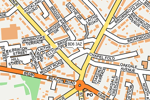
BD6 3AZ lies on Mount Road in Wibsey, Bradford. BD6 3AZ is located in the Wibsey electoral ward, within the metropolitan district of Bradford and the English Parliamentary constituency of Bradford South. The Sub Integrated Care Board (ICB) Location is NHS West Yorkshire ICB - 36J and the police force is West Yorkshire. This postcode has been in use since January 1980.


GetTheData
Source: OS OpenMap – Local (Ordnance Survey)
Source: OS VectorMap District (Ordnance Survey)
Licence: Open Government Licence (requires attribution)
| Easting | 414510 |
| Northing | 430317 |
| Latitude | 53.768998 |
| Longitude | -1.781344 |
GetTheData
Source: Open Postcode Geo
Licence: Open Government Licence
| Street | Mount Road |
| Locality | Wibsey |
| Town/City | Bradford |
| Country | England |
| Postcode District | BD6 |
➜ See where BD6 is on a map ➜ Where is Bradford? | |
GetTheData
Source: Land Registry Price Paid Data
Licence: Open Government Licence
Elevation or altitude of BD6 3AZ as distance above sea level:
| Metres | Feet | |
|---|---|---|
| Elevation | 260m | 853ft |
Elevation is measured from the approximate centre of the postcode, to the nearest point on an OS contour line from OS Terrain 50, which has contour spacing of ten vertical metres.
➜ How high above sea level am I? Find the elevation of your current position using your device's GPS.
GetTheData
Source: Open Postcode Elevation
Licence: Open Government Licence
| Ward | Wibsey |
| Constituency | Bradford South |
GetTheData
Source: ONS Postcode Database
Licence: Open Government Licence
| Moore Avenue Moore Rd (Moore Avenue) | Wibsey | 57m |
| St Enochs Rd Moore Avenue (St Enoch's Road) | Wibsey | 62m |
| Moore Avenue Mount Rd (Moore Avenue) | Wibsey | 82m |
| St Enochs Rd Oakdale Avenue (St Enoch's Road) | Wibsey | 84m |
| Beacon Road St Enochs Rd (Beacon Road) | Wibsey | 126m |
| Low Moor Station | 2.8km |
| Bradford Interchange Station | 3.2km |
| Bradford Forster Square Station | 3.6km |
GetTheData
Source: NaPTAN
Licence: Open Government Licence
| Percentage of properties with Next Generation Access | 100.0% |
| Percentage of properties with Superfast Broadband | 100.0% |
| Percentage of properties with Ultrafast Broadband | 100.0% |
| Percentage of properties with Full Fibre Broadband | 0.0% |
Superfast Broadband is between 30Mbps and 300Mbps
Ultrafast Broadband is > 300Mbps
| Percentage of properties unable to receive 2Mbps | 0.0% |
| Percentage of properties unable to receive 5Mbps | 0.0% |
| Percentage of properties unable to receive 10Mbps | 0.0% |
| Percentage of properties unable to receive 30Mbps | 0.0% |
GetTheData
Source: Ofcom
Licence: Ofcom Terms of Use (requires attribution)
GetTheData
Source: ONS Postcode Database
Licence: Open Government Licence


➜ Get more ratings from the Food Standards Agency
GetTheData
Source: Food Standards Agency
Licence: FSA terms & conditions
| Last Collection | |||
|---|---|---|---|
| Location | Mon-Fri | Sat | Distance |
| Wibsey P.o. Box | 18:30 | 10:15 | 102m |
| Southfield Lane P.o. Box | 17:00 | 12:15 | 960m |
| 39 Shelf Moor Road | 17:15 | 11:00 | 1,137m |
GetTheData
Source: Dracos
Licence: Creative Commons Attribution-ShareAlike
The below table lists the International Territorial Level (ITL) codes (formerly Nomenclature of Territorial Units for Statistics (NUTS) codes) and Local Administrative Units (LAU) codes for BD6 3AZ:
| ITL 1 Code | Name |
|---|---|
| TLE | Yorkshire and The Humber |
| ITL 2 Code | Name |
| TLE4 | West Yorkshire |
| ITL 3 Code | Name |
| TLE41 | Bradford |
| LAU 1 Code | Name |
| E08000032 | Bradford |
GetTheData
Source: ONS Postcode Directory
Licence: Open Government Licence
The below table lists the Census Output Area (OA), Lower Layer Super Output Area (LSOA), and Middle Layer Super Output Area (MSOA) for BD6 3AZ:
| Code | Name | |
|---|---|---|
| OA | E00054685 | |
| LSOA | E01010847 | Bradford 054A |
| MSOA | E02002236 | Bradford 054 |
GetTheData
Source: ONS Postcode Directory
Licence: Open Government Licence
| BD6 3HH | Moore Avenue | 27m |
| BD6 3BX | Fletcher Road | 50m |
| BD6 3AX | Briggs Place | 72m |
| BD6 3BN | Laithe Road | 82m |
| BD6 3BU | St Enochs Road | 91m |
| BD6 3AY | Briggs Avenue | 97m |
| BD6 3AB | St Enochs Road | 100m |
| BD6 3AA | St Enochs Road | 102m |
| BD6 3BT | St Enochs Road | 106m |
| BD6 3BA | Mount Road | 116m |
GetTheData
Source: Open Postcode Geo; Land Registry Price Paid Data
Licence: Open Government Licence