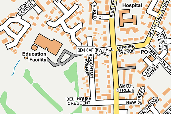
BD4 6AF is located in the Tong electoral ward, within the metropolitan district of Bradford and the English Parliamentary constituency of Bradford South. The Sub Integrated Care Board (ICB) Location is NHS West Yorkshire ICB - 36J and the police force is West Yorkshire. This postcode has been in use since January 1980.


GetTheData
Source: OS OpenMap – Local (Ordnance Survey)
Source: OS VectorMap District (Ordnance Survey)
Licence: Open Government Licence (requires attribution)
| Easting | 417501 |
| Northing | 430127 |
| Latitude | 53.767214 |
| Longitude | -1.735981 |
GetTheData
Source: Open Postcode Geo
Licence: Open Government Licence
| Country | England |
| Postcode District | BD4 |
➜ See where BD4 is on a map ➜ Where is Bradford? | |
GetTheData
Source: Land Registry Price Paid Data
Licence: Open Government Licence
Elevation or altitude of BD4 6AF as distance above sea level:
| Metres | Feet | |
|---|---|---|
| Elevation | 190m | 623ft |
Elevation is measured from the approximate centre of the postcode, to the nearest point on an OS contour line from OS Terrain 50, which has contour spacing of ten vertical metres.
➜ How high above sea level am I? Find the elevation of your current position using your device's GPS.
GetTheData
Source: Open Postcode Elevation
Licence: Open Government Licence
| Ward | Tong |
| Constituency | Bradford South |
GetTheData
Source: ONS Postcode Database
Licence: Open Government Licence
| Bierley Lane Currer Ave (Bierley Lane) | Bierley | 236m |
| Rooley Lane Croft Leigh Court (Rooley Lane) | Bierley | 249m |
| Bierley Lane Midgley Row (Bierley Lane) | Bierley | 266m |
| Rooley Lane Sangster Wy (Rooley Lane) | Bierley | 268m |
| Church Rooley Lane (Rooley Lane) | Bierley | 373m |
| Low Moor Station | 2.2km |
| Bradford Interchange Station | 2.8km |
| Bradford Forster Square Station | 3.5km |
GetTheData
Source: NaPTAN
Licence: Open Government Licence
GetTheData
Source: ONS Postcode Database
Licence: Open Government Licence


➜ Get more ratings from the Food Standards Agency
GetTheData
Source: Food Standards Agency
Licence: FSA terms & conditions
| Last Collection | |||
|---|---|---|---|
| Location | Mon-Fri | Sat | Distance |
| Bierley P.o. Box | 18:15 | 12:00 | 369m |
| Bierley Church | 18:15 | 13:15 | 385m |
| 195 Bierley Lane | 18:00 | 13:00 | 666m |
GetTheData
Source: Dracos
Licence: Creative Commons Attribution-ShareAlike
The below table lists the International Territorial Level (ITL) codes (formerly Nomenclature of Territorial Units for Statistics (NUTS) codes) and Local Administrative Units (LAU) codes for BD4 6AF:
| ITL 1 Code | Name |
|---|---|
| TLE | Yorkshire and The Humber |
| ITL 2 Code | Name |
| TLE4 | West Yorkshire |
| ITL 3 Code | Name |
| TLE41 | Bradford |
| LAU 1 Code | Name |
| E08000032 | Bradford |
GetTheData
Source: ONS Postcode Directory
Licence: Open Government Licence
The below table lists the Census Output Area (OA), Lower Layer Super Output Area (LSOA), and Middle Layer Super Output Area (MSOA) for BD4 6AF:
| Code | Name | |
|---|---|---|
| OA | E00054532 | |
| LSOA | E01010818 | Bradford 057E |
| MSOA | E02002239 | Bradford 057 |
GetTheData
Source: ONS Postcode Directory
Licence: Open Government Licence
| BD5 8AA | Hopefield Way | 102m |
| BD5 8FB | The Fairway | 128m |
| BD5 8DU | Newhall Gardens | 137m |
| BD5 8BR | Newhall Park Drive | 141m |
| BD4 6AE | Newhall Road | 174m |
| BD4 6AH | Broughton Avenue | 195m |
| BD4 6AQ | Alred Court | 203m |
| BD5 8AE | Bannockburn Court | 207m |
| BD4 6AS | Bierley Lane | 242m |
| BD5 8AP | Ridings Croft | 244m |
GetTheData
Source: Open Postcode Geo; Land Registry Price Paid Data
Licence: Open Government Licence