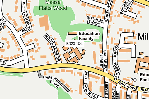
BD23 1QL is located in the Skipton North & Embsay-with-Eastby electoral ward, within the unitary authority of North Yorkshire and the English Parliamentary constituency of Skipton and Ripon. The Sub Integrated Care Board (ICB) Location is NHS West Yorkshire ICB - 36J and the police force is North Yorkshire. This postcode has been in use since January 1980.


GetTheData
Source: OS OpenMap – Local (Ordnance Survey)
Source: OS VectorMap District (Ordnance Survey)
Licence: Open Government Licence (requires attribution)
| Easting | 398304 |
| Northing | 451970 |
| Latitude | 53.963808 |
| Longitude | -2.027338 |
GetTheData
Source: Open Postcode Geo
Licence: Open Government Licence
| Country | England |
| Postcode District | BD23 |
➜ See where BD23 is on a map ➜ Where is Skipton? | |
GetTheData
Source: Land Registry Price Paid Data
Licence: Open Government Licence
Elevation or altitude of BD23 1QL as distance above sea level:
| Metres | Feet | |
|---|---|---|
| Elevation | 120m | 394ft |
Elevation is measured from the approximate centre of the postcode, to the nearest point on an OS contour line from OS Terrain 50, which has contour spacing of ten vertical metres.
➜ How high above sea level am I? Find the elevation of your current position using your device's GPS.
GetTheData
Source: Open Postcode Elevation
Licence: Open Government Licence
| Ward | Skipton North & Embsay-with-eastby |
| Constituency | Skipton And Ripon |
GetTheData
Source: ONS Postcode Database
Licence: Open Government Licence
| Girls High School (Gargrave Road) | Skipton | 74m |
| Woodlands Drive (Gargrave Road) | Skipton | 109m |
| Woodlands Drive (Gargrave Road) | Skipton | 117m |
| Raikeswood (Gargrave Road) | Skipton | 196m |
| Raikeswood (Gargrave Road) | Skipton | 213m |
| Skipton Station | 0.6km |
GetTheData
Source: NaPTAN
Licence: Open Government Licence
Estimated total energy consumption in BD23 1QL by fuel type, 2015.
| Consumption (kWh) | 192,802 |
|---|---|
| Meter count | 6 |
| Mean (kWh/meter) | 32,134 |
| Median (kWh/meter) | 26,831 |
GetTheData
Source: Postcode level gas estimates: 2015 (experimental)
Source: Postcode level electricity estimates: 2015 (experimental)
Licence: Open Government Licence
GetTheData
Source: ONS Postcode Database
Licence: Open Government Licence


➜ Get more ratings from the Food Standards Agency
GetTheData
Source: Food Standards Agency
Licence: FSA terms & conditions
| Last Collection | |||
|---|---|---|---|
| Location | Mon-Fri | Sat | Distance |
| Rockwood Drive | 17:30 | 12:15 | 214m |
| 12 Gargrave Road | 17:30 | 12:15 | 275m |
| Raikes Road | 17:30 | 12:30 | 313m |
GetTheData
Source: Dracos
Licence: Creative Commons Attribution-ShareAlike
The below table lists the International Territorial Level (ITL) codes (formerly Nomenclature of Territorial Units for Statistics (NUTS) codes) and Local Administrative Units (LAU) codes for BD23 1QL:
| ITL 1 Code | Name |
|---|---|
| TLE | Yorkshire and The Humber |
| ITL 2 Code | Name |
| TLE2 | North Yorkshire |
| ITL 3 Code | Name |
| TLE22 | North Yorkshire CC |
| LAU 1 Code | Name |
| E07000163 | Craven |
GetTheData
Source: ONS Postcode Directory
Licence: Open Government Licence
The below table lists the Census Output Area (OA), Lower Layer Super Output Area (LSOA), and Middle Layer Super Output Area (MSOA) for BD23 1QL:
| Code | Name | |
|---|---|---|
| OA | E00140385 | |
| LSOA | E01027576 | Craven 004C |
| MSOA | E02005745 | Craven 004 |
GetTheData
Source: ONS Postcode Directory
Licence: Open Government Licence
| BD23 1QP | Ashgrove | 86m |
| BD23 1QN | Gargrave Road | 99m |
| BD23 1QJ | Gargrave Road | 112m |
| BD23 1QR | Harewood Road | 137m |
| BD23 1NQ | Salisbury Street | 141m |
| BD23 1QU | Woodlands Drive | 147m |
| BD23 1UG | Rockwood Close | 153m |
| BD23 1NE | Botheby Wood | 157m |
| BD23 1QT | West Bank Road | 170m |
| BD23 1NB | Raikeswood Road | 195m |
GetTheData
Source: Open Postcode Geo; Land Registry Price Paid Data
Licence: Open Government Licence