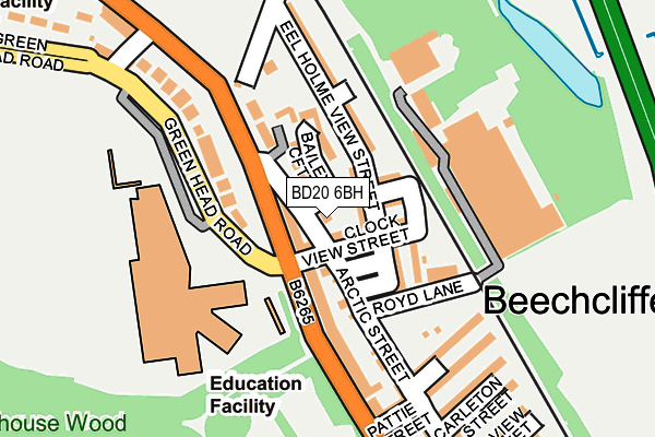
BD20 6BH lies on Arctic Street in Keighley. BD20 6BH is located in the Keighley Central electoral ward, within the metropolitan district of Bradford and the English Parliamentary constituency of Keighley. The Sub Integrated Care Board (ICB) Location is NHS West Yorkshire ICB - 36J and the police force is West Yorkshire. This postcode has been in use since January 1980.


GetTheData
Source: OS OpenMap – Local (Ordnance Survey)
Source: OS VectorMap District (Ordnance Survey)
Licence: Open Government Licence (requires attribution)
| Easting | 405863 |
| Northing | 442533 |
| Latitude | 53.878962 |
| Longitude | -1.912302 |
GetTheData
Source: Open Postcode Geo
Licence: Open Government Licence
| Street | Arctic Street |
| Town/City | Keighley |
| Country | England |
| Postcode District | BD20 |
➜ See where BD20 is on a map ➜ Where is Keighley? | |
GetTheData
Source: Land Registry Price Paid Data
Licence: Open Government Licence
Elevation or altitude of BD20 6BH as distance above sea level:
| Metres | Feet | |
|---|---|---|
| Elevation | 100m | 328ft |
Elevation is measured from the approximate centre of the postcode, to the nearest point on an OS contour line from OS Terrain 50, which has contour spacing of ten vertical metres.
➜ How high above sea level am I? Find the elevation of your current position using your device's GPS.
GetTheData
Source: Open Postcode Elevation
Licence: Open Government Licence
| Ward | Keighley Central |
| Constituency | Keighley |
GetTheData
Source: ONS Postcode Database
Licence: Open Government Licence
| Skipton Rd Green Head Road (Skipton Road) | Utley | 89m |
| Skipton Rd Pattie Street (Skipton Road) | Utley | 168m |
| Greenhead High School (Greenhead Road) | Utley | 204m |
| Skipton Rd Stoneycroft Lane (Skipton Road) | Utley | 227m |
| Skipton Rd Stoneycroft Lane (Skipton Road) | Utley | 246m |
| Keighley Station | 1.4km |
| Steeton & Silsden Station | 3.2km |
| Crossflatts Station | 5km |
GetTheData
Source: NaPTAN
Licence: Open Government Licence
| Percentage of properties with Next Generation Access | 100.0% |
| Percentage of properties with Superfast Broadband | 100.0% |
| Percentage of properties with Ultrafast Broadband | 100.0% |
| Percentage of properties with Full Fibre Broadband | 0.0% |
Superfast Broadband is between 30Mbps and 300Mbps
Ultrafast Broadband is > 300Mbps
| Percentage of properties unable to receive 2Mbps | 0.0% |
| Percentage of properties unable to receive 5Mbps | 0.0% |
| Percentage of properties unable to receive 10Mbps | 0.0% |
| Percentage of properties unable to receive 30Mbps | 0.0% |
GetTheData
Source: Ofcom
Licence: Ofcom Terms of Use (requires attribution)
GetTheData
Source: ONS Postcode Database
Licence: Open Government Licence


➜ Get more ratings from the Food Standards Agency
GetTheData
Source: Food Standards Agency
Licence: FSA terms & conditions
| Last Collection | |||
|---|---|---|---|
| Location | Mon-Fri | Sat | Distance |
| East Ave | 18:00 | 12:15 | 653m |
| Lawksholme Lane | 17:45 | 11:15 | 895m |
| 5 Sandywood Street | 18:00 | 12:15 | 992m |
GetTheData
Source: Dracos
Licence: Creative Commons Attribution-ShareAlike
The below table lists the International Territorial Level (ITL) codes (formerly Nomenclature of Territorial Units for Statistics (NUTS) codes) and Local Administrative Units (LAU) codes for BD20 6BH:
| ITL 1 Code | Name |
|---|---|
| TLE | Yorkshire and The Humber |
| ITL 2 Code | Name |
| TLE4 | West Yorkshire |
| ITL 3 Code | Name |
| TLE41 | Bradford |
| LAU 1 Code | Name |
| E08000032 | Bradford |
GetTheData
Source: ONS Postcode Directory
Licence: Open Government Licence
The below table lists the Census Output Area (OA), Lower Layer Super Output Area (LSOA), and Middle Layer Super Output Area (MSOA) for BD20 6BH:
| Code | Name | |
|---|---|---|
| OA | E00054112 | |
| LSOA | E01010727 | Bradford 007B |
| MSOA | E02002189 | Bradford 007 |
GetTheData
Source: ONS Postcode Directory
Licence: Open Government Licence
| BD20 6AT | Skipton Road | 31m |
| BD20 6BB | Clock View Street | 34m |
| BD20 6BT | Baileys Croft | 48m |
| BD20 6BG | Wignall Street | 49m |
| BD20 6BE | Burton Street | 67m |
| BD20 6BA | Elsie Street | 67m |
| BD20 6AR | Arctic Street | 79m |
| BD20 6BD | Eel Holme View Street | 79m |
| BD20 6AW | Badgers Drift | 91m |
| BD20 6AY | Eel Holme View Street | 98m |
GetTheData
Source: Open Postcode Geo; Land Registry Price Paid Data
Licence: Open Government Licence