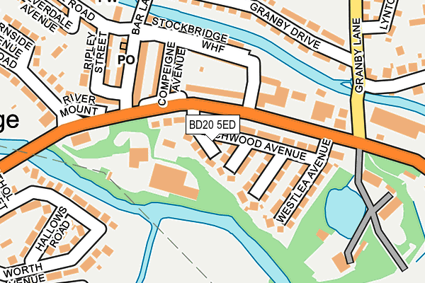
BD20 5ED lies on Beechwood Avenue in Riddlesden, Keighley. BD20 5ED is located in the Keighley East electoral ward, within the metropolitan district of Bradford and the English Parliamentary constituency of Keighley. The Sub Integrated Care Board (ICB) Location is NHS West Yorkshire ICB - 36J and the police force is West Yorkshire. This postcode has been in use since January 1980.


GetTheData
Source: OS OpenMap – Local (Ordnance Survey)
Source: OS VectorMap District (Ordnance Survey)
Licence: Open Government Licence (requires attribution)
| Easting | 407714 |
| Northing | 442238 |
| Latitude | 53.876286 |
| Longitude | -1.884154 |
GetTheData
Source: Open Postcode Geo
Licence: Open Government Licence
| Street | Beechwood Avenue |
| Locality | Riddlesden |
| Town/City | Keighley |
| Country | England |
| Postcode District | BD20 |
➜ See where BD20 is on a map ➜ Where is Keighley? | |
GetTheData
Source: Land Registry Price Paid Data
Licence: Open Government Licence
Elevation or altitude of BD20 5ED as distance above sea level:
| Metres | Feet | |
|---|---|---|
| Elevation | 90m | 295ft |
Elevation is measured from the approximate centre of the postcode, to the nearest point on an OS contour line from OS Terrain 50, which has contour spacing of ten vertical metres.
➜ How high above sea level am I? Find the elevation of your current position using your device's GPS.
GetTheData
Source: Open Postcode Elevation
Licence: Open Government Licence
| Ward | Keighley East |
| Constituency | Keighley |
GetTheData
Source: ONS Postcode Database
Licence: Open Government Licence
| Bradford Road Bar Ln (Bradford Road) | Riddlesden | 89m |
| Bradford Road Bar Ln (Bradford Road) | Riddlesden | 107m |
| Bradford Road West Lea Ave (Bradford Road) | Riddlesden | 147m |
| Bradford Road West Lea Ave (Bradford Road) | Riddlesden | 149m |
| Grange Rd Bradford Road (Grange Road) | Stockbridge | 201m |
| Keighley Station | 1.5km |
| Crossflatts Station | 3.3km |
| Bingley Station | 4.4km |
GetTheData
Source: NaPTAN
Licence: Open Government Licence
| Percentage of properties with Next Generation Access | 100.0% |
| Percentage of properties with Superfast Broadband | 100.0% |
| Percentage of properties with Ultrafast Broadband | 100.0% |
| Percentage of properties with Full Fibre Broadband | 0.0% |
Superfast Broadband is between 30Mbps and 300Mbps
Ultrafast Broadband is > 300Mbps
| Percentage of properties unable to receive 2Mbps | 0.0% |
| Percentage of properties unable to receive 5Mbps | 0.0% |
| Percentage of properties unable to receive 10Mbps | 0.0% |
| Percentage of properties unable to receive 30Mbps | 0.0% |
GetTheData
Source: Ofcom
Licence: Ofcom Terms of Use (requires attribution)
GetTheData
Source: ONS Postcode Database
Licence: Open Government Licence


➜ Get more ratings from the Food Standards Agency
GetTheData
Source: Food Standards Agency
Licence: FSA terms & conditions
| Last Collection | |||
|---|---|---|---|
| Location | Mon-Fri | Sat | Distance |
| Granby Lane | 17:45 | 12:30 | 197m |
| 5 Low Banks Riddlesden | 17:45 | 12:30 | 331m |
| Bradford Road P.o. Box | 17:45 | 12:15 | 493m |
GetTheData
Source: Dracos
Licence: Creative Commons Attribution-ShareAlike
The below table lists the International Territorial Level (ITL) codes (formerly Nomenclature of Territorial Units for Statistics (NUTS) codes) and Local Administrative Units (LAU) codes for BD20 5ED:
| ITL 1 Code | Name |
|---|---|
| TLE | Yorkshire and The Humber |
| ITL 2 Code | Name |
| TLE4 | West Yorkshire |
| ITL 3 Code | Name |
| TLE41 | Bradford |
| LAU 1 Code | Name |
| E08000032 | Bradford |
GetTheData
Source: ONS Postcode Directory
Licence: Open Government Licence
The below table lists the Census Output Area (OA), Lower Layer Super Output Area (LSOA), and Middle Layer Super Output Area (MSOA) for BD20 5ED:
| Code | Name | |
|---|---|---|
| OA | E00053986 | |
| LSOA | E01010703 | Bradford 008D |
| MSOA | E02002190 | Bradford 008 |
GetTheData
Source: ONS Postcode Directory
Licence: Open Government Licence
| BD20 5EE | Hazelwood Avenue | 25m |
| BD20 5EA | Bradford Road | 52m |
| BD20 5EQ | Briarwood Avenue | 58m |
| BD20 5EF | The Sycamores | 64m |
| BD21 4HH | Bradford Road | 72m |
| BD21 4EZ | Bradford Road | 90m |
| BD20 5EH | Rosewood Avenue | 106m |
| BD21 4EY | Altar Villas | 116m |
| BD21 4ET | Bradford Road | 120m |
| BD21 4EX | Smithville | 120m |
GetTheData
Source: Open Postcode Geo; Land Registry Price Paid Data
Licence: Open Government Licence