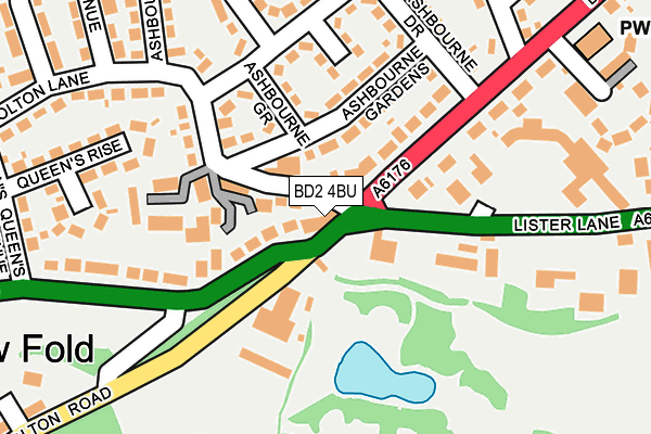
BD2 4BU is located in the Bolton and Undercliffe electoral ward, within the metropolitan district of Bradford and the English Parliamentary constituency of Bradford East. The Sub Integrated Care Board (ICB) Location is NHS West Yorkshire ICB - 36J and the police force is West Yorkshire. This postcode has been in use since January 1980.


GetTheData
Source: OS OpenMap – Local (Ordnance Survey)
Source: OS VectorMap District (Ordnance Survey)
Licence: Open Government Licence (requires attribution)
| Easting | 416873 |
| Northing | 434990 |
| Latitude | 53.810928 |
| Longitude | -1.745240 |
GetTheData
Source: Open Postcode Geo
Licence: Open Government Licence
| Country | England |
| Postcode District | BD2 |
➜ See where BD2 is on a map ➜ Where is Bradford? | |
GetTheData
Source: Land Registry Price Paid Data
Licence: Open Government Licence
Elevation or altitude of BD2 4BU as distance above sea level:
| Metres | Feet | |
|---|---|---|
| Elevation | 150m | 492ft |
Elevation is measured from the approximate centre of the postcode, to the nearest point on an OS contour line from OS Terrain 50, which has contour spacing of ten vertical metres.
➜ How high above sea level am I? Find the elevation of your current position using your device's GPS.
GetTheData
Source: Open Postcode Elevation
Licence: Open Government Licence
| Ward | Bolton And Undercliffe |
| Constituency | Bradford East |
GetTheData
Source: ONS Postcode Database
Licence: Open Government Licence
| Bolton Rd Lister Lane (Bolton Road) | Bolton | 40m |
| Bolton Road Queens Rd (Bolton Road) | Bolton | 55m |
| Bolton Rd Lister Lane (Bolton Road) | Bolton | 112m |
| Ashbourne Rd Ashbourne Ave (Ashbourne Road) | Bolton | 176m |
| Ashbourne Rd Ashbourne Ave (Ashbourne Road) | Bolton | 179m |
| Bradford Forster Square Station | 1.6km |
| Frizinghall Station | 1.9km |
| Bradford Interchange Station | 2.2km |
GetTheData
Source: NaPTAN
Licence: Open Government Licence
| Percentage of properties with Next Generation Access | 100.0% |
| Percentage of properties with Superfast Broadband | 100.0% |
| Percentage of properties with Ultrafast Broadband | 0.0% |
| Percentage of properties with Full Fibre Broadband | 0.0% |
Superfast Broadband is between 30Mbps and 300Mbps
Ultrafast Broadband is > 300Mbps
| Percentage of properties unable to receive 2Mbps | 0.0% |
| Percentage of properties unable to receive 5Mbps | 0.0% |
| Percentage of properties unable to receive 10Mbps | 0.0% |
| Percentage of properties unable to receive 30Mbps | 0.0% |
GetTheData
Source: Ofcom
Licence: Ofcom Terms of Use (requires attribution)
GetTheData
Source: ONS Postcode Database
Licence: Open Government Licence


➜ Get more ratings from the Food Standards Agency
GetTheData
Source: Food Standards Agency
Licence: FSA terms & conditions
| Last Collection | |||
|---|---|---|---|
| Location | Mon-Fri | Sat | Distance |
| 1043 Bolton Road | 17:00 | 11:00 | 75m |
| 46 Cliffe Road | 18:00 | 11:45 | 483m |
| 2 Springwood Terrace | 17:45 | 10:00 | 508m |
GetTheData
Source: Dracos
Licence: Creative Commons Attribution-ShareAlike
The below table lists the International Territorial Level (ITL) codes (formerly Nomenclature of Territorial Units for Statistics (NUTS) codes) and Local Administrative Units (LAU) codes for BD2 4BU:
| ITL 1 Code | Name |
|---|---|
| TLE | Yorkshire and The Humber |
| ITL 2 Code | Name |
| TLE4 | West Yorkshire |
| ITL 3 Code | Name |
| TLE41 | Bradford |
| LAU 1 Code | Name |
| E08000032 | Bradford |
GetTheData
Source: ONS Postcode Directory
Licence: Open Government Licence
The below table lists the Census Output Area (OA), Lower Layer Super Output Area (LSOA), and Middle Layer Super Output Area (MSOA) for BD2 4BU:
| Code | Name | |
|---|---|---|
| OA | E00053541 | |
| LSOA | E01010602 | Bradford 028E |
| MSOA | E02002210 | Bradford 028 |
GetTheData
Source: ONS Postcode Directory
Licence: Open Government Licence
| BD2 4AA | Bolton Lane | 25m |
| BD2 4AB | Tetley Place | 99m |
| BD2 4AE | Ashbourne Gardens | 106m |
| BD2 4LN | Bolton Road | 114m |
| BD2 4AF | Ashbourne Grove | 124m |
| BD2 4AT | Bolton Lane | 132m |
| BD2 4LS | Severn Road | 132m |
| BD2 4AN | Ashbourne Road | 137m |
| BD2 4AL | Ashbourne Bank | 145m |
| BD2 4AD | Low Fold | 146m |
GetTheData
Source: Open Postcode Geo; Land Registry Price Paid Data
Licence: Open Government Licence