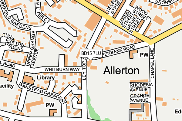
BD15 7LU lies on Greenbank Road in Allerton, Bradford. BD15 7LU is located in the Thornton and Allerton electoral ward, within the metropolitan district of Bradford and the English Parliamentary constituency of Bradford West. The Sub Integrated Care Board (ICB) Location is NHS West Yorkshire ICB - 36J and the police force is West Yorkshire. This postcode has been in use since January 1980.


GetTheData
Source: OS OpenMap – Local (Ordnance Survey)
Source: OS VectorMap District (Ordnance Survey)
Licence: Open Government Licence (requires attribution)
| Easting | 412074 |
| Northing | 433959 |
| Latitude | 53.801794 |
| Longitude | -1.818160 |
GetTheData
Source: Open Postcode Geo
Licence: Open Government Licence
| Street | Greenbank Road |
| Locality | Allerton |
| Town/City | Bradford |
| Country | England |
| Postcode District | BD15 |
➜ See where BD15 is on a map ➜ Where is Bradford? | |
GetTheData
Source: Land Registry Price Paid Data
Licence: Open Government Licence
Elevation or altitude of BD15 7LU as distance above sea level:
| Metres | Feet | |
|---|---|---|
| Elevation | 210m | 689ft |
Elevation is measured from the approximate centre of the postcode, to the nearest point on an OS contour line from OS Terrain 50, which has contour spacing of ten vertical metres.
➜ How high above sea level am I? Find the elevation of your current position using your device's GPS.
GetTheData
Source: Open Postcode Elevation
Licence: Open Government Licence
| Ward | Thornton And Allerton |
| Constituency | Bradford West |
GetTheData
Source: ONS Postcode Database
Licence: Open Government Licence
23, GREENBANK ROAD, ALLERTON, BRADFORD, BD15 7LU 2004 30 DEC £220,000 |
BEECH HOUSE, GREENBANK ROAD, ALLERTON, BRADFORD, BD15 7LU 2002 1 MAY £190,000 |
23, GREENBANK ROAD, ALLERTON, BRADFORD, BD15 7LU 1999 2 AUG £135,000 |
GetTheData
Source: HM Land Registry Price Paid Data
Licence: Contains HM Land Registry data © Crown copyright and database right 2025. This data is licensed under the Open Government Licence v3.0.
| Allerton Rd Prospect Terrace (Allerton Road) | Allerton | 169m |
| Allerton Rd Prospect Terrace (Allerton Road) | Allerton | 176m |
| Allerton Road Dene Mount (Allerton Road) | Allerton | 193m |
| Allerton Road Dene Mount (Allerton Road) | Allerton | 225m |
| Community Centre Saffron Drive (Saffron Drive) | Allerton | 338m |
| Frizinghall Station | 3.8km |
| Bradford Forster Square Station | 4.3km |
| Saltaire Station | 4.5km |
GetTheData
Source: NaPTAN
Licence: Open Government Licence
| Percentage of properties with Next Generation Access | 80.0% |
| Percentage of properties with Superfast Broadband | 80.0% |
| Percentage of properties with Ultrafast Broadband | 20.0% |
| Percentage of properties with Full Fibre Broadband | 0.0% |
Superfast Broadband is between 30Mbps and 300Mbps
Ultrafast Broadband is > 300Mbps
| Percentage of properties unable to receive 2Mbps | 0.0% |
| Percentage of properties unable to receive 5Mbps | 0.0% |
| Percentage of properties unable to receive 10Mbps | 20.0% |
| Percentage of properties unable to receive 30Mbps | 20.0% |
GetTheData
Source: Ofcom
Licence: Ofcom Terms of Use (requires attribution)
GetTheData
Source: ONS Postcode Database
Licence: Open Government Licence


➜ Get more ratings from the Food Standards Agency
GetTheData
Source: Food Standards Agency
Licence: FSA terms & conditions
| Last Collection | |||
|---|---|---|---|
| Location | Mon-Fri | Sat | Distance |
| Allerton Franchise P.o. Box | 17:15 | 12:15 | 485m |
| Town End Road Clayton | 17:15 | 12:00 | 1,854m |
| 90 Hunters Park Avenue Clayton | 17:30 | 12:15 | 1,905m |
GetTheData
Source: Dracos
Licence: Creative Commons Attribution-ShareAlike
The below table lists the International Territorial Level (ITL) codes (formerly Nomenclature of Territorial Units for Statistics (NUTS) codes) and Local Administrative Units (LAU) codes for BD15 7LU:
| ITL 1 Code | Name |
|---|---|
| TLE | Yorkshire and The Humber |
| ITL 2 Code | Name |
| TLE4 | West Yorkshire |
| ITL 3 Code | Name |
| TLE41 | Bradford |
| LAU 1 Code | Name |
| E08000032 | Bradford |
GetTheData
Source: ONS Postcode Directory
Licence: Open Government Licence
The below table lists the Census Output Area (OA), Lower Layer Super Output Area (LSOA), and Middle Layer Super Output Area (MSOA) for BD15 7LU:
| Code | Name | |
|---|---|---|
| OA | E00054441 | |
| LSOA | E01010801 | Bradford 036E |
| MSOA | E02002218 | Bradford 036 |
GetTheData
Source: ONS Postcode Directory
Licence: Open Government Licence
| BD15 7LT | Ley Top Lane | 77m |
| BD15 7LX | Avenel Terrace | 82m |
| BD15 7DF | Whitburn Way | 93m |
| BD15 7RH | Greenbank Road | 112m |
| BD15 7DW | Daffodil Court | 129m |
| BD15 7PR | Freshfield Gardens | 132m |
| BD15 7RD | Allerton Road | 141m |
| BD15 7DG | Snowdrop Mews | 142m |
| BD15 7RL | Rhodesia Avenue | 166m |
| BD15 7PA | Wanstead Crescent | 171m |
GetTheData
Source: Open Postcode Geo; Land Registry Price Paid Data
Licence: Open Government Licence