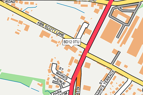
BD12 0TU is located in the Royds electoral ward, within the metropolitan district of Bradford and the English Parliamentary constituency of Bradford South. The Sub Integrated Care Board (ICB) Location is NHS West Yorkshire ICB - 36J and the police force is West Yorkshire. This postcode has been in use since January 1980.


GetTheData
Source: OS OpenMap – Local (Ordnance Survey)
Source: OS VectorMap District (Ordnance Survey)
Licence: Open Government Licence (requires attribution)
| Easting | 415246 |
| Northing | 428533 |
| Latitude | 53.752958 |
| Longitude | -1.770269 |
GetTheData
Source: Open Postcode Geo
Licence: Open Government Licence
| Country | England |
| Postcode District | BD12 |
➜ See where BD12 is on a map ➜ Where is Bradford? | |
GetTheData
Source: Land Registry Price Paid Data
Licence: Open Government Licence
Elevation or altitude of BD12 0TU as distance above sea level:
| Metres | Feet | |
|---|---|---|
| Elevation | 180m | 591ft |
Elevation is measured from the approximate centre of the postcode, to the nearest point on an OS contour line from OS Terrain 50, which has contour spacing of ten vertical metres.
➜ How high above sea level am I? Find the elevation of your current position using your device's GPS.
GetTheData
Source: Open Postcode Elevation
Licence: Open Government Licence
| Ward | Royds |
| Constituency | Bradford South |
GetTheData
Source: ONS Postcode Database
Licence: Open Government Licence
| Huddersfield Rd Abb Scott Lane (Huddersfield Road) | Low Moor | 78m |
| Huddersfield Rd Abb Scott Lane (Huddersfield Road) | Low Moor | 137m |
| Huddersfield Rd The Gateways (Huddersfield Road) | Low Moor | 297m |
| Drop Kick Ph (Huddersfield Road) | Low Moor | 315m |
| Huddersfield Rd The Gateways (Huddersfield Road) | Low Moor | 386m |
| Low Moor Station | 1.2km |
| Bradford Interchange Station | 4.5km |
| Bradford Forster Square Station | 5km |
GetTheData
Source: NaPTAN
Licence: Open Government Licence
GetTheData
Source: ONS Postcode Database
Licence: Open Government Licence


➜ Get more ratings from the Food Standards Agency
GetTheData
Source: Food Standards Agency
Licence: FSA terms & conditions
| Last Collection | |||
|---|---|---|---|
| Location | Mon-Fri | Sat | Distance |
| Oxley Gardens | 17:15 | 12:45 | 488m |
| Low Moor Business Box | 18:30 | 11:45 | 496m |
| Carr Lane | 17:00 | 12:00 | 576m |
GetTheData
Source: Dracos
Licence: Creative Commons Attribution-ShareAlike
The below table lists the International Territorial Level (ITL) codes (formerly Nomenclature of Territorial Units for Statistics (NUTS) codes) and Local Administrative Units (LAU) codes for BD12 0TU:
| ITL 1 Code | Name |
|---|---|
| TLE | Yorkshire and The Humber |
| ITL 2 Code | Name |
| TLE4 | West Yorkshire |
| ITL 3 Code | Name |
| TLE41 | Bradford |
| LAU 1 Code | Name |
| E08000032 | Bradford |
GetTheData
Source: ONS Postcode Directory
Licence: Open Government Licence
The below table lists the Census Output Area (OA), Lower Layer Super Output Area (LSOA), and Middle Layer Super Output Area (MSOA) for BD12 0TU:
| Code | Name | |
|---|---|---|
| OA | E00054791 | |
| LSOA | E01010867 | Bradford 059G |
| MSOA | E02002241 | Bradford 059 |
GetTheData
Source: ONS Postcode Directory
Licence: Open Government Licence
| BD12 0TH | The Plantations | 104m |
| BD12 0TY | St Marks Avenue | 106m |
| BD12 0TX | Woodside Road | 111m |
| BD12 0UD | New Works Road | 144m |
| BD12 0TT | Abb Scott Lane | 150m |
| BD12 0TZ | Harold Court | 167m |
| BD12 0UA | Park Bottom | 171m |
| BD12 0UE | St Marks Terrace | 174m |
| BD12 0UQ | St Marks Place | 192m |
| BD12 0NB | Low Moor Industrial Estate | 205m |
GetTheData
Source: Open Postcode Geo; Land Registry Price Paid Data
Licence: Open Government Licence