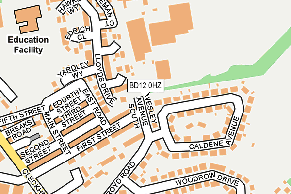
BD12 0HZ is located in the Wyke electoral ward, within the metropolitan district of Bradford and the English Parliamentary constituency of Bradford South. The Sub Integrated Care Board (ICB) Location is NHS West Yorkshire ICB - 36J and the police force is West Yorkshire. This postcode has been in use since May 1994.


GetTheData
Source: OS OpenMap – Local (Ordnance Survey)
Source: OS VectorMap District (Ordnance Survey)
Licence: Open Government Licence (requires attribution)
| Easting | 416298 |
| Northing | 428699 |
| Latitude | 53.754403 |
| Longitude | -1.754303 |
GetTheData
Source: Open Postcode Geo
Licence: Open Government Licence
| Country | England |
| Postcode District | BD12 |
➜ See where BD12 is on a map ➜ Where is Bradford? | |
GetTheData
Source: Land Registry Price Paid Data
Licence: Open Government Licence
Elevation or altitude of BD12 0HZ as distance above sea level:
| Metres | Feet | |
|---|---|---|
| Elevation | 160m | 525ft |
Elevation is measured from the approximate centre of the postcode, to the nearest point on an OS contour line from OS Terrain 50, which has contour spacing of ten vertical metres.
➜ How high above sea level am I? Find the elevation of your current position using your device's GPS.
GetTheData
Source: Open Postcode Elevation
Licence: Open Government Licence
| Ward | Wyke |
| Constituency | Bradford South |
GetTheData
Source: ONS Postcode Database
Licence: Open Government Licence
4, WESLEY AVENUE SOUTH, LOW MOOR, BRADFORD, BD12 0HZ 2022 8 JUL £215,000 |
GetTheData
Source: HM Land Registry Price Paid Data
Licence: Contains HM Land Registry data © Crown copyright and database right 2025. This data is licensed under the Open Government Licence v3.0.
| Cleckheaton Road Chapel Rd (Cleckheaton Road) | Low Moor | 292m |
| Cleckheaton Road Chapel Rd (Cleckheaton Road) | Low Moor | 299m |
| Cleckheaton Road Terry Rd (Cleckheaton Road) | Low Moor | 349m |
| Cleckheaton Road New Works Rd (Cleckheaton Road) | Low Moor | 391m |
| Cleckheaton Rd Hird Road (Cleckheaton Road) | Low Moor | 468m |
| Low Moor Station | 0.5km |
| Bradford Interchange Station | 4.1km |
| Bradford Forster Square Station | 4.7km |
GetTheData
Source: NaPTAN
Licence: Open Government Licence
| Percentage of properties with Next Generation Access | 100.0% |
| Percentage of properties with Superfast Broadband | 100.0% |
| Percentage of properties with Ultrafast Broadband | 0.0% |
| Percentage of properties with Full Fibre Broadband | 0.0% |
Superfast Broadband is between 30Mbps and 300Mbps
Ultrafast Broadband is > 300Mbps
| Percentage of properties unable to receive 2Mbps | 0.0% |
| Percentage of properties unable to receive 5Mbps | 0.0% |
| Percentage of properties unable to receive 10Mbps | 0.0% |
| Percentage of properties unable to receive 30Mbps | 0.0% |
GetTheData
Source: Ofcom
Licence: Ofcom Terms of Use (requires attribution)
GetTheData
Source: ONS Postcode Database
Licence: Open Government Licence


➜ Get more ratings from the Food Standards Agency
GetTheData
Source: Food Standards Agency
Licence: FSA terms & conditions
| Last Collection | |||
|---|---|---|---|
| Location | Mon-Fri | Sat | Distance |
| Carr Lane | 17:00 | 12:00 | 659m |
| Low Moor Business Box | 18:30 | 11:45 | 705m |
| 451 Cleckheaton Road | 17:45 | 11:45 | 885m |
GetTheData
Source: Dracos
Licence: Creative Commons Attribution-ShareAlike
The below table lists the International Territorial Level (ITL) codes (formerly Nomenclature of Territorial Units for Statistics (NUTS) codes) and Local Administrative Units (LAU) codes for BD12 0HZ:
| ITL 1 Code | Name |
|---|---|
| TLE | Yorkshire and The Humber |
| ITL 2 Code | Name |
| TLE4 | West Yorkshire |
| ITL 3 Code | Name |
| TLE41 | Bradford |
| LAU 1 Code | Name |
| E08000032 | Bradford |
GetTheData
Source: ONS Postcode Directory
Licence: Open Government Licence
The below table lists the Census Output Area (OA), Lower Layer Super Output Area (LSOA), and Middle Layer Super Output Area (MSOA) for BD12 0HZ:
| Code | Name | |
|---|---|---|
| OA | E00054780 | |
| LSOA | E01010865 | Bradford 060D |
| MSOA | E02002242 | Bradford 060 |
GetTheData
Source: ONS Postcode Directory
Licence: Open Government Licence
| BD12 0JG | Carricks Close | 45m |
| BD12 0JR | Caldene Avenue | 98m |
| BD12 0JP | Caldene Avenue | 122m |
| BD12 0JQ | First Street | 132m |
| BD12 0JW | Calde Court | 141m |
| BD12 0HB | Lloyds Drive | 144m |
| BD12 0JS | Salroyd Road | 145m |
| BD12 0JF | Yardley Way | 151m |
| BD12 0JB | Third Street | 156m |
| BD12 0JA | Fourth Street | 163m |
GetTheData
Source: Open Postcode Geo; Land Registry Price Paid Data
Licence: Open Government Licence