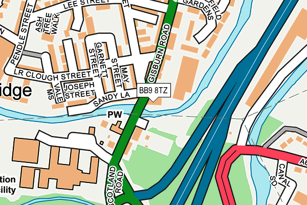
BB9 8TZ is located in the Barrowford & Pendleside electoral ward, within the local authority district of Pendle and the English Parliamentary constituency of Pendle. The Sub Integrated Care Board (ICB) Location is NHS Lancashire and South Cumbria ICB - 01A and the police force is Lancashire. This postcode has been in use since February 2017.


GetTheData
Source: OS OpenMap – Local (Ordnance Survey)
Source: OS VectorMap District (Ordnance Survey)
Licence: Open Government Licence (requires attribution)
| Easting | 385750 |
| Northing | 438851 |
| Latitude | 53.845716 |
| Longitude | -2.218071 |
GetTheData
Source: Open Postcode Geo
Licence: Open Government Licence
| Country | England |
| Postcode District | BB9 |
| ➜ BB9 open data dashboard ➜ See where BB9 is on a map ➜ Where is Barrowford? | |
GetTheData
Source: Land Registry Price Paid Data
Licence: Open Government Licence
| Ward | Barrowford & Pendleside |
| Constituency | Pendle |
GetTheData
Source: ONS Postcode Database
Licence: Open Government Licence
| January 2024 | Criminal damage and arson | On or near Bolton Grove | 340m |
| January 2024 | Anti-social behaviour | On or near Bolton Grove | 340m |
| January 2024 | Anti-social behaviour | On or near Bolton Grove | 340m |
| ➜ Get more crime data in our Crime section | |||
GetTheData
Source: data.police.uk
Licence: Open Government Licence
| Roughlee Street (Gisburn Road) | Barrowford | 40m |
| Nelson And Colne College (Scotland Road) | Barrowford | 105m |
| Victoria Hotel (Grey Street) | Barrowford | 107m |
| Nelson And Colne College (Scotland Road) | Barrowford | 177m |
| Holy Saviours School Stop (Reedyford Road) | Nelson | 267m |
| Nelson Station | 1.2km |
| Colne Station | 2.6km |
| Brierfield Station | 2.7km |
GetTheData
Source: NaPTAN
Licence: Open Government Licence
GetTheData
Source: ONS Postcode Database
Licence: Open Government Licence


➜ Get more ratings from the Food Standards Agency
GetTheData
Source: Food Standards Agency
Licence: FSA terms & conditions
| Last Collection | |||
|---|---|---|---|
| Location | Mon-Fri | Sat | Distance |
| 178 Hibson Road | 16:00 | 11:00 | 1,203m |
| 46 Carr Road | 16:00 | 11:00 | 1,288m |
| Hill Place | 17:30 | 12:00 | 1,924m |
GetTheData
Source: Dracos
Licence: Creative Commons Attribution-ShareAlike
| Facility | Distance |
|---|---|
| Nelson And Colne College Scotland Road, Nelson Grass Pitches, Sports Hall, Health and Fitness Gym, Artificial Grass Pitch, Outdoor Tennis Courts | 248m |
| Bullholme Playing Field Wilton Street, Barrowford Grass Pitches | 364m |
| Seedhill Athletics & Fitness Centre Surrey Road, Nelson Athletics, Health and Fitness Gym | 394m |
GetTheData
Source: Active Places
Licence: Open Government Licence
| School | Phase of Education | Distance |
|---|---|---|
| Nelson and Colne College Scotland Road, Nelson, BB9 7YT | 16 plus | 264m |
| Holy Saviour Roman Catholic Primary School, Nelson Holland Place, Off Reedyford Road, Nelson, BB9 8HD | Primary | 370m |
| Barrowford School Rushton Street, Barrowford, Nelson, BB9 6EA | Primary | 618m |
GetTheData
Source: Edubase
Licence: Open Government Licence
| Risk of BB9 8TZ flooding from rivers and sea | Low |
| ➜ BB9 8TZ flood map | |
GetTheData
Source: Open Flood Risk by Postcode
Licence: Open Government Licence
The below table lists the International Territorial Level (ITL) codes (formerly Nomenclature of Territorial Units for Statistics (NUTS) codes) and Local Administrative Units (LAU) codes for BB9 8TZ:
| ITL 1 Code | Name |
|---|---|
| TLD | North West (England) |
| ITL 2 Code | Name |
| TLD4 | Lancashire |
| ITL 3 Code | Name |
| TLD46 | East Lancashire |
| LAU 1 Code | Name |
| E07000122 | Pendle |
GetTheData
Source: ONS Postcode Directory
Licence: Open Government Licence
The below table lists the Census Output Area (OA), Lower Layer Super Output Area (LSOA), and Middle Layer Super Output Area (MSOA) for BB9 8TZ:
| Code | Name | |
|---|---|---|
| OA | E00127778 | |
| LSOA | E01025176 | Pendle 008C |
| MSOA | E02005247 | Pendle 008 |
GetTheData
Source: ONS Postcode Directory
Licence: Open Government Licence
| BB9 8NB | Gisburn Road | 66m |
| BB9 8NY | Sandy Lane | 99m |
| BB9 8NX | Maud Street | 110m |
| BB9 7YS | Scotland Road | 116m |
| BB9 8NJ | King Edward Terrace | 121m |
| BB9 8NZ | May Street | 125m |
| BB9 8NS | Nora Street | 141m |
| BB9 8NN | Grey Street | 151m |
| BB9 8PA | Garnett Street | 155m |
| BB9 8NL | Gladstone Terrace | 164m |
GetTheData
Source: Open Postcode Geo; Land Registry Price Paid Data
Licence: Open Government Licence