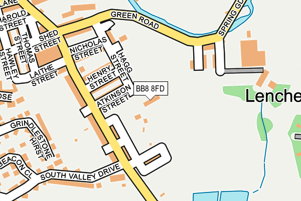
BB8 8FD lies on Paddock Top Mews in Colne. BB8 8FD is located in the Waterside & Horsfield electoral ward, within the local authority district of Pendle and the English Parliamentary constituency of Pendle. The Sub Integrated Care Board (ICB) Location is NHS Lancashire and South Cumbria ICB - 01A and the police force is Lancashire. This postcode has been in use since November 2006.


GetTheData
Source: OS OpenMap – Local (Ordnance Survey)
Source: OS VectorMap District (Ordnance Survey)
Licence: Open Government Licence (requires attribution)
| Easting | 388555 |
| Northing | 439490 |
| Latitude | 53.851515 |
| Longitude | -2.175461 |
GetTheData
Source: Open Postcode Geo
Licence: Open Government Licence
| Street | Paddock Top Mews |
| Town/City | Colne |
| Country | England |
| Postcode District | BB8 |
➜ See where BB8 is on a map ➜ Where is Colne? | |
GetTheData
Source: Land Registry Price Paid Data
Licence: Open Government Licence
Elevation or altitude of BB8 8FD as distance above sea level:
| Metres | Feet | |
|---|---|---|
| Elevation | 160m | 525ft |
Elevation is measured from the approximate centre of the postcode, to the nearest point on an OS contour line from OS Terrain 50, which has contour spacing of ten vertical metres.
➜ How high above sea level am I? Find the elevation of your current position using your device's GPS.
GetTheData
Source: Open Postcode Elevation
Licence: Open Government Licence
| Ward | Waterside & Horsfield |
| Constituency | Pendle |
GetTheData
Source: ONS Postcode Database
Licence: Open Government Licence
| Atkinson Street (Knotts Lane) | Lenches | 125m |
| Spring Gardens Lane (Green Road) | Lenches | 175m |
| Green Road (Knotts Lane) | Lenches | 198m |
| The Sidings (Khyber Street) | Lenches | 329m |
| Hawley Street | Lenches | 330m |
| Colne Station | 0.6km |
| Nelson Station | 3.1km |
| Brierfield Station | 5.1km |
GetTheData
Source: NaPTAN
Licence: Open Government Licence
| Percentage of properties with Next Generation Access | 100.0% |
| Percentage of properties with Superfast Broadband | 100.0% |
| Percentage of properties with Ultrafast Broadband | 0.0% |
| Percentage of properties with Full Fibre Broadband | 0.0% |
Superfast Broadband is between 30Mbps and 300Mbps
Ultrafast Broadband is > 300Mbps
| Median download speed | 40.0Mbps |
| Average download speed | 45.0Mbps |
| Maximum download speed | 80.00Mbps |
| Median upload speed | 10.0Mbps |
| Average upload speed | 10.8Mbps |
| Maximum upload speed | 20.00Mbps |
| Percentage of properties unable to receive 2Mbps | 0.0% |
| Percentage of properties unable to receive 5Mbps | 0.0% |
| Percentage of properties unable to receive 10Mbps | 0.0% |
| Percentage of properties unable to receive 30Mbps | 0.0% |
GetTheData
Source: Ofcom
Licence: Ofcom Terms of Use (requires attribution)
Estimated total energy consumption in BB8 8FD by fuel type, 2015.
| Consumption (kWh) | 16,251 |
|---|---|
| Meter count | 8 |
| Mean (kWh/meter) | 2,031 |
| Median (kWh/meter) | 1,983 |
GetTheData
Source: Postcode level gas estimates: 2015 (experimental)
Source: Postcode level electricity estimates: 2015 (experimental)
Licence: Open Government Licence
GetTheData
Source: ONS Postcode Database
Licence: Open Government Licence


➜ Get more ratings from the Food Standards Agency
GetTheData
Source: Food Standards Agency
Licence: FSA terms & conditions
| Last Collection | |||
|---|---|---|---|
| Location | Mon-Fri | Sat | Distance |
| Broken Banks | 16:00 | 11:00 | 353m |
| Crabtree Street | 16:00 | 11:00 | 423m |
| Colne Post Office | 18:00 | 12:00 | 498m |
GetTheData
Source: Dracos
Licence: Creative Commons Attribution-ShareAlike
The below table lists the International Territorial Level (ITL) codes (formerly Nomenclature of Territorial Units for Statistics (NUTS) codes) and Local Administrative Units (LAU) codes for BB8 8FD:
| ITL 1 Code | Name |
|---|---|
| TLD | North West (England) |
| ITL 2 Code | Name |
| TLD4 | Lancashire |
| ITL 3 Code | Name |
| TLD46 | East Lancashire |
| LAU 1 Code | Name |
| E07000122 | Pendle |
GetTheData
Source: ONS Postcode Directory
Licence: Open Government Licence
The below table lists the Census Output Area (OA), Lower Layer Super Output Area (LSOA), and Middle Layer Super Output Area (MSOA) for BB8 8FD:
| Code | Name | |
|---|---|---|
| OA | E00128046 | |
| LSOA | E01025226 | Pendle 007A |
| MSOA | E02005246 | Pendle 007 |
GetTheData
Source: ONS Postcode Directory
Licence: Open Government Licence
| BB8 8AT | Atkinson Street | 70m |
| BB8 8AS | Henry Street | 95m |
| BB8 8AB | Knotts Lane | 108m |
| BB8 8AU | Dewhurst Street | 119m |
| BB8 8EH | Peerart Court | 123m |
| BB8 8AE | Knotts Lane | 124m |
| BB8 8EP | Short Street | 134m |
| BB8 8EW | Cross Helliwell Street | 137m |
| BB8 8ER | Daisy Street | 145m |
| BB8 8AW | Hagg Street | 152m |
GetTheData
Source: Open Postcode Geo; Land Registry Price Paid Data
Licence: Open Government Licence