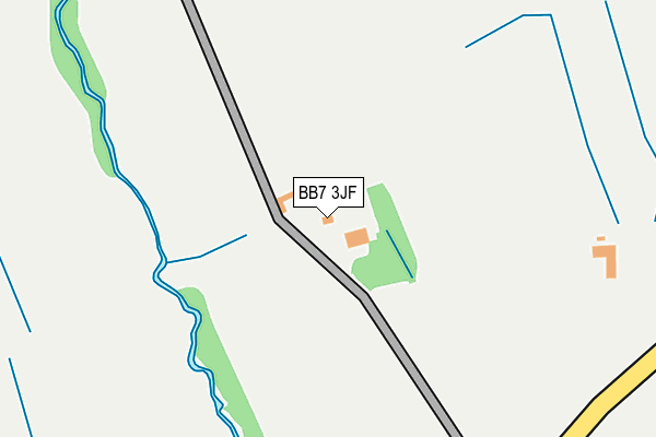
BB7 3JF lies on Waddington Road in West Bradford, Clitheroe. BB7 3JF is located in the West Bradford & Grindleton electoral ward, within the local authority district of Ribble Valley and the English Parliamentary constituency of Ribble Valley. The Sub Integrated Care Board (ICB) Location is NHS Lancashire and South Cumbria ICB - 01A and the police force is Lancashire. This postcode has been in use since January 1980.


GetTheData
Source: OS OpenMap – Local (Ordnance Survey)
Source: OS VectorMap District (Ordnance Survey)
Licence: Open Government Licence (requires attribution)
| Easting | 373432 |
| Northing | 444409 |
| Latitude | 53.895168 |
| Longitude | -2.405771 |
GetTheData
Source: Open Postcode Geo
Licence: Open Government Licence
| Street | Waddington Road |
| Locality | West Bradford |
| Town/City | Clitheroe |
| Country | England |
| Postcode District | BB7 |
➜ See where BB7 is on a map ➜ Where is Waddington? | |
GetTheData
Source: Land Registry Price Paid Data
Licence: Open Government Licence
Elevation or altitude of BB7 3JF as distance above sea level:
| Metres | Feet | |
|---|---|---|
| Elevation | 100m | 328ft |
Elevation is measured from the approximate centre of the postcode, to the nearest point on an OS contour line from OS Terrain 50, which has contour spacing of ten vertical metres.
➜ How high above sea level am I? Find the elevation of your current position using your device's GPS.
GetTheData
Source: Open Postcode Elevation
Licence: Open Government Licence
| Ward | West Bradford & Grindleton |
| Constituency | Ribble Valley |
GetTheData
Source: ONS Postcode Database
Licence: Open Government Licence
MEADOW HEAD, WADDINGTON ROAD, WEST BRADFORD, CLITHEROE, BB7 3JF 2019 15 NOV £650,000 |
SCAR HEAD COTTAGE, WADDINGTON ROAD, WEST BRADFORD, CLITHEROE, BB7 3JF 2018 5 JAN £530,000 |
2011 4 JUL £640,000 |
EAVES HOUSE BARN, WADDINGTON ROAD, WEST BRADFORD, CLITHEROE, BB7 3JF 2010 19 MAR £595,000 |
THE STABLES, WADDINGTON ROAD, WEST BRADFORD, CLITHEROE, BB7 3JF 2006 29 SEP £370,000 |
SCAR HEAD COTTAGE, WADDINGTON ROAD, WEST BRADFORD, CLITHEROE, BB7 3JF 2002 4 JAN £193,500 |
OWL COTTAGE, WADDINGTON ROAD, WEST BRADFORD, CLITHEROE, BB7 3JF 2000 12 MAY £285,000 |
1995 24 AUG £109,000 |
LINTON CROFT HOUSE, WADDINGTON ROAD, WEST BRADFORD, CLITHEROE, BB7 3JF 1995 27 JAN £235,000 |
GetTheData
Source: HM Land Registry Price Paid Data
Licence: Contains HM Land Registry data © Crown copyright and database right 2025. This data is licensed under the Open Government Licence v3.0.
| Waddington And West Bradford Ceps (West Bradford Road) | Waddington | 388m |
| Hospital (West Bradford Road) | Waddington | 699m |
| Waddington Arms (The Square) | Waddington | 760m |
| Pilling Farm (Grindleton Road) | West Bradford | 846m |
| Pilling Farm (Grindleton Road) | West Bradford | 847m |
| Clitheroe Station | 2.5km |
GetTheData
Source: NaPTAN
Licence: Open Government Licence
| Percentage of properties with Next Generation Access | 100.0% |
| Percentage of properties with Superfast Broadband | 12.5% |
| Percentage of properties with Ultrafast Broadband | 0.0% |
| Percentage of properties with Full Fibre Broadband | 0.0% |
Superfast Broadband is between 30Mbps and 300Mbps
Ultrafast Broadband is > 300Mbps
| Median download speed | 3.3Mbps |
| Average download speed | 10.2Mbps |
| Maximum download speed | 39.06Mbps |
| Median upload speed | 1.2Mbps |
| Average upload speed | 2.4Mbps |
| Maximum upload speed | 8.42Mbps |
| Percentage of properties unable to receive 2Mbps | 0.0% |
| Percentage of properties unable to receive 5Mbps | 12.5% |
| Percentage of properties unable to receive 10Mbps | 62.5% |
| Percentage of properties unable to receive 30Mbps | 87.5% |
GetTheData
Source: Ofcom
Licence: Ofcom Terms of Use (requires attribution)
GetTheData
Source: ONS Postcode Database
Licence: Open Government Licence


➜ Get more ratings from the Food Standards Agency
GetTheData
Source: Food Standards Agency
Licence: FSA terms & conditions
| Last Collection | |||
|---|---|---|---|
| Location | Mon-Fri | Sat | Distance |
| 144 Chatburn Road | 16:00 | 11:30 | 2,365m |
| 2 Beverley Drive | 17:00 | 11:00 | 3,656m |
GetTheData
Source: Dracos
Licence: Creative Commons Attribution-ShareAlike
The below table lists the International Territorial Level (ITL) codes (formerly Nomenclature of Territorial Units for Statistics (NUTS) codes) and Local Administrative Units (LAU) codes for BB7 3JF:
| ITL 1 Code | Name |
|---|---|
| TLD | North West (England) |
| ITL 2 Code | Name |
| TLD4 | Lancashire |
| ITL 3 Code | Name |
| TLD45 | Mid Lancashire |
| LAU 1 Code | Name |
| E07000124 | Ribble Valley |
GetTheData
Source: ONS Postcode Directory
Licence: Open Government Licence
The below table lists the Census Output Area (OA), Lower Layer Super Output Area (LSOA), and Middle Layer Super Output Area (MSOA) for BB7 3JF:
| Code | Name | |
|---|---|---|
| OA | E00128653 | |
| LSOA | E01025348 | Ribble Valley 001D |
| MSOA | E02005270 | Ribble Valley 001 |
GetTheData
Source: ONS Postcode Directory
Licence: Open Government Licence
| BB7 3JE | West Bradford Road | 356m |
| BB7 3JD | West Bradford Road | 545m |
| BB7 3HR | Branch Road | 704m |
| BB7 4SX | Waddington Road | 721m |
| BB7 4SY | Millstone Cottages | 726m |
| BB7 3HP | Clitheroe Road | 761m |
| BB7 3HZ | The Square | 770m |
| BB7 3HS | Beech Mount | 790m |
| BB7 3JG | Eaves Hall Lane | 790m |
| BB7 3JA | Regent Street | 800m |
GetTheData
Source: Open Postcode Geo; Land Registry Price Paid Data
Licence: Open Government Licence