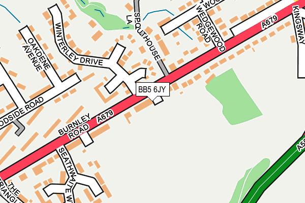
BB5 6JY lies on Moorfield Avenue in Accrington. BB5 6JY is located in the Huncoat electoral ward, within the local authority district of Hyndburn and the English Parliamentary constituency of Hyndburn. The Sub Integrated Care Board (ICB) Location is NHS Lancashire and South Cumbria ICB - 01A and the police force is Lancashire. This postcode has been in use since January 1980.


GetTheData
Source: OS OpenMap – Local (Ordnance Survey)
Source: OS VectorMap District (Ordnance Survey)
Licence: Open Government Licence (requires attribution)
| Easting | 377624 |
| Northing | 429956 |
| Latitude | 53.765467 |
| Longitude | -2.340925 |
GetTheData
Source: Open Postcode Geo
Licence: Open Government Licence
| Street | Moorfield Avenue |
| Town/City | Accrington |
| Country | England |
| Postcode District | BB5 |
➜ See where BB5 is on a map ➜ Where is Accrington? | |
GetTheData
Source: Land Registry Price Paid Data
Licence: Open Government Licence
Elevation or altitude of BB5 6JY as distance above sea level:
| Metres | Feet | |
|---|---|---|
| Elevation | 180m | 591ft |
Elevation is measured from the approximate centre of the postcode, to the nearest point on an OS contour line from OS Terrain 50, which has contour spacing of ten vertical metres.
➜ How high above sea level am I? Find the elevation of your current position using your device's GPS.
GetTheData
Source: Open Postcode Elevation
Licence: Open Government Licence
| Ward | Huncoat |
| Constituency | Hyndburn |
GetTheData
Source: ONS Postcode Database
Licence: Open Government Licence
| Winterley Drive (Burnley Road) | Huncoat | 21m |
| Spouthouse Lane (Burnley Road) | Huncoat | 39m |
| Higher Gate Road (Burnley Road) | Huncoat | 259m |
| Woodside Road (Oakfield Avenue) | Huncoat | 269m |
| Bolton Avenue (Burnley Road) | Huncoat | 294m |
| Huncoat Station | 0.8km |
| Accrington Station | 2.3km |
| Hapton Station | 2.4km |
GetTheData
Source: NaPTAN
Licence: Open Government Licence
| Percentage of properties with Next Generation Access | 100.0% |
| Percentage of properties with Superfast Broadband | 100.0% |
| Percentage of properties with Ultrafast Broadband | 100.0% |
| Percentage of properties with Full Fibre Broadband | 0.0% |
Superfast Broadband is between 30Mbps and 300Mbps
Ultrafast Broadband is > 300Mbps
| Percentage of properties unable to receive 2Mbps | 0.0% |
| Percentage of properties unable to receive 5Mbps | 0.0% |
| Percentage of properties unable to receive 10Mbps | 0.0% |
| Percentage of properties unable to receive 30Mbps | 0.0% |
GetTheData
Source: Ofcom
Licence: Ofcom Terms of Use (requires attribution)
GetTheData
Source: ONS Postcode Database
Licence: Open Government Licence


➜ Get more ratings from the Food Standards Agency
GetTheData
Source: Food Standards Agency
Licence: FSA terms & conditions
| Last Collection | |||
|---|---|---|---|
| Location | Mon-Fri | Sat | Distance |
| 52 Lancaster Avenue | 16:15 | 11:15 | 1,134m |
| 216 Willows Lane | 17:00 | 12:45 | 1,783m |
| Clayton Le Moors Post Office | 16:45 | 12:15 | 2,795m |
GetTheData
Source: Dracos
Licence: Creative Commons Attribution-ShareAlike
The below table lists the International Territorial Level (ITL) codes (formerly Nomenclature of Territorial Units for Statistics (NUTS) codes) and Local Administrative Units (LAU) codes for BB5 6JY:
| ITL 1 Code | Name |
|---|---|
| TLD | North West (England) |
| ITL 2 Code | Name |
| TLD4 | Lancashire |
| ITL 3 Code | Name |
| TLD46 | East Lancashire |
| LAU 1 Code | Name |
| E07000120 | Hyndburn |
GetTheData
Source: ONS Postcode Directory
Licence: Open Government Licence
The below table lists the Census Output Area (OA), Lower Layer Super Output Area (LSOA), and Middle Layer Super Output Area (MSOA) for BB5 6JY:
| Code | Name | |
|---|---|---|
| OA | E00127152 | |
| LSOA | E01025051 | Hyndburn 004A |
| MSOA | E02005215 | Hyndburn 004 |
GetTheData
Source: ONS Postcode Directory
Licence: Open Government Licence
| BB5 6UB | Headingley Close | 79m |
| BB5 6UA | Wessex Close | 104m |
| BB5 6UD | Hawkstone Close | 106m |
| BB5 6JU | Burnley Road | 144m |
| BB5 6JX | Longsight Avenue | 160m |
| BB5 6LB | Spout House Lane | 170m |
| BB5 6JZ | Burnley Road | 180m |
| BB5 6RF | Loweswater Close | 186m |
| BB5 6UE | Winterley Drive | 191m |
| BB5 6LL | Wedgewood Road | 203m |
GetTheData
Source: Open Postcode Geo; Land Registry Price Paid Data
Licence: Open Government Licence