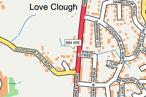
BB4 8RE lies on Rings Nook in Loveclough, Rossendale. BB4 8RE is located in the Goodshaw electoral ward, within the local authority district of Rossendale and the English Parliamentary constituency of Rossendale and Darwen. The Sub Integrated Care Board (ICB) Location is NHS Lancashire and South Cumbria ICB - 01A and the police force is Lancashire. This postcode has been in use since December 1996.


GetTheData
Source: OS OpenMap – Local (Ordnance Survey)
Source: OS VectorMap District (Ordnance Survey)
Licence: Open Government Licence (requires attribution)
| Easting | 381134 |
| Northing | 426586 |
| Latitude | 53.735317 |
| Longitude | -2.287472 |
GetTheData
Source: Open Postcode Geo
Licence: Open Government Licence
| Street | Rings Nook |
| Locality | Loveclough |
| Town/City | Rossendale |
| Country | England |
| Postcode District | BB4 |
➜ See where BB4 is on a map ➜ Where is Rawtenstall? | |
GetTheData
Source: Land Registry Price Paid Data
Licence: Open Government Licence
Elevation or altitude of BB4 8RE as distance above sea level:
| Metres | Feet | |
|---|---|---|
| Elevation | 260m | 853ft |
Elevation is measured from the approximate centre of the postcode, to the nearest point on an OS contour line from OS Terrain 50, which has contour spacing of ten vertical metres.
➜ How high above sea level am I? Find the elevation of your current position using your device's GPS.
GetTheData
Source: Open Postcode Elevation
Licence: Open Government Licence
| Ward | Goodshaw |
| Constituency | Rossendale And Darwen |
GetTheData
Source: ONS Postcode Database
Licence: Open Government Licence
1, RINGS NOOK, LOVECLOUGH, ROSSENDALE, BB4 8RE 2003 4 APR £154,000 |
GetTheData
Source: HM Land Registry Price Paid Data
Licence: Contains HM Land Registry data © Crown copyright and database right 2025. This data is licensed under the Open Government Licence v3.0.
| Goodshaw Fold Road (Burnley Road) | Loveclough | 44m |
| Goodshaw Fold Road (Burnley Road) | Loveclough | 76m |
| Goodshawfold Close (Goodshawfold Road) | Loveclough | 117m |
| Goodshaw Avenue (Burnley Road) | Loveclough | 198m |
| Goodshaw Avenue (Burnley Road) | Loveclough | 217m |
| Huncoat Station | 5.7km |
GetTheData
Source: NaPTAN
Licence: Open Government Licence
| Percentage of properties with Next Generation Access | 100.0% |
| Percentage of properties with Superfast Broadband | 100.0% |
| Percentage of properties with Ultrafast Broadband | 0.0% |
| Percentage of properties with Full Fibre Broadband | 0.0% |
Superfast Broadband is between 30Mbps and 300Mbps
Ultrafast Broadband is > 300Mbps
| Percentage of properties unable to receive 2Mbps | 0.0% |
| Percentage of properties unable to receive 5Mbps | 0.0% |
| Percentage of properties unable to receive 10Mbps | 0.0% |
| Percentage of properties unable to receive 30Mbps | 0.0% |
GetTheData
Source: Ofcom
Licence: Ofcom Terms of Use (requires attribution)
GetTheData
Source: ONS Postcode Database
Licence: Open Government Licence


➜ Get more ratings from the Food Standards Agency
GetTheData
Source: Food Standards Agency
Licence: FSA terms & conditions
| Last Collection | |||
|---|---|---|---|
| Location | Mon-Fri | Sat | Distance |
| Rossendale Delivery Office | 17:45 | 13:00 | 3,728m |
| Newchurch Road | 17:30 | 11:30 | 3,999m |
| Railway Station | 16:45 | 12:30 | 4,049m |
GetTheData
Source: Dracos
Licence: Creative Commons Attribution-ShareAlike
The below table lists the International Territorial Level (ITL) codes (formerly Nomenclature of Territorial Units for Statistics (NUTS) codes) and Local Administrative Units (LAU) codes for BB4 8RE:
| ITL 1 Code | Name |
|---|---|
| TLD | North West (England) |
| ITL 2 Code | Name |
| TLD4 | Lancashire |
| ITL 3 Code | Name |
| TLD46 | East Lancashire |
| LAU 1 Code | Name |
| E07000125 | Rossendale |
GetTheData
Source: ONS Postcode Directory
Licence: Open Government Licence
The below table lists the Census Output Area (OA), Lower Layer Super Output Area (LSOA), and Middle Layer Super Output Area (MSOA) for BB4 8RE:
| Code | Name | |
|---|---|---|
| OA | E00128718 | |
| LSOA | E01025361 | Rossendale 001B |
| MSOA | E02005278 | Rossendale 001 |
GetTheData
Source: ONS Postcode Directory
Licence: Open Government Licence
| BB4 8PZ | Goodshaw Fold Close | 68m |
| BB4 8RY | Rings Street | 69m |
| BB4 8QL | Burnley Road | 75m |
| BB4 8RJ | Swinshaw Close | 123m |
| BB4 8QP | Primrose Cottages | 127m |
| BB4 8AB | Back Rings Row | 133m |
| BB4 8RH | Goodshaw Avenue North | 159m |
| BB4 8FE | Turf Meadow | 173m |
| BB4 8QN | Goodshawfold Road | 194m |
| BB4 8QH | Hamer Avenue | 194m |
GetTheData
Source: Open Postcode Geo; Land Registry Price Paid Data
Licence: Open Government Licence