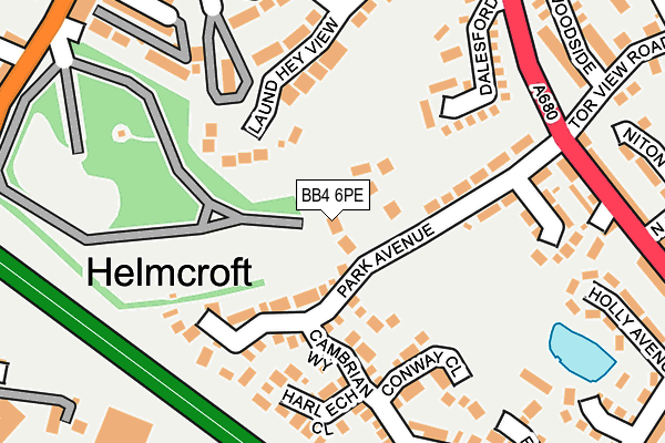
BB4 6PE lies on Parklands in Haslingden, Rossendale. BB4 6PE is located in the Greenfield electoral ward, within the local authority district of Rossendale and the English Parliamentary constituency of Hyndburn. The Sub Integrated Care Board (ICB) Location is NHS Lancashire and South Cumbria ICB - 01A and the police force is Lancashire. This postcode has been in use since January 1993.


GetTheData
Source: OS OpenMap – Local (Ordnance Survey)
Source: OS VectorMap District (Ordnance Survey)
Licence: Open Government Licence (requires attribution)
| Easting | 378824 |
| Northing | 422325 |
| Latitude | 53.696931 |
| Longitude | -2.322196 |
GetTheData
Source: Open Postcode Geo
Licence: Open Government Licence
| Street | Parklands |
| Locality | Haslingden |
| Town/City | Rossendale |
| Country | England |
| Postcode District | BB4 |
➜ See where BB4 is on a map ➜ Where is Haslingden? | |
GetTheData
Source: Land Registry Price Paid Data
Licence: Open Government Licence
Elevation or altitude of BB4 6PE as distance above sea level:
| Metres | Feet | |
|---|---|---|
| Elevation | 210m | 689ft |
Elevation is measured from the approximate centre of the postcode, to the nearest point on an OS contour line from OS Terrain 50, which has contour spacing of ten vertical metres.
➜ How high above sea level am I? Find the elevation of your current position using your device's GPS.
GetTheData
Source: Open Postcode Elevation
Licence: Open Government Licence
| Ward | Greenfield |
| Constituency | Hyndburn |
GetTheData
Source: ONS Postcode Database
Licence: Open Government Licence
6, PARKLANDS, HASLINGDEN, ROSSENDALE, BB4 6PE 2023 3 APR £540,000 |
6, PARKLANDS, HASLINGDEN, ROSSENDALE, BB4 6PE 2021 20 JAN £450,000 |
4, PARKLANDS, HASLINGDEN, ROSSENDALE, BB4 6PE 2020 17 APR £390,000 |
2010 1 OCT £345,000 |
2004 15 MAR £267,000 |
GetTheData
Source: HM Land Registry Price Paid Data
Licence: Contains HM Land Registry data © Crown copyright and database right 2025. This data is licensed under the Open Government Licence v3.0.
| Rose And Crown (Manchester Road) | Haslingden | 212m |
| Rose And Crown (Manchester Road) | Haslingden | 225m |
| South Street (Manchester Road) | Haslingden | 296m |
| Bender Factory (Manchester Road) | Haslingden | 300m |
| Whitecroft Ave (Helmshore Road) | Haslingden | 315m |
GetTheData
Source: NaPTAN
Licence: Open Government Licence
| Percentage of properties with Next Generation Access | 100.0% |
| Percentage of properties with Superfast Broadband | 100.0% |
| Percentage of properties with Ultrafast Broadband | 100.0% |
| Percentage of properties with Full Fibre Broadband | 0.0% |
Superfast Broadband is between 30Mbps and 300Mbps
Ultrafast Broadband is > 300Mbps
| Percentage of properties unable to receive 2Mbps | 0.0% |
| Percentage of properties unable to receive 5Mbps | 0.0% |
| Percentage of properties unable to receive 10Mbps | 0.0% |
| Percentage of properties unable to receive 30Mbps | 0.0% |
GetTheData
Source: Ofcom
Licence: Ofcom Terms of Use (requires attribution)
GetTheData
Source: ONS Postcode Database
Licence: Open Government Licence


➜ Get more ratings from the Food Standards Agency
GetTheData
Source: Food Standards Agency
Licence: FSA terms & conditions
| Last Collection | |||
|---|---|---|---|
| Location | Mon-Fri | Sat | Distance |
| Sidmouth Avenue | 17:30 | 12:15 | 449m |
| Haslingden Post Office | 17:15 | 12:00 | 883m |
| Railway Station | 16:45 | 12:30 | 2,138m |
GetTheData
Source: Dracos
Licence: Creative Commons Attribution-ShareAlike
The below table lists the International Territorial Level (ITL) codes (formerly Nomenclature of Territorial Units for Statistics (NUTS) codes) and Local Administrative Units (LAU) codes for BB4 6PE:
| ITL 1 Code | Name |
|---|---|
| TLD | North West (England) |
| ITL 2 Code | Name |
| TLD4 | Lancashire |
| ITL 3 Code | Name |
| TLD46 | East Lancashire |
| LAU 1 Code | Name |
| E07000125 | Rossendale |
GetTheData
Source: ONS Postcode Directory
Licence: Open Government Licence
The below table lists the Census Output Area (OA), Lower Layer Super Output Area (LSOA), and Middle Layer Super Output Area (MSOA) for BB4 6PE:
| Code | Name | |
|---|---|---|
| OA | E00128743 | |
| LSOA | E01025364 | Rossendale 002B |
| MSOA | E02005279 | Rossendale 002 |
GetTheData
Source: ONS Postcode Directory
Licence: Open Government Licence
| BB4 6PR | The Crescent | 40m |
| BB4 6PP | Park Avenue | 44m |
| BB4 6TG | Criccieth Close | 86m |
| BB4 4BB | Laund Hey View | 119m |
| BB4 6TN | Cambrian Way | 138m |
| BB4 6TL | Harlech Close | 160m |
| BB4 6TQ | Conway Close | 164m |
| BB4 6TF | Rhuddlan Close | 170m |
| BB4 6QH | Dalesford | 173m |
| BB4 6PS | Park Crescent | 185m |
GetTheData
Source: Open Postcode Geo; Land Registry Price Paid Data
Licence: Open Government Licence