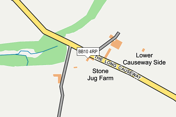
BB10 4RP lies on Long Causeway in Cliviger, Burnley. BB10 4RP is located in the Cliviger with Worsthorne electoral ward, within the local authority district of Burnley and the English Parliamentary constituency of Burnley. The Sub Integrated Care Board (ICB) Location is NHS Lancashire and South Cumbria ICB - 01A and the police force is Lancashire. This postcode has been in use since January 1980.


GetTheData
Source: OS OpenMap – Local (Ordnance Survey)
Source: OS VectorMap District (Ordnance Survey)
Licence: Open Government Licence (requires attribution)
| Easting | 388144 |
| Northing | 429723 |
| Latitude | 53.763721 |
| Longitude | -2.181328 |
GetTheData
Source: Open Postcode Geo
Licence: Open Government Licence
| Street | Long Causeway |
| Locality | Cliviger |
| Town/City | Burnley |
| Country | England |
| Postcode District | BB10 |
➜ See where BB10 is on a map | |
GetTheData
Source: Land Registry Price Paid Data
Licence: Open Government Licence
Elevation or altitude of BB10 4RP as distance above sea level:
| Metres | Feet | |
|---|---|---|
| Elevation | 290m | 951ft |
Elevation is measured from the approximate centre of the postcode, to the nearest point on an OS contour line from OS Terrain 50, which has contour spacing of ten vertical metres.
➜ How high above sea level am I? Find the elevation of your current position using your device's GPS.
GetTheData
Source: Open Postcode Elevation
Licence: Open Government Licence
| Ward | Cliviger With Worsthorne |
| Constituency | Burnley |
GetTheData
Source: ONS Postcode Database
Licence: Open Government Licence
| Mount Lane (Red Lees Road) | Over Town | 1,016m |
| Mount Lane (Red Lees Road) | Over Town | 1,027m |
| Moorland View (Red Lees Road) | Over Town | 1,034m |
| Mereclough Brow (Red Lees Road) | Over Town | 1,039m |
| Mount Crescent (Mount Lane) | Over Town | 1,075m |
| Burnley Manchester Road Station | 5km |
| Burnley Central Station | 5.3km |
GetTheData
Source: NaPTAN
Licence: Open Government Licence
| Percentage of properties with Next Generation Access | 100.0% |
| Percentage of properties with Superfast Broadband | 0.0% |
| Percentage of properties with Ultrafast Broadband | 0.0% |
| Percentage of properties with Full Fibre Broadband | 0.0% |
Superfast Broadband is between 30Mbps and 300Mbps
Ultrafast Broadband is > 300Mbps
| Percentage of properties unable to receive 2Mbps | 0.0% |
| Percentage of properties unable to receive 5Mbps | 0.0% |
| Percentage of properties unable to receive 10Mbps | 0.0% |
| Percentage of properties unable to receive 30Mbps | 100.0% |
GetTheData
Source: Ofcom
Licence: Ofcom Terms of Use (requires attribution)
GetTheData
Source: ONS Postcode Database
Licence: Open Government Licence


➜ Get more ratings from the Food Standards Agency
GetTheData
Source: Food Standards Agency
Licence: FSA terms & conditions
| Last Collection | |||
|---|---|---|---|
| Location | Mon-Fri | Sat | Distance |
| Walk Mill Post Office | 18:00 | 09:00 | 1,673m |
| Portsmouth P.o. | 17:00 | 11:30 | 3,411m |
| Daisy Bank | 17:00 | 11:30 | 4,041m |
GetTheData
Source: Dracos
Licence: Creative Commons Attribution-ShareAlike
The below table lists the International Territorial Level (ITL) codes (formerly Nomenclature of Territorial Units for Statistics (NUTS) codes) and Local Administrative Units (LAU) codes for BB10 4RP:
| ITL 1 Code | Name |
|---|---|
| TLD | North West (England) |
| ITL 2 Code | Name |
| TLD4 | Lancashire |
| ITL 3 Code | Name |
| TLD46 | East Lancashire |
| LAU 1 Code | Name |
| E07000117 | Burnley |
GetTheData
Source: ONS Postcode Directory
Licence: Open Government Licence
The below table lists the Census Output Area (OA), Lower Layer Super Output Area (LSOA), and Middle Layer Super Output Area (MSOA) for BB10 4RP:
| Code | Name | |
|---|---|---|
| OA | E00126227 | |
| LSOA | E01024870 | Burnley 009D |
| MSOA | E02005184 | Burnley 009 |
GetTheData
Source: ONS Postcode Directory
Licence: Open Government Licence
| BB10 4RW | Long Causeway | 679m |
| BB10 4RN | The Long Causeway | 850m |
| BB10 4RH | Greencliffe Lane | 926m |
| BB10 4RJ | School Lane | 941m |
| BB10 4TQ | Spring View | 981m |
| BB10 4TF | Red Lees Road | 994m |
| BB10 4TH | Scholey Head Lane | 997m |
| BB10 4TG | West View | 1009m |
| BB10 4RS | Foxstones Lane | 1027m |
| BB10 4TE | Sunnyfield Avenue | 1030m |
GetTheData
Source: Open Postcode Geo; Land Registry Price Paid Data
Licence: Open Government Licence