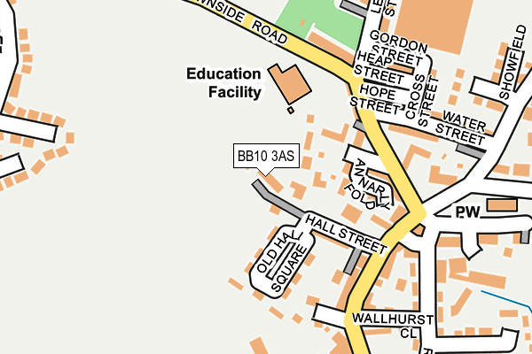
BB10 3AS lies on Meadowside in Worsthorne, Burnley. BB10 3AS is located in the Cliviger with Worsthorne electoral ward, within the local authority district of Burnley and the English Parliamentary constituency of Burnley. The Sub Integrated Care Board (ICB) Location is NHS Lancashire and South Cumbria ICB - 01A and the police force is Lancashire. This postcode has been in use since September 2009.


GetTheData
Source: OS OpenMap – Local (Ordnance Survey)
Source: OS VectorMap District (Ordnance Survey)
Licence: Open Government Licence (requires attribution)
| Easting | 387366 |
| Northing | 432437 |
| Latitude | 53.788110 |
| Longitude | -2.193243 |
GetTheData
Source: Open Postcode Geo
Licence: Open Government Licence
| Street | Meadowside |
| Locality | Worsthorne |
| Town/City | Burnley |
| Country | England |
| Postcode District | BB10 |
➜ See where BB10 is on a map ➜ Where is Worsthorne? | |
GetTheData
Source: Land Registry Price Paid Data
Licence: Open Government Licence
Elevation or altitude of BB10 3AS as distance above sea level:
| Metres | Feet | |
|---|---|---|
| Elevation | 210m | 689ft |
Elevation is measured from the approximate centre of the postcode, to the nearest point on an OS contour line from OS Terrain 50, which has contour spacing of ten vertical metres.
➜ How high above sea level am I? Find the elevation of your current position using your device's GPS.
GetTheData
Source: Open Postcode Elevation
Licence: Open Government Licence
| Ward | Cliviger With Worsthorne |
| Constituency | Burnley |
GetTheData
Source: ONS Postcode Database
Licence: Open Government Licence
| Primary School (Brownside Road) | Worsthorne | 152m |
| Primary School (Brownside Road) | Worsthorne | 152m |
| Church Square (Ormerod Street) | Worsthorne | 183m |
| Heckenhurst Avenue (Brownside Road) | Worsthorne | 337m |
| Heckenhurst Avenue (Brownside Road) | Brownside | 380m |
| Burnley Central Station | 3.5km |
| Burnley Manchester Road Station | 3.7km |
| Burnley Barracks Station | 4.3km |
GetTheData
Source: NaPTAN
Licence: Open Government Licence
| Percentage of properties with Next Generation Access | 100.0% |
| Percentage of properties with Superfast Broadband | 100.0% |
| Percentage of properties with Ultrafast Broadband | 71.4% |
| Percentage of properties with Full Fibre Broadband | 0.0% |
Superfast Broadband is between 30Mbps and 300Mbps
Ultrafast Broadband is > 300Mbps
| Median download speed | 150.0Mbps |
| Average download speed | 164.0Mbps |
| Maximum download speed | 350.00Mbps |
Ofcom does not currently provide upload speed data for BB10 3AS. This is because there are less than four broadband connections in this postcode.
| Percentage of properties unable to receive 2Mbps | 0.0% |
| Percentage of properties unable to receive 5Mbps | 0.0% |
| Percentage of properties unable to receive 10Mbps | 0.0% |
| Percentage of properties unable to receive 30Mbps | 0.0% |
GetTheData
Source: Ofcom
Licence: Ofcom Terms of Use (requires attribution)
GetTheData
Source: ONS Postcode Database
Licence: Open Government Licence


➜ Get more ratings from the Food Standards Agency
GetTheData
Source: Food Standards Agency
Licence: FSA terms & conditions
| Last Collection | |||
|---|---|---|---|
| Location | Mon-Fri | Sat | Distance |
| Walk Mill Post Office | 18:00 | 09:00 | 2,590m |
| Briercliffe Road | 17:30 | 11:00 | 2,995m |
| Brunshaw Top | 16:00 | 11:00 | 3,237m |
GetTheData
Source: Dracos
Licence: Creative Commons Attribution-ShareAlike
The below table lists the International Territorial Level (ITL) codes (formerly Nomenclature of Territorial Units for Statistics (NUTS) codes) and Local Administrative Units (LAU) codes for BB10 3AS:
| ITL 1 Code | Name |
|---|---|
| TLD | North West (England) |
| ITL 2 Code | Name |
| TLD4 | Lancashire |
| ITL 3 Code | Name |
| TLD46 | East Lancashire |
| LAU 1 Code | Name |
| E07000117 | Burnley |
GetTheData
Source: ONS Postcode Directory
Licence: Open Government Licence
The below table lists the Census Output Area (OA), Lower Layer Super Output Area (LSOA), and Middle Layer Super Output Area (MSOA) for BB10 3AS:
| Code | Name | |
|---|---|---|
| OA | E00126231 | |
| LSOA | E01024868 | Burnley 009B |
| MSOA | E02005184 | Burnley 009 |
GetTheData
Source: ONS Postcode Directory
Licence: Open Government Licence
| BB10 3LX | The Crescent | 61m |
| BB10 3LU | Mount Pleasant | 112m |
| BB10 3NS | Old Hall Square | 121m |
| BB10 3LS | Halstead Street | 128m |
| BB10 3AB | Annarly Fold | 129m |
| BB10 3NR | Chapel Street | 134m |
| BB10 3NG | The Square | 164m |
| BB10 3LR | Brownside Road | 165m |
| BB10 3LT | Hope Street | 183m |
| BB10 3NE | Heap Street | 186m |
GetTheData
Source: Open Postcode Geo; Land Registry Price Paid Data
Licence: Open Government Licence