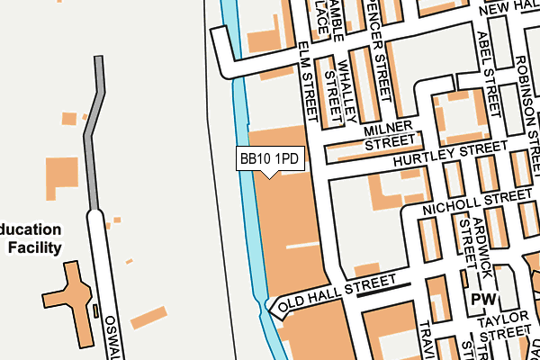
BB10 1PD is located in the Daneshouse with Stoneyholme electoral ward, within the local authority district of Burnley and the English Parliamentary constituency of Burnley. The Sub Integrated Care Board (ICB) Location is NHS Lancashire and South Cumbria ICB - 01A and the police force is Lancashire. This postcode has been in use since January 1980.


GetTheData
Source: OS OpenMap – Local (Ordnance Survey)
Source: OS VectorMap District (Ordnance Survey)
Licence: Open Government Licence (requires attribution)
| Easting | 384032 |
| Northing | 433902 |
| Latitude | 53.801170 |
| Longitude | -2.243922 |
GetTheData
Source: Open Postcode Geo
Licence: Open Government Licence
| Country | England |
| Postcode District | BB10 |
➜ See where BB10 is on a map ➜ Where is Burnley? | |
GetTheData
Source: Land Registry Price Paid Data
Licence: Open Government Licence
Elevation or altitude of BB10 1PD as distance above sea level:
| Metres | Feet | |
|---|---|---|
| Elevation | 130m | 427ft |
Elevation is measured from the approximate centre of the postcode, to the nearest point on an OS contour line from OS Terrain 50, which has contour spacing of ten vertical metres.
➜ How high above sea level am I? Find the elevation of your current position using your device's GPS.
GetTheData
Source: Open Postcode Elevation
Licence: Open Government Licence
| Ward | Daneshouse With Stoneyholme |
| Constituency | Burnley |
GetTheData
Source: ONS Postcode Database
Licence: Open Government Licence
| Nicholl Street (Abel Street) | Stoneyholme | 254m |
| Nicholl Street (Abel Street) | Stoneyholme | 263m |
| Taylor Street (Abel Street) | Stoneyholme | 317m |
| The Dragon (Hebrew Road) | Stoneyholme | 339m |
| Robinson Street (New Hall Street) | Duke Bar | 340m |
| Burnley Central Station | 0.9km |
| Burnley Barracks Station | 1.5km |
| Burnley Manchester Road Station | 1.8km |
GetTheData
Source: NaPTAN
Licence: Open Government Licence
GetTheData
Source: ONS Postcode Database
Licence: Open Government Licence


➜ Get more ratings from the Food Standards Agency
GetTheData
Source: Food Standards Agency
Licence: FSA terms & conditions
| Last Collection | |||
|---|---|---|---|
| Location | Mon-Fri | Sat | Distance |
| Brunshaw Top | 16:00 | 11:00 | 535m |
| 340 Colne Road | 17:30 | 11:00 | 836m |
| Bank Top | 17:30 | 11:00 | 1,000m |
GetTheData
Source: Dracos
Licence: Creative Commons Attribution-ShareAlike
The below table lists the International Territorial Level (ITL) codes (formerly Nomenclature of Territorial Units for Statistics (NUTS) codes) and Local Administrative Units (LAU) codes for BB10 1PD:
| ITL 1 Code | Name |
|---|---|
| TLD | North West (England) |
| ITL 2 Code | Name |
| TLD4 | Lancashire |
| ITL 3 Code | Name |
| TLD46 | East Lancashire |
| LAU 1 Code | Name |
| E07000117 | Burnley |
GetTheData
Source: ONS Postcode Directory
Licence: Open Government Licence
The below table lists the Census Output Area (OA), Lower Layer Super Output Area (LSOA), and Middle Layer Super Output Area (MSOA) for BB10 1PD:
| Code | Name | |
|---|---|---|
| OA | E00126264 | |
| LSOA | E01024878 | Burnley 003E |
| MSOA | E02005178 | Burnley 003 |
GetTheData
Source: ONS Postcode Directory
Licence: Open Government Licence
| BB10 1PG | Elm Street | 110m |
| BB10 1BX | Whalley Street | 121m |
| BB10 1BT | Milner Street | 127m |
| BB10 1BY | Hurtley Street | 134m |
| BB10 1BU | Spencer Street | 177m |
| BB10 1DB | Travis Street | 181m |
| BB10 1PS | New Hall Street | 187m |
| BB10 1PH | Elm Street | 190m |
| BB10 1BZ | Grey Street | 194m |
| BB10 1DA | Old Hall Street | 195m |
GetTheData
Source: Open Postcode Geo; Land Registry Price Paid Data
Licence: Open Government Licence