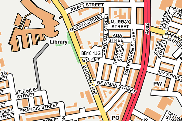
BB10 1JG lies on Bright Street in Burnley. BB10 1JG is located in the Queensgate electoral ward, within the local authority district of Burnley and the English Parliamentary constituency of Burnley. The Sub Integrated Care Board (ICB) Location is NHS Lancashire and South Cumbria ICB - 01A and the police force is Lancashire. This postcode has been in use since January 1980.


GetTheData
Source: OS OpenMap – Local (Ordnance Survey)
Source: OS VectorMap District (Ordnance Survey)
Licence: Open Government Licence (requires attribution)
| Easting | 384504 |
| Northing | 434306 |
| Latitude | 53.804816 |
| Longitude | -2.236777 |
GetTheData
Source: Open Postcode Geo
Licence: Open Government Licence
| Street | Bright Street |
| Town/City | Burnley |
| Country | England |
| Postcode District | BB10 |
➜ See where BB10 is on a map ➜ Where is Burnley? | |
GetTheData
Source: Land Registry Price Paid Data
Licence: Open Government Licence
Elevation or altitude of BB10 1JG as distance above sea level:
| Metres | Feet | |
|---|---|---|
| Elevation | 140m | 459ft |
Elevation is measured from the approximate centre of the postcode, to the nearest point on an OS contour line from OS Terrain 50, which has contour spacing of ten vertical metres.
➜ How high above sea level am I? Find the elevation of your current position using your device's GPS.
GetTheData
Source: Open Postcode Elevation
Licence: Open Government Licence
| Ward | Queensgate |
| Constituency | Burnley |
GetTheData
Source: ONS Postcode Database
Licence: Open Government Licence
| New Hall Street (Barden Lane) | Duke Bar | 167m |
| Newman Street (Colne Road) | Duke Bar | 188m |
| Newman Street (Colne Road) | Duke Bar | 200m |
| New Hall Street (Hilary Street) | Duke Bar | 203m |
| Murray Street (Colne Road) | Queensgate | 222m |
| Burnley Central Station | 1.4km |
| Burnley Barracks Station | 2.1km |
| Brierfield Station | 2.1km |
GetTheData
Source: NaPTAN
Licence: Open Government Licence
GetTheData
Source: ONS Postcode Database
Licence: Open Government Licence


➜ Get more ratings from the Food Standards Agency
GetTheData
Source: Food Standards Agency
Licence: FSA terms & conditions
| Last Collection | |||
|---|---|---|---|
| Location | Mon-Fri | Sat | Distance |
| 340 Colne Road | 17:30 | 11:00 | 219m |
| Brunshaw Top | 16:00 | 11:00 | 902m |
| Bank Top | 17:30 | 11:00 | 1,465m |
GetTheData
Source: Dracos
Licence: Creative Commons Attribution-ShareAlike
The below table lists the International Territorial Level (ITL) codes (formerly Nomenclature of Territorial Units for Statistics (NUTS) codes) and Local Administrative Units (LAU) codes for BB10 1JG:
| ITL 1 Code | Name |
|---|---|
| TLD | North West (England) |
| ITL 2 Code | Name |
| TLD4 | Lancashire |
| ITL 3 Code | Name |
| TLD46 | East Lancashire |
| LAU 1 Code | Name |
| E07000117 | Burnley |
GetTheData
Source: ONS Postcode Directory
Licence: Open Government Licence
The below table lists the Census Output Area (OA), Lower Layer Super Output Area (LSOA), and Middle Layer Super Output Area (MSOA) for BB10 1JG:
| Code | Name | |
|---|---|---|
| OA | E00126356 | |
| LSOA | E01024895 | Burnley 003F |
| MSOA | E02005178 | Burnley 003 |
GetTheData
Source: ONS Postcode Directory
Licence: Open Government Licence
| BB10 1JF | Barden Lane | 19m |
| BB10 1RX | Bright Street | 50m |
| BB10 1RU | Cardinal Street | 55m |
| BB10 1JR | Haslam Court | 60m |
| BB10 1RT | Redvers Street | 65m |
| BB10 1RY | Cardinal Street | 110m |
| BB10 1RP | Waterbarn Street | 112m |
| BB10 1RW | Newman Street | 113m |
| BB10 1RS | Ada Street | 123m |
| BB10 1RR | Bright Street | 138m |
GetTheData
Source: Open Postcode Geo; Land Registry Price Paid Data
Licence: Open Government Licence