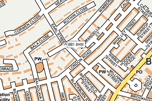
BB1 8HW is located in the Bastwell & Daisyfield electoral ward, within the unitary authority of Blackburn with Darwen and the English Parliamentary constituency of Blackburn. The Sub Integrated Care Board (ICB) Location is NHS Lancashire and South Cumbria ICB - 00Q and the police force is Lancashire. This postcode has been in use since January 1995.


GetTheData
Source: OS OpenMap – Local (Ordnance Survey)
Source: OS VectorMap District (Ordnance Survey)
Licence: Open Government Licence (requires attribution)
| Easting | 368328 |
| Northing | 428923 |
| Latitude | 53.755713 |
| Longitude | -2.481833 |
GetTheData
Source: Open Postcode Geo
Licence: Open Government Licence
| Country | England |
| Postcode District | BB1 |
➜ See where BB1 is on a map ➜ Where is Blackburn? | |
GetTheData
Source: Land Registry Price Paid Data
Licence: Open Government Licence
Elevation or altitude of BB1 8HW as distance above sea level:
| Metres | Feet | |
|---|---|---|
| Elevation | 150m | 492ft |
Elevation is measured from the approximate centre of the postcode, to the nearest point on an OS contour line from OS Terrain 50, which has contour spacing of ten vertical metres.
➜ How high above sea level am I? Find the elevation of your current position using your device's GPS.
GetTheData
Source: Open Postcode Elevation
Licence: Open Government Licence
| Ward | Bastwell & Daisyfield |
| Constituency | Blackburn |
GetTheData
Source: ONS Postcode Database
Licence: Open Government Licence
| London Road | Blackburn | 48m |
| Marsh Street (Wimberley Street) | Brookhouse | 49m |
| Marsh Street (Wimberley Street) | Blackburn | 73m |
| Whalley Range | Blackburn | 245m |
| Victoria St (Whalley Range) | Blackburn | 290m |
| Blackburn Station | 1km |
| Mill Hill (Lancs) Station | 2.6km |
| Ramsgreave & Wilpshire Station | 2.7km |
GetTheData
Source: NaPTAN
Licence: Open Government Licence
| Percentage of properties with Next Generation Access | 100.0% |
| Percentage of properties with Superfast Broadband | 100.0% |
| Percentage of properties with Ultrafast Broadband | 0.0% |
| Percentage of properties with Full Fibre Broadband | 0.0% |
Superfast Broadband is between 30Mbps and 300Mbps
Ultrafast Broadband is > 300Mbps
| Percentage of properties unable to receive 2Mbps | 0.0% |
| Percentage of properties unable to receive 5Mbps | 0.0% |
| Percentage of properties unable to receive 10Mbps | 0.0% |
| Percentage of properties unable to receive 30Mbps | 0.0% |
GetTheData
Source: Ofcom
Licence: Ofcom Terms of Use (requires attribution)
GetTheData
Source: ONS Postcode Database
Licence: Open Government Licence


➜ Get more ratings from the Food Standards Agency
GetTheData
Source: Food Standards Agency
Licence: FSA terms & conditions
| Last Collection | |||
|---|---|---|---|
| Location | Mon-Fri | Sat | Distance |
| Shear Brow | 16:45 | 12:00 | 526m |
| Technical College | 16:00 | 11:15 | 811m |
| Church Street | 16:30 | 13:00 | 846m |
GetTheData
Source: Dracos
Licence: Creative Commons Attribution-ShareAlike
The below table lists the International Territorial Level (ITL) codes (formerly Nomenclature of Territorial Units for Statistics (NUTS) codes) and Local Administrative Units (LAU) codes for BB1 8HW:
| ITL 1 Code | Name |
|---|---|
| TLD | North West (England) |
| ITL 2 Code | Name |
| TLD4 | Lancashire |
| ITL 3 Code | Name |
| TLD41 | Blackburn with Darwen |
| LAU 1 Code | Name |
| E06000008 | Blackburn with Darwen |
GetTheData
Source: ONS Postcode Directory
Licence: Open Government Licence
The below table lists the Census Output Area (OA), Lower Layer Super Output Area (LSOA), and Middle Layer Super Output Area (MSOA) for BB1 8HW:
| Code | Name | |
|---|---|---|
| OA | E00063432 | |
| LSOA | E01012580 | Blackburn with Darwen 004B |
| MSOA | E02002618 | Blackburn with Darwen 004 |
GetTheData
Source: ONS Postcode Directory
Licence: Open Government Licence
| BB1 7NH | London Walk | 44m |
| BB1 8HX | Wimberley Street | 69m |
| BB1 7NB | Whalley Street | 74m |
| BB1 7LR | London Road | 81m |
| BB1 7LT | Mandela Court | 124m |
| BB1 7NA | London Road | 136m |
| BB1 8HY | Ruthin Close | 138m |
| BB1 7ND | Earl Street | 149m |
| BB1 6EU | Millham Street | 155m |
| BB1 8JA | Bala Close | 157m |
GetTheData
Source: Open Postcode Geo; Land Registry Price Paid Data
Licence: Open Government Licence