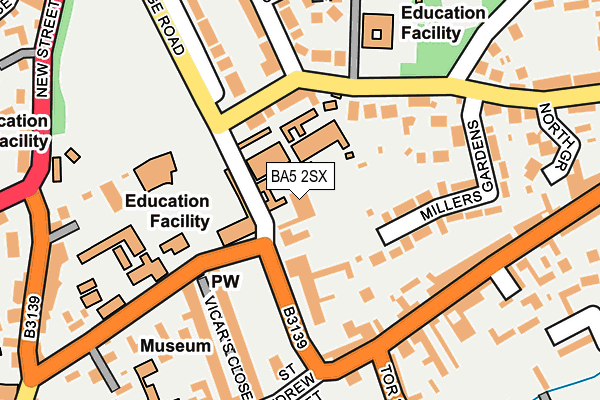
BA5 2SX is located in the Wells electoral ward, within the unitary authority of Somerset and the English Parliamentary constituency of Wells. The Sub Integrated Care Board (ICB) Location is NHS Somerset ICB - 11X and the police force is Avon and Somerset. This postcode has been in use since January 1980.


GetTheData
Source: OS OpenMap – Local (Ordnance Survey)
Source: OS VectorMap District (Ordnance Survey)
Licence: Open Government Licence (requires attribution)
| Easting | 355210 |
| Northing | 146150 |
| Latitude | 51.212786 |
| Longitude | -2.642614 |
GetTheData
Source: Open Postcode Geo
Licence: Open Government Licence
| Country | England |
| Postcode District | BA5 |
➜ See where BA5 is on a map ➜ Where is Wells? | |
GetTheData
Source: Land Registry Price Paid Data
Licence: Open Government Licence
Elevation or altitude of BA5 2SX as distance above sea level:
| Metres | Feet | |
|---|---|---|
| Elevation | 60m | 197ft |
Elevation is measured from the approximate centre of the postcode, to the nearest point on an OS contour line from OS Terrain 50, which has contour spacing of ten vertical metres.
➜ How high above sea level am I? Find the elevation of your current position using your device's GPS.
GetTheData
Source: Open Postcode Elevation
Licence: Open Government Licence
| Ward | Wells |
| Constituency | Wells |
GetTheData
Source: ONS Postcode Database
Licence: Open Government Licence
| Chip Shop | Wells | 172m |
| Chip Shop (St Thomas Street) | Wells | 176m |
| The Liberty | Wells | 237m |
| The Liberty | Wells | 262m |
| New Street | Wells | 265m |
GetTheData
Source: NaPTAN
Licence: Open Government Licence
GetTheData
Source: ONS Postcode Database
Licence: Open Government Licence


➜ Get more ratings from the Food Standards Agency
GetTheData
Source: Food Standards Agency
Licence: FSA terms & conditions
| Last Collection | |||
|---|---|---|---|
| Location | Mon-Fri | Sat | Distance |
| Wells Post Office | 17:30 | 12:30 | 386m |
| High Street | 17:30 | 12:30 | 508m |
| Woodbury Avenue | 17:00 | 12:00 | 641m |
GetTheData
Source: Dracos
Licence: Creative Commons Attribution-ShareAlike
The below table lists the International Territorial Level (ITL) codes (formerly Nomenclature of Territorial Units for Statistics (NUTS) codes) and Local Administrative Units (LAU) codes for BA5 2SX:
| ITL 1 Code | Name |
|---|---|
| TLK | South West (England) |
| ITL 2 Code | Name |
| TLK2 | Dorset and Somerset |
| ITL 3 Code | Name |
| TLK23 | Somerset CC |
| LAU 1 Code | Name |
| E07000187 | Mendip |
GetTheData
Source: ONS Postcode Directory
Licence: Open Government Licence
The below table lists the Census Output Area (OA), Lower Layer Super Output Area (LSOA), and Middle Layer Super Output Area (MSOA) for BA5 2SX:
| Code | Name | |
|---|---|---|
| OA | E00148124 | |
| LSOA | E01029083 | Mendip 005D |
| MSOA | E02006051 | Mendip 005 |
GetTheData
Source: ONS Postcode Directory
Licence: Open Government Licence
| BA5 2TJ | North Road | 105m |
| BA5 2TW | Millers Gardens | 151m |
| BA5 2UW | St Andrews Street | 161m |
| BA5 2UU | St Thomas Street | 162m |
| BA5 2SS | The Liberty | 170m |
| BA5 2UX | St Thomas Street | 181m |
| BA5 2UR | St Andrews Street | 182m |
| BA5 2TF | Stoberry Avenue | 191m |
| BA5 2XE | Wood View | 193m |
| BA5 2TN | Millers Gardens | 206m |
GetTheData
Source: Open Postcode Geo; Land Registry Price Paid Data
Licence: Open Government Licence