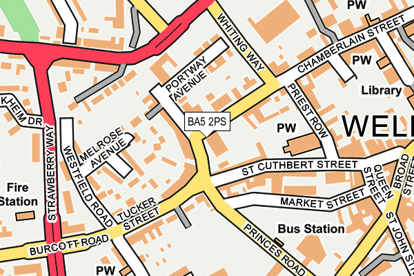
BA5 2PS is located in the Wells electoral ward, within the unitary authority of Somerset and the English Parliamentary constituency of Wells. The Sub Integrated Care Board (ICB) Location is NHS Somerset ICB - 11X and the police force is Avon and Somerset. This postcode has been in use since January 1980.


GetTheData
Source: OS OpenMap – Local (Ordnance Survey)
Source: OS VectorMap District (Ordnance Survey)
Licence: Open Government Licence (requires attribution)
| Easting | 354532 |
| Northing | 145666 |
| Latitude | 51.208381 |
| Longitude | -2.652258 |
GetTheData
Source: Open Postcode Geo
Licence: Open Government Licence
| Country | England |
| Postcode District | BA5 |
➜ See where BA5 is on a map ➜ Where is Wells? | |
GetTheData
Source: Land Registry Price Paid Data
Licence: Open Government Licence
Elevation or altitude of BA5 2PS as distance above sea level:
| Metres | Feet | |
|---|---|---|
| Elevation | 40m | 131ft |
Elevation is measured from the approximate centre of the postcode, to the nearest point on an OS contour line from OS Terrain 50, which has contour spacing of ten vertical metres.
➜ How high above sea level am I? Find the elevation of your current position using your device's GPS.
GetTheData
Source: Open Postcode Elevation
Licence: Open Government Licence
| Ward | Wells |
| Constituency | Wells |
GetTheData
Source: ONS Postcode Database
Licence: Open Government Licence
| Chamberlain Street | Wells | 90m |
| Bubwith House (Chamberlain Street) | Wells | 93m |
| The Old Wheelwright Cottages (Portway) | Wells | 211m |
| The Portway (Portway) | Wells | 230m |
| Mill Lane (High Street) | Wells | 308m |
GetTheData
Source: NaPTAN
Licence: Open Government Licence
GetTheData
Source: ONS Postcode Database
Licence: Open Government Licence


➜ Get more ratings from the Food Standards Agency
GetTheData
Source: Food Standards Agency
Licence: FSA terms & conditions
| Last Collection | |||
|---|---|---|---|
| Location | Mon-Fri | Sat | Distance |
| Tucker Street | 17:30 | 11:30 | 116m |
| Wells Delivery Office | 18:00 | 12:45 | 237m |
| Priory Road Post Office, Closed | 17:30 | 12:45 | 285m |
GetTheData
Source: Dracos
Licence: Creative Commons Attribution-ShareAlike
The below table lists the International Territorial Level (ITL) codes (formerly Nomenclature of Territorial Units for Statistics (NUTS) codes) and Local Administrative Units (LAU) codes for BA5 2PS:
| ITL 1 Code | Name |
|---|---|
| TLK | South West (England) |
| ITL 2 Code | Name |
| TLK2 | Dorset and Somerset |
| ITL 3 Code | Name |
| TLK23 | Somerset CC |
| LAU 1 Code | Name |
| E07000187 | Mendip |
GetTheData
Source: ONS Postcode Directory
Licence: Open Government Licence
The below table lists the Census Output Area (OA), Lower Layer Super Output Area (LSOA), and Middle Layer Super Output Area (MSOA) for BA5 2PS:
| Code | Name | |
|---|---|---|
| OA | E00148100 | |
| LSOA | E01029078 | Mendip 008A |
| MSOA | E02006054 | Mendip 008 |
GetTheData
Source: ONS Postcode Directory
Licence: Open Government Licence
| BA5 2BD | Portway | 48m |
| BA5 2BE | Portway | 59m |
| BA5 2BA | Portway | 71m |
| BA5 2DT | Princes Road | 90m |
| BA5 2AW | St Cuthbert Street | 92m |
| BA5 2PT | Chamberlain Street | 94m |
| BA5 2DZ | Tucker Street | 114m |
| BA5 2QF | Portway Avenue | 126m |
| BA5 2HT | Melrose Avenue | 141m |
| BA5 2DS | Market Street | 154m |
GetTheData
Source: Open Postcode Geo; Land Registry Price Paid Data
Licence: Open Government Licence