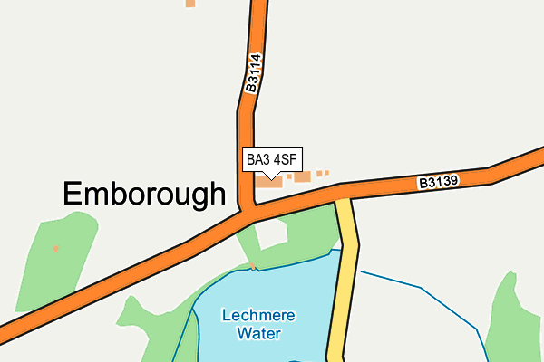
BA3 4SF lies on Ponds View in Emborough, Radstock. BA3 4SF is located in the Mendip Hills electoral ward, within the unitary authority of Somerset and the English Parliamentary constituency of Wells. The Sub Integrated Care Board (ICB) Location is NHS Somerset ICB - 11X and the police force is Avon and Somerset. This postcode has been in use since January 1980.


GetTheData
Source: OS OpenMap – Local (Ordnance Survey)
Source: OS VectorMap District (Ordnance Survey)
Licence: Open Government Licence (requires attribution)
| Easting | 361485 |
| Northing | 151117 |
| Latitude | 51.257906 |
| Longitude | -2.553319 |
GetTheData
Source: Open Postcode Geo
Licence: Open Government Licence
| Street | Ponds View |
| Locality | Emborough |
| Town/City | Radstock |
| Country | England |
| Postcode District | BA3 |
➜ See where BA3 is on a map ➜ Where is Emborough? | |
GetTheData
Source: Land Registry Price Paid Data
Licence: Open Government Licence
Elevation or altitude of BA3 4SF as distance above sea level:
| Metres | Feet | |
|---|---|---|
| Elevation | 210m | 689ft |
Elevation is measured from the approximate centre of the postcode, to the nearest point on an OS contour line from OS Terrain 50, which has contour spacing of ten vertical metres.
➜ How high above sea level am I? Find the elevation of your current position using your device's GPS.
GetTheData
Source: Open Postcode Elevation
Licence: Open Government Licence
| Ward | Mendip Hills |
| Constituency | Wells |
GetTheData
Source: ONS Postcode Database
Licence: Open Government Licence
| Old Down Camping Site | Old Down | 976m |
| Old Down Camping Site (Marchant's Hill) | Old Down | 1,000m |
| Old Down Inn | Old Down | 1,046m |
| Old Down Inn | Old Down | 1,048m |
| The Chalice | Old Down | 1,475m |
GetTheData
Source: NaPTAN
Licence: Open Government Licence
| Percentage of properties with Next Generation Access | 100.0% |
| Percentage of properties with Superfast Broadband | 0.0% |
| Percentage of properties with Ultrafast Broadband | 0.0% |
| Percentage of properties with Full Fibre Broadband | 0.0% |
Superfast Broadband is between 30Mbps and 300Mbps
Ultrafast Broadband is > 300Mbps
| Percentage of properties unable to receive 2Mbps | 0.0% |
| Percentage of properties unable to receive 5Mbps | 100.0% |
| Percentage of properties unable to receive 10Mbps | 100.0% |
| Percentage of properties unable to receive 30Mbps | 100.0% |
GetTheData
Source: Ofcom
Licence: Ofcom Terms of Use (requires attribution)
GetTheData
Source: ONS Postcode Database
Licence: Open Government Licence


➜ Get more ratings from the Food Standards Agency
GetTheData
Source: Food Standards Agency
Licence: FSA terms & conditions
| Last Collection | |||
|---|---|---|---|
| Location | Mon-Fri | Sat | Distance |
| Green Ore | 16:00 | 09:00 | 3,789m |
| Clevedon Road | 17:00 | 11:30 | 5,958m |
GetTheData
Source: Dracos
Licence: Creative Commons Attribution-ShareAlike
The below table lists the International Territorial Level (ITL) codes (formerly Nomenclature of Territorial Units for Statistics (NUTS) codes) and Local Administrative Units (LAU) codes for BA3 4SF:
| ITL 1 Code | Name |
|---|---|
| TLK | South West (England) |
| ITL 2 Code | Name |
| TLK2 | Dorset and Somerset |
| ITL 3 Code | Name |
| TLK23 | Somerset CC |
| LAU 1 Code | Name |
| E07000187 | Mendip |
GetTheData
Source: ONS Postcode Directory
Licence: Open Government Licence
The below table lists the Census Output Area (OA), Lower Layer Super Output Area (LSOA), and Middle Layer Super Output Area (MSOA) for BA3 4SF:
| Code | Name | |
|---|---|---|
| OA | E00147784 | |
| LSOA | E01029018 | Mendip 006A |
| MSOA | E02006052 | Mendip 006 |
GetTheData
Source: ONS Postcode Directory
Licence: Open Government Licence
| BA3 4SJ | Old Gore Lane | 714m |
| BA3 4SD | Mendip Villas | 745m |
| BA3 4SN | 1089m | |
| BA3 4TZ | Portway Lane | 1125m |
| BA3 4SA | 1165m | |
| BA3 4UA | Turners Court Lane | 1219m |
| BA3 4TY | Marchants Hill | 1310m |
| BA3 4SQ | Redhill Lane | 1349m |
| BA3 4UD | Dalleston | 1401m |
| BA3 4EG | Old Down Road | 1422m |
GetTheData
Source: Open Postcode Geo; Land Registry Price Paid Data
Licence: Open Government Licence