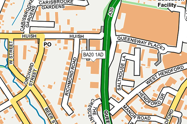
BA20 1AD is located in the Yeovil South electoral ward, within the unitary authority of Somerset and the English Parliamentary constituency of Yeovil. The Sub Integrated Care Board (ICB) Location is NHS Somerset ICB - 11X and the police force is Avon and Somerset. This postcode has been in use since January 1980.


GetTheData
Source: OS OpenMap – Local (Ordnance Survey)
Source: OS VectorMap District (Ordnance Survey)
Licence: Open Government Licence (requires attribution)
| Easting | 355181 |
| Northing | 115917 |
| Latitude | 50.940942 |
| Longitude | -2.639271 |
GetTheData
Source: Open Postcode Geo
Licence: Open Government Licence
| Country | England |
| Postcode District | BA20 |
➜ See where BA20 is on a map ➜ Where is Yeovil? | |
GetTheData
Source: Land Registry Price Paid Data
Licence: Open Government Licence
Elevation or altitude of BA20 1AD as distance above sea level:
| Metres | Feet | |
|---|---|---|
| Elevation | 50m | 164ft |
Elevation is measured from the approximate centre of the postcode, to the nearest point on an OS contour line from OS Terrain 50, which has contour spacing of ten vertical metres.
➜ How high above sea level am I? Find the elevation of your current position using your device's GPS.
GetTheData
Source: Open Postcode Elevation
Licence: Open Government Licence
| Ward | Yeovil South |
| Constituency | Yeovil |
GetTheData
Source: ONS Postcode Database
Licence: Open Government Licence
| Queensway Place Tesco (Queensway Place) | Yeovil | 175m |
| Beer Street | Yeovil | 213m |
| West Street | Yeovil | 260m |
| Seaton Road | Yeovil | 298m |
| Tesco (Clarence Street) | Yeovil | 323m |
| Yeovil Pen Mill Station | 1.9km |
| Yeovil Junction Station | 2.6km |
| Thornford Station | 5.4km |
GetTheData
Source: NaPTAN
Licence: Open Government Licence
GetTheData
Source: ONS Postcode Database
Licence: Open Government Licence


➜ Get more ratings from the Food Standards Agency
GetTheData
Source: Food Standards Agency
Licence: FSA terms & conditions
| Last Collection | |||
|---|---|---|---|
| Location | Mon-Fri | Sat | Distance |
| Yeovil Delivery Office | 18:00 | 12:00 | 70m |
| Orchard Street Post Office | 17:30 | 12:00 | 202m |
| Manor Road | 17:30 | 12:00 | 297m |
GetTheData
Source: Dracos
Licence: Creative Commons Attribution-ShareAlike
The below table lists the International Territorial Level (ITL) codes (formerly Nomenclature of Territorial Units for Statistics (NUTS) codes) and Local Administrative Units (LAU) codes for BA20 1AD:
| ITL 1 Code | Name |
|---|---|
| TLK | South West (England) |
| ITL 2 Code | Name |
| TLK2 | Dorset and Somerset |
| ITL 3 Code | Name |
| TLK23 | Somerset CC |
| LAU 1 Code | Name |
| E07000189 | South Somerset |
GetTheData
Source: ONS Postcode Directory
Licence: Open Government Licence
The below table lists the Census Output Area (OA), Lower Layer Super Output Area (LSOA), and Middle Layer Super Output Area (MSOA) for BA20 1AD:
| Code | Name | |
|---|---|---|
| OA | E00148967 | |
| LSOA | E01029241 | South Somerset 016A |
| MSOA | E02006090 | South Somerset 016 |
GetTheData
Source: ONS Postcode Directory
Licence: Open Government Licence
| BA20 1AG | Huish | 77m |
| BA20 1DT | Richmond Place | 90m |
| BA20 1AQ | Huish | 95m |
| BA20 1TY | Wellington Flats | 105m |
| BA20 1BH | Hallett Gardens | 108m |
| BA20 1DS | Richmond Place | 109m |
| BA20 1BA | Richmond Road | 121m |
| BA20 1TZ | Salthouse Lane | 121m |
| BA20 1BD | Huish | 132m |
| BA20 1TT | Salthouse Lane | 135m |
GetTheData
Source: Open Postcode Geo; Land Registry Price Paid Data
Licence: Open Government Licence