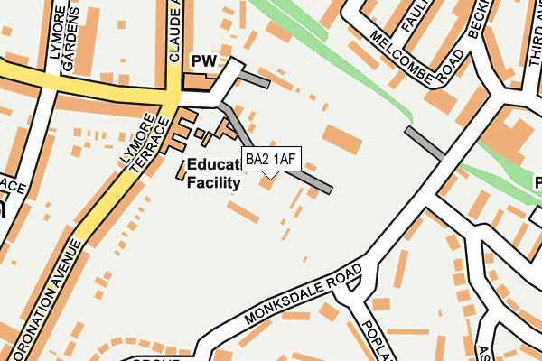
BA2 1AF is located in the Southdown electoral ward, within the unitary authority of Bath and North East Somerset and the English Parliamentary constituency of Bath. The Sub Integrated Care Board (ICB) Location is NHS Bath and North East Somerset, Swindon and Wiltshire ICB - 92 and the police force is Avon and Somerset. This postcode has been in use since January 1980.


GetTheData
Source: OS OpenMap – Local (Ordnance Survey)
Source: OS VectorMap District (Ordnance Survey)
Licence: Open Government Licence (requires attribution)
| Easting | 373559 |
| Northing | 163872 |
| Latitude | 51.373283 |
| Longitude | -2.381249 |
GetTheData
Source: Open Postcode Geo
Licence: Open Government Licence
| Country | England |
| Postcode District | BA2 |
➜ See where BA2 is on a map ➜ Where is Bath? | |
GetTheData
Source: Land Registry Price Paid Data
Licence: Open Government Licence
Elevation or altitude of BA2 1AF as distance above sea level:
| Metres | Feet | |
|---|---|---|
| Elevation | 50m | 164ft |
Elevation is measured from the approximate centre of the postcode, to the nearest point on an OS contour line from OS Terrain 50, which has contour spacing of ten vertical metres.
➜ How high above sea level am I? Find the elevation of your current position using your device's GPS.
GetTheData
Source: Open Postcode Elevation
Licence: Open Government Licence
| Ward | Southdown |
| Constituency | Bath |
GetTheData
Source: ONS Postcode Database
Licence: Open Government Licence
| Ascension Church (Coronation Avenue) | South Twerton | 138m |
| Ascension Church (Lymore Avenue) | South Twerton | 168m |
| Ascension Church (Claude Avenue) | South Twerton | 172m |
| Hillside Hall (Hillside Road) | Moorlands | 206m |
| Hillside Hall (Hillside Road) | Moorlands | 218m |
| Oldfield Park Station | 0.7km |
| Bath Spa Station | 1.8km |
GetTheData
Source: NaPTAN
Licence: Open Government Licence
GetTheData
Source: ONS Postcode Database
Licence: Open Government Licence


➜ Get more ratings from the Food Standards Agency
GetTheData
Source: Food Standards Agency
Licence: FSA terms & conditions
| Last Collection | |||
|---|---|---|---|
| Location | Mon-Fri | Sat | Distance |
| Poplar Close | 17:00 | 11:30 | 160m |
| Ivy Avenue | 17:15 | 13:00 | 379m |
| Third Avenue | 17:30 | 11:45 | 413m |
GetTheData
Source: Dracos
Licence: Creative Commons Attribution-ShareAlike
The below table lists the International Territorial Level (ITL) codes (formerly Nomenclature of Territorial Units for Statistics (NUTS) codes) and Local Administrative Units (LAU) codes for BA2 1AF:
| ITL 1 Code | Name |
|---|---|
| TLK | South West (England) |
| ITL 2 Code | Name |
| TLK1 | Gloucestershire, Wiltshire and Bath/Bristol area |
| ITL 3 Code | Name |
| TLK12 | Bath and North East Somerset, North Somerset and South Gloucestershire |
| LAU 1 Code | Name |
| E06000022 | Bath and North East Somerset |
GetTheData
Source: ONS Postcode Directory
Licence: Open Government Licence
The below table lists the Census Output Area (OA), Lower Layer Super Output Area (LSOA), and Middle Layer Super Output Area (MSOA) for BA2 1AF:
| Code | Name | |
|---|---|---|
| OA | E00072914 | |
| LSOA | E01014436 | Bath and North East Somerset 014B |
| MSOA | E02002998 | Bath and North East Somerset 014 |
GetTheData
Source: ONS Postcode Directory
Licence: Open Government Licence
| BA2 2JL | Lymore Terrace | 158m |
| BA2 2JD | Monksdale Road | 161m |
| BA2 3LP | Melcombe Road | 171m |
| BA2 2JB | Monksdale Road | 176m |
| BA2 2JT | Coronation Avenue | 180m |
| BA2 1BA | Lymore Avenue | 195m |
| BA2 2JN | Coronation Avenue | 197m |
| BA2 1AG | Claude Avenue | 198m |
| BA2 1AU | Lymore Avenue | 215m |
| BA2 1AE | Claude Avenue | 217m |
GetTheData
Source: Open Postcode Geo; Land Registry Price Paid Data
Licence: Open Government Licence