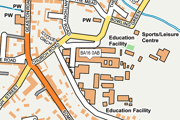
BA16 0AB is located in the Street electoral ward, within the unitary authority of Somerset and the English Parliamentary constituency of Wells. The Sub Integrated Care Board (ICB) Location is NHS Somerset ICB - 11X and the police force is Avon and Somerset. This postcode has been in use since January 1980.


GetTheData
Source: OS OpenMap – Local (Ordnance Survey)
Source: OS VectorMap District (Ordnance Survey)
Licence: Open Government Licence (requires attribution)
| Easting | 348733 |
| Northing | 137059 |
| Latitude | 51.130495 |
| Longitude | -2.734039 |
GetTheData
Source: Open Postcode Geo
Licence: Open Government Licence
| Country | England |
| Postcode District | BA16 |
➜ See where BA16 is on a map ➜ Where is Street? | |
GetTheData
Source: Land Registry Price Paid Data
Licence: Open Government Licence
Elevation or altitude of BA16 0AB as distance above sea level:
| Metres | Feet | |
|---|---|---|
| Elevation | 10m | 33ft |
Elevation is measured from the approximate centre of the postcode, to the nearest point on an OS contour line from OS Terrain 50, which has contour spacing of ten vertical metres.
➜ How high above sea level am I? Find the elevation of your current position using your device's GPS.
GetTheData
Source: Open Postcode Elevation
Licence: Open Government Licence
| Ward | Street |
| Constituency | Wells |
GetTheData
Source: ONS Postcode Database
Licence: Open Government Licence
| Strode College | Street | 55m |
| Strode College (Church Road) | Street | 73m |
| Strode College (Church Road) | Street | 81m |
| Glaston Road | Street | 140m |
| Glaston House (Glaston Road) | Street | 142m |
GetTheData
Source: NaPTAN
Licence: Open Government Licence
Estimated total energy consumption in BA16 0AB by fuel type, 2015.
| Consumption (kWh) | 142,217 |
|---|---|
| Meter count | 12 |
| Mean (kWh/meter) | 11,851 |
| Median (kWh/meter) | 5,660 |
GetTheData
Source: Postcode level gas estimates: 2015 (experimental)
Source: Postcode level electricity estimates: 2015 (experimental)
Licence: Open Government Licence
GetTheData
Source: ONS Postcode Database
Licence: Open Government Licence


➜ Get more ratings from the Food Standards Agency
GetTheData
Source: Food Standards Agency
Licence: FSA terms & conditions
| Last Collection | |||
|---|---|---|---|
| Location | Mon-Fri | Sat | Distance |
| The Cross | 16:00 | 11:30 | 86m |
| Strode Road | 16:00 | 11:30 | 502m |
| Clarks Village | 16:00 | 11:30 | 504m |
GetTheData
Source: Dracos
Licence: Creative Commons Attribution-ShareAlike
The below table lists the International Territorial Level (ITL) codes (formerly Nomenclature of Territorial Units for Statistics (NUTS) codes) and Local Administrative Units (LAU) codes for BA16 0AB:
| ITL 1 Code | Name |
|---|---|
| TLK | South West (England) |
| ITL 2 Code | Name |
| TLK2 | Dorset and Somerset |
| ITL 3 Code | Name |
| TLK23 | Somerset CC |
| LAU 1 Code | Name |
| E07000187 | Mendip |
GetTheData
Source: ONS Postcode Directory
Licence: Open Government Licence
The below table lists the Census Output Area (OA), Lower Layer Super Output Area (LSOA), and Middle Layer Super Output Area (MSOA) for BA16 0AB:
| Code | Name | |
|---|---|---|
| OA | E00148063 | |
| LSOA | E01029071 | Mendip 014B |
| MSOA | E02006060 | Mendip 014 |
GetTheData
Source: ONS Postcode Directory
Licence: Open Government Licence
| BA16 0AA | Church Road | 55m |
| BA16 0DX | Strode Road | 109m |
| BA16 0AE | Anthony Road | 116m |
| BA16 0FE | Somerton Road | 121m |
| BA16 0AN | Glaston Road | 138m |
| BA16 0AP | The Cross | 144m |
| BA16 0EB | High Street | 149m |
| BA16 0DU | Somerton Road | 156m |
| BA16 0AW | Glaston Road | 159m |
| BA16 0DR | Somerton Road | 160m |
GetTheData
Source: Open Postcode Geo; Land Registry Price Paid Data
Licence: Open Government Licence