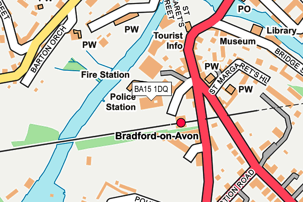
BA15 1DQ is located in the Bradford-on-Avon South electoral ward, within the unitary authority of Wiltshire and the English Parliamentary constituency of Chippenham. The Sub Integrated Care Board (ICB) Location is NHS Bath and North East Somerset, Swindon and Wiltshire ICB - 92 and the police force is Wiltshire. This postcode has been in use since January 1980.


GetTheData
Source: OS OpenMap – Local (Ordnance Survey)
Source: OS VectorMap District (Ordnance Survey)
Licence: Open Government Licence (requires attribution)
| Easting | 382466 |
| Northing | 160712 |
| Latitude | 51.345216 |
| Longitude | -2.253132 |
GetTheData
Source: Open Postcode Geo
Licence: Open Government Licence
| Country | England |
| Postcode District | BA15 |
➜ See where BA15 is on a map ➜ Where is Bradford-on-Avon? | |
GetTheData
Source: Land Registry Price Paid Data
Licence: Open Government Licence
Elevation or altitude of BA15 1DQ as distance above sea level:
| Metres | Feet | |
|---|---|---|
| Elevation | 30m | 98ft |
Elevation is measured from the approximate centre of the postcode, to the nearest point on an OS contour line from OS Terrain 50, which has contour spacing of ten vertical metres.
➜ How high above sea level am I? Find the elevation of your current position using your device's GPS.
GetTheData
Source: Open Postcode Elevation
Licence: Open Government Licence
| Ward | Bradford-on-avon South |
| Constituency | Chippenham |
GetTheData
Source: ONS Postcode Database
Licence: Open Government Licence
| Railway Station (Margaret's Sheet) | Bradford-on-avon | 54m |
| Railway Bridge (Frome Road) | Bradford-on-avon | 106m |
| United Church (St Margarets Street) | Bradford-on-avon | 120m |
| Town Bridge (Silver Street) | Bradford-on-avon | 194m |
| Town Bridge (Silver Street) | Bradford-on-avon | 220m |
| Bradford-on-Avon Station | 0.1km |
| Avoncliff Station | 2.1km |
| Freshford Station | 3.4km |
GetTheData
Source: NaPTAN
Licence: Open Government Licence
GetTheData
Source: ONS Postcode Database
Licence: Open Government Licence


➜ Get more ratings from the Food Standards Agency
GetTheData
Source: Food Standards Agency
Licence: FSA terms & conditions
| Last Collection | |||
|---|---|---|---|
| Location | Mon-Fri | Sat | Distance |
| Station Approach | 17:15 | 11:30 | 88m |
| Bradford On Avon Post Office | 17:15 | 12:15 | 329m |
| Trowbridge Road | 17:15 | 12:15 | 338m |
GetTheData
Source: Dracos
Licence: Creative Commons Attribution-ShareAlike
The below table lists the International Territorial Level (ITL) codes (formerly Nomenclature of Territorial Units for Statistics (NUTS) codes) and Local Administrative Units (LAU) codes for BA15 1DQ:
| ITL 1 Code | Name |
|---|---|
| TLK | South West (England) |
| ITL 2 Code | Name |
| TLK1 | Gloucestershire, Wiltshire and Bath/Bristol area |
| ITL 3 Code | Name |
| TLK15 | Wiltshire |
| LAU 1 Code | Name |
| E06000054 | Wiltshire |
GetTheData
Source: ONS Postcode Directory
Licence: Open Government Licence
The below table lists the Census Output Area (OA), Lower Layer Super Output Area (LSOA), and Middle Layer Super Output Area (MSOA) for BA15 1DQ:
| Code | Name | |
|---|---|---|
| OA | E00163467 | |
| LSOA | E01032050 | Wiltshire 027F |
| MSOA | E02006682 | Wiltshire 027 |
GetTheData
Source: ONS Postcode Directory
Licence: Open Government Licence
| BA15 1FQ | Station Approach | 49m |
| BA15 1EF | Barton Close | 96m |
| BA15 1DB | Midland Close | 102m |
| BA15 1DA | St Margarets Street | 115m |
| BA15 1LA | Frome Road | 117m |
| BA15 1DE | St Margarets Street | 125m |
| BA15 1DD | St Margarets Street | 136m |
| BA15 1FS | Courtside Terrace | 147m |
| BA15 1DT | St Margarets Place | 167m |
| BA15 1DP | St Margarets Hill | 190m |
GetTheData
Source: Open Postcode Geo; Land Registry Price Paid Data
Licence: Open Government Licence