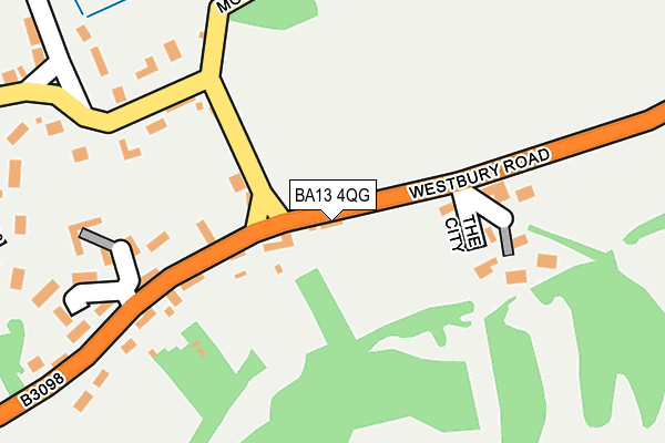
BA13 4QG lies on Westbury Road in Edington, Westbury. BA13 4QG is located in the Ethandune electoral ward, within the unitary authority of Wiltshire and the English Parliamentary constituency of South West Wiltshire. The Sub Integrated Care Board (ICB) Location is NHS Bath and North East Somerset, Swindon and Wiltshire ICB - 92 and the police force is Wiltshire. This postcode has been in use since January 1980.


GetTheData
Source: OS OpenMap – Local (Ordnance Survey)
Source: OS VectorMap District (Ordnance Survey)
Licence: Open Government Licence (requires attribution)
| Easting | 392738 |
| Northing | 153079 |
| Latitude | 51.276809 |
| Longitude | -2.105494 |
GetTheData
Source: Open Postcode Geo
Licence: Open Government Licence
| Street | Westbury Road |
| Locality | Edington |
| Town/City | Westbury |
| Country | England |
| Postcode District | BA13 |
➜ See where BA13 is on a map ➜ Where is Edington? | |
GetTheData
Source: Land Registry Price Paid Data
Licence: Open Government Licence
Elevation or altitude of BA13 4QG as distance above sea level:
| Metres | Feet | |
|---|---|---|
| Elevation | 100m | 328ft |
Elevation is measured from the approximate centre of the postcode, to the nearest point on an OS contour line from OS Terrain 50, which has contour spacing of ten vertical metres.
➜ How high above sea level am I? Find the elevation of your current position using your device's GPS.
GetTheData
Source: Open Postcode Elevation
Licence: Open Government Licence
| Ward | Ethandune |
| Constituency | South West Wiltshire |
GetTheData
Source: ONS Postcode Database
Licence: Open Government Licence
42, WESTBURY ROAD, EDINGTON, WESTBURY, BA13 4QG 1996 20 DEC £82,500 |
44, WESTBURY ROAD, EDINGTON, WESTBURY, BA13 4QG 1996 24 MAY £101,000 |
42, WESTBURY ROAD, EDINGTON, WESTBURY, BA13 4QG 1995 7 JUL £52,500 |
GetTheData
Source: HM Land Registry Price Paid Data
Licence: Contains HM Land Registry data © Crown copyright and database right 2025. This data is licensed under the Open Government Licence v3.0.
| Monastery Road (Westbury Road) | Edington | 52m |
| Monastery Road (Westbury Road) | Edington | 61m |
| Parish Church (Monastery Road) | Edington | 226m |
| Old Schoolhouse (Westbury Road) | Edington | 597m |
| Tinhead Road | Edington | 603m |
GetTheData
Source: NaPTAN
Licence: Open Government Licence
| Percentage of properties with Next Generation Access | 100.0% |
| Percentage of properties with Superfast Broadband | 100.0% |
| Percentage of properties with Ultrafast Broadband | 0.0% |
| Percentage of properties with Full Fibre Broadband | 0.0% |
Superfast Broadband is between 30Mbps and 300Mbps
Ultrafast Broadband is > 300Mbps
| Percentage of properties unable to receive 2Mbps | 0.0% |
| Percentage of properties unable to receive 5Mbps | 0.0% |
| Percentage of properties unable to receive 10Mbps | 0.0% |
| Percentage of properties unable to receive 30Mbps | 0.0% |
GetTheData
Source: Ofcom
Licence: Ofcom Terms of Use (requires attribution)
GetTheData
Source: ONS Postcode Database
Licence: Open Government Licence

➜ Get more ratings from the Food Standards Agency
GetTheData
Source: Food Standards Agency
Licence: FSA terms & conditions
| Last Collection | |||
|---|---|---|---|
| Location | Mon-Fri | Sat | Distance |
| Bratton Post Office | 16:30 | 11:00 | 1,368m |
| High Street | 16:30 | 10:00 | 4,392m |
| Erlestoke Park | 16:00 | 08:30 | 4,649m |
GetTheData
Source: Dracos
Licence: Creative Commons Attribution-ShareAlike
The below table lists the International Territorial Level (ITL) codes (formerly Nomenclature of Territorial Units for Statistics (NUTS) codes) and Local Administrative Units (LAU) codes for BA13 4QG:
| ITL 1 Code | Name |
|---|---|
| TLK | South West (England) |
| ITL 2 Code | Name |
| TLK1 | Gloucestershire, Wiltshire and Bath/Bristol area |
| ITL 3 Code | Name |
| TLK15 | Wiltshire |
| LAU 1 Code | Name |
| E06000054 | Wiltshire |
GetTheData
Source: ONS Postcode Directory
Licence: Open Government Licence
The below table lists the Census Output Area (OA), Lower Layer Super Output Area (LSOA), and Middle Layer Super Output Area (MSOA) for BA13 4QG:
| Code | Name | |
|---|---|---|
| OA | E00163505 | |
| LSOA | E01032055 | Wiltshire 039C |
| MSOA | E02006690 | Wiltshire 039 |
GetTheData
Source: ONS Postcode Directory
Licence: Open Government Licence
| BA13 4QQ | The City | 143m |
| BA13 4QH | Monastery Road | 148m |
| BA13 4QF | Westbury Road | 165m |
| BA13 4QN | Lower Road | 185m |
| BA13 4QS | Parsonage Lane | 233m |
| BA13 4QL | Downsview | 260m |
| BA13 4QE | Westbury Road | 275m |
| BA13 4QA | Greatwoods | 338m |
| BA13 4QJ | Monastery Road | 341m |
| BA13 4QW | Lower Road | 343m |
GetTheData
Source: Open Postcode Geo; Land Registry Price Paid Data
Licence: Open Government Licence