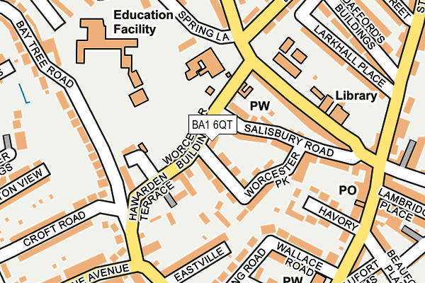
BA1 6QT lies on Worcester Court in Bath. BA1 6QT is located in the Lambridge electoral ward, within the unitary authority of Bath and North East Somerset and the English Parliamentary constituency of Bath. The Sub Integrated Care Board (ICB) Location is NHS Bath and North East Somerset, Swindon and Wiltshire ICB - 92 and the police force is Avon and Somerset. This postcode has been in use since January 1980.


GetTheData
Source: OS OpenMap – Local (Ordnance Survey)
Source: OS VectorMap District (Ordnance Survey)
Licence: Open Government Licence (requires attribution)
| Easting | 375851 |
| Northing | 166558 |
| Latitude | 51.397537 |
| Longitude | -2.348505 |
GetTheData
Source: Open Postcode Geo
Licence: Open Government Licence
| Street | Worcester Court |
| Town/City | Bath |
| Country | England |
| Postcode District | BA1 |
➜ See where BA1 is on a map ➜ Where is Bath? | |
GetTheData
Source: Land Registry Price Paid Data
Licence: Open Government Licence
Elevation or altitude of BA1 6QT as distance above sea level:
| Metres | Feet | |
|---|---|---|
| Elevation | 40m | 131ft |
Elevation is measured from the approximate centre of the postcode, to the nearest point on an OS contour line from OS Terrain 50, which has contour spacing of ten vertical metres.
➜ How high above sea level am I? Find the elevation of your current position using your device's GPS.
GetTheData
Source: Open Postcode Elevation
Licence: Open Government Licence
| Ward | Lambridge |
| Constituency | Bath |
GetTheData
Source: ONS Postcode Database
Licence: Open Government Licence
| Croft Road (Bay Tree Road) | Fairfield Park | 142m |
| Eldon Place (Charlcombe Lane) | Larkhall | 165m |
| St Marks School (Spring Lane) | Larkhall | 179m |
| St Marks School (Spring Lane) | Larkhall | 193m |
| Larkhall Square | Larkhall | 216m |
| Bath Spa Station | 2.3km |
| Oldfield Park Station | 3km |
GetTheData
Source: NaPTAN
Licence: Open Government Licence
| Percentage of properties with Next Generation Access | 100.0% |
| Percentage of properties with Superfast Broadband | 100.0% |
| Percentage of properties with Ultrafast Broadband | 0.0% |
| Percentage of properties with Full Fibre Broadband | 0.0% |
Superfast Broadband is between 30Mbps and 300Mbps
Ultrafast Broadband is > 300Mbps
| Percentage of properties unable to receive 2Mbps | 0.0% |
| Percentage of properties unable to receive 5Mbps | 0.0% |
| Percentage of properties unable to receive 10Mbps | 0.0% |
| Percentage of properties unable to receive 30Mbps | 0.0% |
GetTheData
Source: Ofcom
Licence: Ofcom Terms of Use (requires attribution)
GetTheData
Source: ONS Postcode Database
Licence: Open Government Licence


➜ Get more ratings from the Food Standards Agency
GetTheData
Source: Food Standards Agency
Licence: FSA terms & conditions
| Last Collection | |||
|---|---|---|---|
| Location | Mon-Fri | Sat | Distance |
| Claremont Road | 17:15 | 12:00 | 230m |
| Larkhall P.o. | 17:30 | 12:00 | 235m |
| Eldon Place | 17:30 | 11:30 | 306m |
GetTheData
Source: Dracos
Licence: Creative Commons Attribution-ShareAlike
The below table lists the International Territorial Level (ITL) codes (formerly Nomenclature of Territorial Units for Statistics (NUTS) codes) and Local Administrative Units (LAU) codes for BA1 6QT:
| ITL 1 Code | Name |
|---|---|
| TLK | South West (England) |
| ITL 2 Code | Name |
| TLK1 | Gloucestershire, Wiltshire and Bath/Bristol area |
| ITL 3 Code | Name |
| TLK12 | Bath and North East Somerset, North Somerset and South Gloucestershire |
| LAU 1 Code | Name |
| E06000022 | Bath and North East Somerset |
GetTheData
Source: ONS Postcode Directory
Licence: Open Government Licence
The below table lists the Census Output Area (OA), Lower Layer Super Output Area (LSOA), and Middle Layer Super Output Area (MSOA) for BA1 6QT:
| Code | Name | |
|---|---|---|
| OA | E00072788 | |
| LSOA | E01014410 | Bath and North East Somerset 004B |
| MSOA | E02002988 | Bath and North East Somerset 004 |
GetTheData
Source: ONS Postcode Directory
Licence: Open Government Licence
| BA1 6QZ | Salisbury Road | 60m |
| BA1 6QU | Worcester Park | 69m |
| BA1 6QS | Worcester Buildings | 70m |
| BA1 6FE | St Mark's Place | 86m |
| BA1 6RD | Avondale Buildings | 112m |
| BA1 6QR | Worcester Villas | 122m |
| BA1 6RE | Hawarden Terrace | 126m |
| BA1 6QX | Salisbury Road | 130m |
| BA1 6QP | Worcester Place | 133m |
| BA1 6RA | Brookleaze Buildings | 145m |
GetTheData
Source: Open Postcode Geo; Land Registry Price Paid Data
Licence: Open Government Licence