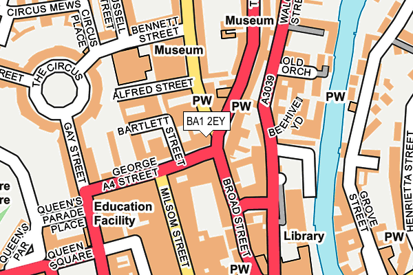
BA1 2EY is located in the Kingsmead electoral ward, within the unitary authority of Bath and North East Somerset and the English Parliamentary constituency of Bath. The Sub Integrated Care Board (ICB) Location is NHS Bath and North East Somerset, Swindon and Wiltshire ICB - 92 and the police force is Avon and Somerset. This postcode has been in use since January 1980.


GetTheData
Source: OS OpenMap – Local (Ordnance Survey)
Source: OS VectorMap District (Ordnance Survey)
Licence: Open Government Licence (requires attribution)
| Easting | 374978 |
| Northing | 165204 |
| Latitude | 51.385324 |
| Longitude | -2.360958 |
GetTheData
Source: Open Postcode Geo
Licence: Open Government Licence
| Country | England |
| Postcode District | BA1 |
➜ See where BA1 is on a map ➜ Where is Bath? | |
GetTheData
Source: Land Registry Price Paid Data
Licence: Open Government Licence
Elevation or altitude of BA1 2EY as distance above sea level:
| Metres | Feet | |
|---|---|---|
| Elevation | 40m | 131ft |
Elevation is measured from the approximate centre of the postcode, to the nearest point on an OS contour line from OS Terrain 50, which has contour spacing of ten vertical metres.
➜ How high above sea level am I? Find the elevation of your current position using your device's GPS.
GetTheData
Source: Open Postcode Elevation
Licence: Open Government Licence
| Ward | Kingsmead |
| Constituency | Bath |
GetTheData
Source: ONS Postcode Database
Licence: Open Government Licence
| Alfred Street (Lansdown Road) | Bath City Centre | 63m |
| Hilton Hotel (Walcot Street) | Bath City Centre | 87m |
| Hilton Hotel (Walcot Street) | Bath City Centre | 113m |
| Alfred Street (Lansdown Road) | Bath City Centre | 113m |
| Milsom Street | Bath City Centre | 141m |
| Bath Spa Station | 0.9km |
| Oldfield Park Station | 1.5km |
| Freshford Station | 6.4km |
GetTheData
Source: NaPTAN
Licence: Open Government Licence
GetTheData
Source: ONS Postcode Database
Licence: Open Government Licence


➜ Get more ratings from the Food Standards Agency
GetTheData
Source: Food Standards Agency
Licence: FSA terms & conditions
| Last Collection | |||
|---|---|---|---|
| Location | Mon-Fri | Sat | Distance |
| Milsom Street | 17:30 | 12:45 | 90m |
| Paragon | 17:30 | 12:30 | 91m |
| Walcot Street | 17:30 | 12:30 | 106m |
GetTheData
Source: Dracos
Licence: Creative Commons Attribution-ShareAlike
The below table lists the International Territorial Level (ITL) codes (formerly Nomenclature of Territorial Units for Statistics (NUTS) codes) and Local Administrative Units (LAU) codes for BA1 2EY:
| ITL 1 Code | Name |
|---|---|
| TLK | South West (England) |
| ITL 2 Code | Name |
| TLK1 | Gloucestershire, Wiltshire and Bath/Bristol area |
| ITL 3 Code | Name |
| TLK12 | Bath and North East Somerset, North Somerset and South Gloucestershire |
| LAU 1 Code | Name |
| E06000022 | Bath and North East Somerset |
GetTheData
Source: ONS Postcode Directory
Licence: Open Government Licence
The below table lists the Census Output Area (OA), Lower Layer Super Output Area (LSOA), and Middle Layer Super Output Area (MSOA) for BA1 2EY:
| Code | Name | |
|---|---|---|
| OA | E00072566 | |
| LSOA | E01014372 | Bath and North East Somerset 007C |
| MSOA | E02002991 | Bath and North East Somerset 007 |
GetTheData
Source: ONS Postcode Directory
Licence: Open Government Licence
| BA1 2ED | Princes Buildings | 25m |
| BA1 5DX | Fountain Buildings | 30m |
| BA1 5DY | Lansdown Mews | 42m |
| BA1 5LS | Bladud Buildings | 47m |
| BA1 5DU | Fountain Buildings | 48m |
| BA1 5LN | Broad Street | 56m |
| BA1 2QZ | Bartlett Street | 61m |
| BA1 2EE | Edgar Buildings | 78m |
| BA1 2QU | Alfred Street | 78m |
| BA1 5LZ | Hay Hill | 84m |
GetTheData
Source: Open Postcode Geo; Land Registry Price Paid Data
Licence: Open Government Licence