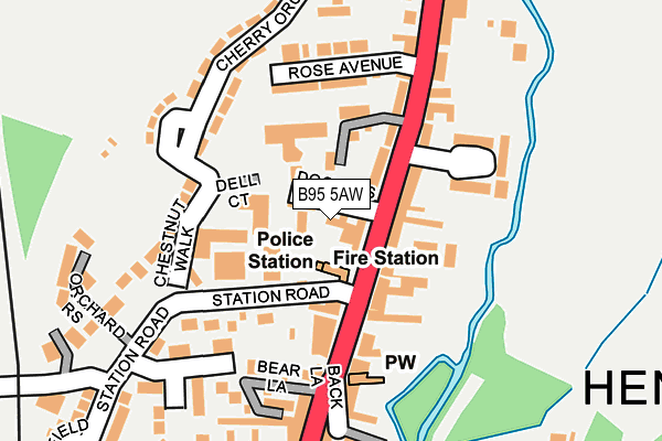
B95 5AW lies on Doctors Lane in Henley-in-arden. B95 5AW is located in the Henley-in-Arden electoral ward, within the local authority district of Stratford-on-Avon and the English Parliamentary constituency of Stratford-on-Avon. The Sub Integrated Care Board (ICB) Location is NHS Coventry and Warwickshire ICB - B2M3M and the police force is Warwickshire. This postcode has been in use since January 1993.


GetTheData
Source: OS OpenMap – Local (Ordnance Survey)
Source: OS VectorMap District (Ordnance Survey)
Licence: Open Government Licence (requires attribution)
| Easting | 415117 |
| Northing | 266275 |
| Latitude | 52.294400 |
| Longitude | -1.779769 |
GetTheData
Source: Open Postcode Geo
Licence: Open Government Licence
| Street | Doctors Lane |
| Town/City | Henley-in-arden |
| Country | England |
| Postcode District | B95 |
➜ See where B95 is on a map ➜ Where is Henley-in-Arden? | |
GetTheData
Source: Land Registry Price Paid Data
Licence: Open Government Licence
Elevation or altitude of B95 5AW as distance above sea level:
| Metres | Feet | |
|---|---|---|
| Elevation | 80m | 262ft |
Elevation is measured from the approximate centre of the postcode, to the nearest point on an OS contour line from OS Terrain 50, which has contour spacing of ten vertical metres.
➜ How high above sea level am I? Find the elevation of your current position using your device's GPS.
GetTheData
Source: Open Postcode Elevation
Licence: Open Government Licence
| Ward | Henley-in-arden |
| Constituency | Stratford-on-avon |
GetTheData
Source: ONS Postcode Database
Licence: Open Government Licence
| Three Tuns (High Street) | Henley-in-arden | 79m |
| Three Tuns (High Street) | Henley-in-arden | 88m |
| Tudor Dairies (High Street) | Henley-in-arden | 500m |
| Arden Road (Castle Road) | Henley-in-arden | 603m |
| Yew Tree Gardens (Brook End Drive) | Henley-in-arden | 625m |
| Henley-in-Arden Station | 0.4km |
| Wootton Wawen Station | 3.1km |
| Danzey Station | 4.4km |
GetTheData
Source: NaPTAN
Licence: Open Government Licence
| Percentage of properties with Next Generation Access | 100.0% |
| Percentage of properties with Superfast Broadband | 100.0% |
| Percentage of properties with Ultrafast Broadband | 0.0% |
| Percentage of properties with Full Fibre Broadband | 0.0% |
Superfast Broadband is between 30Mbps and 300Mbps
Ultrafast Broadband is > 300Mbps
| Percentage of properties unable to receive 2Mbps | 0.0% |
| Percentage of properties unable to receive 5Mbps | 0.0% |
| Percentage of properties unable to receive 10Mbps | 0.0% |
| Percentage of properties unable to receive 30Mbps | 0.0% |
GetTheData
Source: Ofcom
Licence: Ofcom Terms of Use (requires attribution)
GetTheData
Source: ONS Postcode Database
Licence: Open Government Licence


➜ Get more ratings from the Food Standards Agency
GetTheData
Source: Food Standards Agency
Licence: FSA terms & conditions
| Last Collection | |||
|---|---|---|---|
| Location | Mon-Fri | Sat | Distance |
| Henley In Arden Post Office | 17:30 | 11:00 | 257m |
| Hunger Hill | 09:00 | 08:30 | 1,343m |
| Beaudesert | 10:00 | 07:40 | 1,643m |
GetTheData
Source: Dracos
Licence: Creative Commons Attribution-ShareAlike
The below table lists the International Territorial Level (ITL) codes (formerly Nomenclature of Territorial Units for Statistics (NUTS) codes) and Local Administrative Units (LAU) codes for B95 5AW:
| ITL 1 Code | Name |
|---|---|
| TLG | West Midlands (England) |
| ITL 2 Code | Name |
| TLG1 | Herefordshire, Worcestershire and Warwickshire |
| ITL 3 Code | Name |
| TLG13 | Warwickshire CC |
| LAU 1 Code | Name |
| E07000221 | Stratford-on-Avon |
GetTheData
Source: ONS Postcode Directory
Licence: Open Government Licence
The below table lists the Census Output Area (OA), Lower Layer Super Output Area (LSOA), and Middle Layer Super Output Area (MSOA) for B95 5AW:
| Code | Name | |
|---|---|---|
| OA | E00159072 | |
| LSOA | E01031202 | Stratford-on-Avon 002B |
| MSOA | E02006505 | Stratford-on-Avon 002 |
GetTheData
Source: ONS Postcode Directory
Licence: Open Government Licence
| B95 5AT | High Street | 60m |
| B95 5AN | High Street | 65m |
| B95 5GN | Chestnut Walk | 69m |
| B95 5FN | The Coach Houses | 79m |
| B95 5AJ | The Tanyard | 95m |
| B95 5BX | High Street | 111m |
| B95 5GP | Chestnut Walk | 118m |
| B95 5JR | Rose Avenue | 126m |
| B95 5JP | Station Road | 132m |
| B95 5JN | Chestnut Walk | 139m |
GetTheData
Source: Open Postcode Geo; Land Registry Price Paid Data
Licence: Open Government Licence