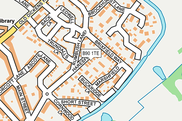
B90 1TE lies on Haresfield in Shirley, Solihull. B90 1TE is located in the Blythe electoral ward, within the metropolitan district of Solihull and the English Parliamentary constituency of Meriden. The Sub Integrated Care Board (ICB) Location is NHS Birmingham and Solihull ICB - 15E and the police force is West Midlands. This postcode has been in use since June 2002.


GetTheData
Source: OS OpenMap – Local (Ordnance Survey)
Source: OS VectorMap District (Ordnance Survey)
Licence: Open Government Licence (requires attribution)
| Easting | 411478 |
| Northing | 276342 |
| Latitude | 52.384991 |
| Longitude | -1.832785 |
GetTheData
Source: Open Postcode Geo
Licence: Open Government Licence
| Street | Haresfield |
| Locality | Shirley |
| Town/City | Solihull |
| Country | England |
| Postcode District | B90 |
➜ See where B90 is on a map ➜ Where is Dickens Heath? | |
GetTheData
Source: Land Registry Price Paid Data
Licence: Open Government Licence
Elevation or altitude of B90 1TE as distance above sea level:
| Metres | Feet | |
|---|---|---|
| Elevation | 140m | 459ft |
Elevation is measured from the approximate centre of the postcode, to the nearest point on an OS contour line from OS Terrain 50, which has contour spacing of ten vertical metres.
➜ How high above sea level am I? Find the elevation of your current position using your device's GPS.
GetTheData
Source: Open Postcode Elevation
Licence: Open Government Licence
| Ward | Blythe |
| Constituency | Meriden |
GetTheData
Source: ONS Postcode Database
Licence: Open Government Licence
| Tythe Barn Lane (Dickens Heath Rd) | Dickens Heath | 277m |
| Tythe Barn Lane (Dickens Heath Rd) | Dickens Heath | 321m |
| Calcutt Way (Dickens Heath Rd) | Dickens Heath | 410m |
| Boundary Lane (Dickens Heath Rd) | Dickens Heath | 416m |
| Meadow Pleck Lane (Dickens Heath Rd) | Dickens Heath | 445m |
| Whitlocks End Station | 1.5km |
| Shirley Station | 2.2km |
| Wythall Station | 2.3km |
GetTheData
Source: NaPTAN
Licence: Open Government Licence
| Percentage of properties with Next Generation Access | 100.0% |
| Percentage of properties with Superfast Broadband | 100.0% |
| Percentage of properties with Ultrafast Broadband | 0.0% |
| Percentage of properties with Full Fibre Broadband | 0.0% |
Superfast Broadband is between 30Mbps and 300Mbps
Ultrafast Broadband is > 300Mbps
| Median download speed | 78.1Mbps |
| Average download speed | 67.3Mbps |
| Maximum download speed | 80.00Mbps |
| Median upload speed | 20.0Mbps |
| Average upload speed | 17.0Mbps |
| Maximum upload speed | 20.00Mbps |
| Percentage of properties unable to receive 2Mbps | 0.0% |
| Percentage of properties unable to receive 5Mbps | 0.0% |
| Percentage of properties unable to receive 10Mbps | 0.0% |
| Percentage of properties unable to receive 30Mbps | 0.0% |
GetTheData
Source: Ofcom
Licence: Ofcom Terms of Use (requires attribution)
Estimated total energy consumption in B90 1TE by fuel type, 2015.
| Consumption (kWh) | 101,201 |
|---|---|
| Meter count | 6 |
| Mean (kWh/meter) | 16,867 |
| Median (kWh/meter) | 18,269 |
GetTheData
Source: Postcode level gas estimates: 2015 (experimental)
Source: Postcode level electricity estimates: 2015 (experimental)
Licence: Open Government Licence
GetTheData
Source: ONS Postcode Database
Licence: Open Government Licence


➜ Get more ratings from the Food Standards Agency
GetTheData
Source: Food Standards Agency
Licence: FSA terms & conditions
| Last Collection | |||
|---|---|---|---|
| Location | Mon-Fri | Sat | Distance |
| Dickens Heath / Birchy Close | 17:15 | 11:30 | 365m |
| Cheswick Green Post Office | 18:30 | 11:30 | 1,410m |
| Stretton Road Post Office | 18:30 | 11:30 | 1,413m |
GetTheData
Source: Dracos
Licence: Creative Commons Attribution-ShareAlike
The below table lists the International Territorial Level (ITL) codes (formerly Nomenclature of Territorial Units for Statistics (NUTS) codes) and Local Administrative Units (LAU) codes for B90 1TE:
| ITL 1 Code | Name |
|---|---|
| TLG | West Midlands (England) |
| ITL 2 Code | Name |
| TLG3 | West Midlands |
| ITL 3 Code | Name |
| TLG32 | Solihull |
| LAU 1 Code | Name |
| E08000029 | Solihull |
GetTheData
Source: ONS Postcode Directory
Licence: Open Government Licence
The below table lists the Census Output Area (OA), Lower Layer Super Output Area (LSOA), and Middle Layer Super Output Area (MSOA) for B90 1TE:
| Code | Name | |
|---|---|---|
| OA | E00168173 | |
| LSOA | E01032886 | Solihull 029G |
| MSOA | E02002109 | Solihull 029 |
GetTheData
Source: ONS Postcode Directory
Licence: Open Government Licence
| B90 1TD | Marshfield | 57m |
| B90 1RQ | Brixfield Way | 76m |
| B90 1RA | Rumbush Lane | 86m |
| B90 1ST | Wadbarn | 103m |
| B90 1TF | Buckridge Lane | 111m |
| B90 1SS | Trundalls Lane | 131m |
| B90 1TG | Short Street | 136m |
| B90 1RG | Brockhurst Lane | 155m |
| B90 1TP | Ascote Lane | 161m |
| B90 1TJ | Rumbush Lane | 161m |
GetTheData
Source: Open Postcode Geo; Land Registry Price Paid Data
Licence: Open Government Licence