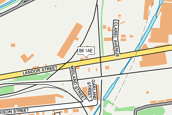
B8 1AE is located in the Nechells electoral ward, within the metropolitan district of Birmingham and the English Parliamentary constituency of Birmingham, Ladywood. The Sub Integrated Care Board (ICB) Location is NHS Birmingham and Solihull ICB - 15E and the police force is West Midlands. This postcode has been in use since January 1980.


GetTheData
Source: OS OpenMap – Local (Ordnance Survey)
Source: OS VectorMap District (Ordnance Survey)
Licence: Open Government Licence (requires attribution)
| Easting | 409017 |
| Northing | 287164 |
| Latitude | 52.482340 |
| Longitude | -1.868650 |
GetTheData
Source: Open Postcode Geo
Licence: Open Government Licence
| Country | England |
| Postcode District | B8 |
➜ See where B8 is on a map ➜ Where is Birmingham? | |
GetTheData
Source: Land Registry Price Paid Data
Licence: Open Government Licence
Elevation or altitude of B8 1AE as distance above sea level:
| Metres | Feet | |
|---|---|---|
| Elevation | 100m | 328ft |
Elevation is measured from the approximate centre of the postcode, to the nearest point on an OS contour line from OS Terrain 50, which has contour spacing of ten vertical metres.
➜ How high above sea level am I? Find the elevation of your current position using your device's GPS.
GetTheData
Source: Open Postcode Elevation
Licence: Open Government Licence
| Ward | Nechells |
| Constituency | Birmingham, Ladywood |
GetTheData
Source: ONS Postcode Database
Licence: Open Government Licence
| Witton St (Garrison Lane) | Bordesley | 370m |
| Witton St (Garrison Lane) | Bordesley | 370m |
| Maxstoke St (Garrison Lane) | Bordesley | 406m |
| Maxstoke St (Garrison Lane) | Bordesley | 421m |
| Venetia Rd (Garrison Lane) | Bordesley | 496m |
| Duddeston Station | 0.7km |
| Adderley Park Station | 0.9km |
| Bordesley Station | 1.3km |
GetTheData
Source: NaPTAN
Licence: Open Government Licence
| Percentage of properties with Next Generation Access | 0.0% |
| Percentage of properties with Superfast Broadband | 0.0% |
| Percentage of properties with Ultrafast Broadband | 0.0% |
| Percentage of properties with Full Fibre Broadband | 0.0% |
Superfast Broadband is between 30Mbps and 300Mbps
Ultrafast Broadband is > 300Mbps
| Percentage of properties unable to receive 2Mbps | 0.0% |
| Percentage of properties unable to receive 5Mbps | 0.0% |
| Percentage of properties unable to receive 10Mbps | 100.0% |
| Percentage of properties unable to receive 30Mbps | 100.0% |
GetTheData
Source: Ofcom
Licence: Ofcom Terms of Use (requires attribution)
GetTheData
Source: ONS Postcode Database
Licence: Open Government Licence

➜ Get more ratings from the Food Standards Agency
GetTheData
Source: Food Standards Agency
Licence: FSA terms & conditions
| Last Collection | |||
|---|---|---|---|
| Location | Mon-Fri | Sat | Distance |
| Grey Street | 18:30 | 11:30 | 382m |
| Duddeston Mill Road | 18:30 | 12:30 | 693m |
| Vauxhall Post Office | 18:30 | 12:30 | 724m |
GetTheData
Source: Dracos
Licence: Creative Commons Attribution-ShareAlike
The below table lists the International Territorial Level (ITL) codes (formerly Nomenclature of Territorial Units for Statistics (NUTS) codes) and Local Administrative Units (LAU) codes for B8 1AE:
| ITL 1 Code | Name |
|---|---|
| TLG | West Midlands (England) |
| ITL 2 Code | Name |
| TLG3 | West Midlands |
| ITL 3 Code | Name |
| TLG31 | Birmingham |
| LAU 1 Code | Name |
| E08000025 | Birmingham |
GetTheData
Source: ONS Postcode Directory
Licence: Open Government Licence
The below table lists the Census Output Area (OA), Lower Layer Super Output Area (LSOA), and Middle Layer Super Output Area (MSOA) for B8 1AE:
| Code | Name | |
|---|---|---|
| OA | E00046656 | |
| LSOA | E01009199 | Birmingham 052D |
| MSOA | E02001878 | Birmingham 052 |
GetTheData
Source: ONS Postcode Directory
Licence: Open Government Licence
| B9 4DH | Wolseley Street | 140m |
| B9 4PL | Isbourne Way | 162m |
| B9 4NW | Wolseley Street | 200m |
| B9 4PH | Mill Burn Way | 211m |
| B9 4PW | Mease Croft | 216m |
| B9 4PQ | Keer Court | 266m |
| B9 4QH | Artillery Street | 273m |
| B9 4PJ | Alport Croft | 298m |
| B9 4BN | Garrison Street | 304m |
| B9 4PG | Hoff Beck Court | 329m |
GetTheData
Source: Open Postcode Geo; Land Registry Price Paid Data
Licence: Open Government Licence