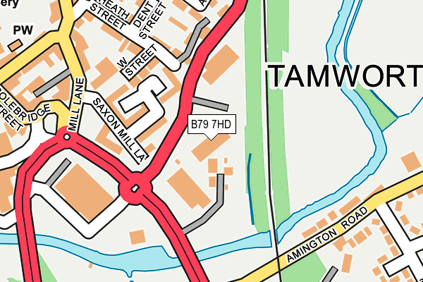
B79 7HD is located in the Castle electoral ward, within the local authority district of Tamworth and the English Parliamentary constituency of Tamworth. The Sub Integrated Care Board (ICB) Location is NHS Staffordshire and Stoke-on-Trent ICB - 05Q and the police force is Staffordshire. This postcode has been in use since December 1999.


GetTheData
Source: OS OpenMap – Local (Ordnance Survey)
Source: OS VectorMap District (Ordnance Survey)
Licence: Open Government Licence (requires attribution)
| Easting | 421226 |
| Northing | 303927 |
| Latitude | 52.632685 |
| Longitude | -1.687814 |
GetTheData
Source: Open Postcode Geo
Licence: Open Government Licence
| Country | England |
| Postcode District | B79 |
➜ See where B79 is on a map ➜ Where is Tamworth? | |
GetTheData
Source: Land Registry Price Paid Data
Licence: Open Government Licence
Elevation or altitude of B79 7HD as distance above sea level:
| Metres | Feet | |
|---|---|---|
| Elevation | 60m | 197ft |
Elevation is measured from the approximate centre of the postcode, to the nearest point on an OS contour line from OS Terrain 50, which has contour spacing of ten vertical metres.
➜ How high above sea level am I? Find the elevation of your current position using your device's GPS.
GetTheData
Source: Open Postcode Elevation
Licence: Open Government Licence
| Ward | Castle |
| Constituency | Tamworth |
GetTheData
Source: ONS Postcode Database
Licence: Open Government Licence
| Aldi Store (Saxon Dr) | Tamworth Town Centre | 122m |
| Aldi Store (Saxon Dr) | Tamworth Town Centre | 139m |
| Manor Road (Amington Rd) | Bolehall | 195m |
| Railway Viaduct (Amington Rd) | Bolehall | 204m |
| Kettlebrook Road (Glascote Rd) | Bolehall | 264m |
| Tamworth Station | 0.5km |
| Tamworth High Level Station | 0.5km |
| Wilnecote (Staffs) Station | 2.5km |
GetTheData
Source: NaPTAN
Licence: Open Government Licence
GetTheData
Source: ONS Postcode Database
Licence: Open Government Licence


➜ Get more ratings from the Food Standards Agency
GetTheData
Source: Food Standards Agency
Licence: FSA terms & conditions
| Last Collection | |||
|---|---|---|---|
| Location | Mon-Fri | Sat | Distance |
| Tamworth P.o. | 18:45 | 12:30 | 445m |
| Tweedale | 18:30 | 11:30 | 463m |
| 2 Albert Road | 18:30 | 11:30 | 584m |
GetTheData
Source: Dracos
Licence: Creative Commons Attribution-ShareAlike
The below table lists the International Territorial Level (ITL) codes (formerly Nomenclature of Territorial Units for Statistics (NUTS) codes) and Local Administrative Units (LAU) codes for B79 7HD:
| ITL 1 Code | Name |
|---|---|
| TLG | West Midlands (England) |
| ITL 2 Code | Name |
| TLG2 | Shropshire and Staffordshire |
| ITL 3 Code | Name |
| TLG24 | Staffordshire CC |
| LAU 1 Code | Name |
| E07000199 | Tamworth |
GetTheData
Source: ONS Postcode Directory
Licence: Open Government Licence
The below table lists the Census Output Area (OA), Lower Layer Super Output Area (LSOA), and Middle Layer Super Output Area (MSOA) for B79 7HD:
| Code | Name | |
|---|---|---|
| OA | E00152048 | |
| LSOA | E01029838 | Tamworth 005C |
| MSOA | E02006221 | Tamworth 005 |
GetTheData
Source: ONS Postcode Directory
Licence: Open Government Licence
| B79 7JJ | Saxon Mill Lane | 77m |
| B79 7JD | Saxon Mill Lane | 138m |
| B79 7JF | West Street | 140m |
| B79 7HF | Hardwick Court | 159m |
| B79 7JE | West Street | 179m |
| B79 7JH | Heath Street | 183m |
| B79 7JL | Dent Street | 199m |
| B77 3BF | Amington Road | 201m |
| B79 7JA | Mill Lane | 223m |
| B79 7HT | Alexandra Mews | 230m |
GetTheData
Source: Open Postcode Geo; Land Registry Price Paid Data
Licence: Open Government Licence