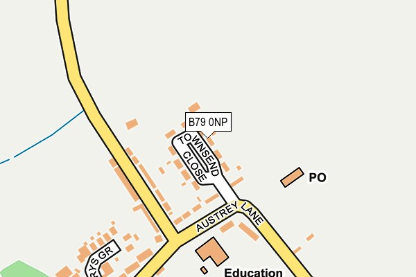
B79 0NP lies on Townsend Close in Newton Regis, Tamworth. B79 0NP is located in the Newton Regis and Warton electoral ward, within the local authority district of North Warwickshire and the English Parliamentary constituency of North Warwickshire. The Sub Integrated Care Board (ICB) Location is NHS Coventry and Warwickshire ICB - B2M3M and the police force is Warwickshire. This postcode has been in use since January 1980.


GetTheData
Source: OS OpenMap – Local (Ordnance Survey)
Source: OS VectorMap District (Ordnance Survey)
Licence: Open Government Licence (requires attribution)
| Easting | 427998 |
| Northing | 307703 |
| Latitude | 52.666323 |
| Longitude | -1.587438 |
GetTheData
Source: Open Postcode Geo
Licence: Open Government Licence
| Street | Townsend Close |
| Locality | Newton Regis |
| Town/City | Tamworth |
| Country | England |
| Postcode District | B79 |
➜ See where B79 is on a map ➜ Where is Newton Regis? | |
GetTheData
Source: Land Registry Price Paid Data
Licence: Open Government Licence
Elevation or altitude of B79 0NP as distance above sea level:
| Metres | Feet | |
|---|---|---|
| Elevation | 80m | 262ft |
Elevation is measured from the approximate centre of the postcode, to the nearest point on an OS contour line from OS Terrain 50, which has contour spacing of ten vertical metres.
➜ How high above sea level am I? Find the elevation of your current position using your device's GPS.
GetTheData
Source: Open Postcode Elevation
Licence: Open Government Licence
| Ward | Newton Regis And Warton |
| Constituency | North Warwickshire |
GetTheData
Source: ONS Postcode Database
Licence: Open Government Licence
| Townsend Close (Austrey Lane) | Newton Regis | 105m |
| Post Office (Austrey Lane) | Newton Regis | 405m |
| Hames Lane (Austrey Lane) | Newton Regis | 461m |
| Turn (Ashby Road) | Newton Regis | 797m |
| Ash Lane (Ashby Road) | No Mans Heath | 1,566m |
| Polesworth Station | 4.8km |
GetTheData
Source: NaPTAN
Licence: Open Government Licence
| Percentage of properties with Next Generation Access | 100.0% |
| Percentage of properties with Superfast Broadband | 100.0% |
| Percentage of properties with Ultrafast Broadband | 19.0% |
| Percentage of properties with Full Fibre Broadband | 0.0% |
Superfast Broadband is between 30Mbps and 300Mbps
Ultrafast Broadband is > 300Mbps
| Median download speed | 55.3Mbps |
| Average download speed | 51.3Mbps |
| Maximum download speed | 80.00Mbps |
| Median upload speed | 10.5Mbps |
| Average upload speed | 12.0Mbps |
| Maximum upload speed | 20.00Mbps |
| Percentage of properties unable to receive 2Mbps | 0.0% |
| Percentage of properties unable to receive 5Mbps | 0.0% |
| Percentage of properties unable to receive 10Mbps | 0.0% |
| Percentage of properties unable to receive 30Mbps | 0.0% |
GetTheData
Source: Ofcom
Licence: Ofcom Terms of Use (requires attribution)
Estimated total energy consumption in B79 0NP by fuel type, 2015.
| Consumption (kWh) | 262,631 |
|---|---|
| Meter count | 20 |
| Mean (kWh/meter) | 13,132 |
| Median (kWh/meter) | 13,139 |
| Consumption (kWh) | 60,790 |
|---|---|
| Meter count | 16 |
| Mean (kWh/meter) | 3,799 |
| Median (kWh/meter) | 3,434 |
GetTheData
Source: Postcode level gas estimates: 2015 (experimental)
Source: Postcode level electricity estimates: 2015 (experimental)
Licence: Open Government Licence
GetTheData
Source: ONS Postcode Database
Licence: Open Government Licence


➜ Get more ratings from the Food Standards Agency
GetTheData
Source: Food Standards Agency
Licence: FSA terms & conditions
| Last Collection | |||
|---|---|---|---|
| Location | Mon-Fri | Sat | Distance |
| Chilcote | 16:00 | 09:30 | 3,768m |
| Warton Post Office | 16:45 | 07:30 | 3,999m |
| Opp 1 Little Warton Road | 16:45 | 07:00 | 4,022m |
GetTheData
Source: Dracos
Licence: Creative Commons Attribution-ShareAlike
The below table lists the International Territorial Level (ITL) codes (formerly Nomenclature of Territorial Units for Statistics (NUTS) codes) and Local Administrative Units (LAU) codes for B79 0NP:
| ITL 1 Code | Name |
|---|---|
| TLG | West Midlands (England) |
| ITL 2 Code | Name |
| TLG1 | Herefordshire, Worcestershire and Warwickshire |
| ITL 3 Code | Name |
| TLG13 | Warwickshire CC |
| LAU 1 Code | Name |
| E07000218 | North Warwickshire |
GetTheData
Source: ONS Postcode Directory
Licence: Open Government Licence
The below table lists the Census Output Area (OA), Lower Layer Super Output Area (LSOA), and Middle Layer Super Output Area (MSOA) for B79 0NP:
| Code | Name | |
|---|---|---|
| OA | E00158219 | |
| LSOA | E01031036 | North Warwickshire 001B |
| MSOA | E02006468 | North Warwickshire 001 |
GetTheData
Source: ONS Postcode Directory
Licence: Open Government Licence
| B79 0NL | Austrey Lane | 128m |
| B79 0NN | Kings Lane | 134m |
| B79 0NG | Main Road | 223m |
| B79 0NJ | St Marys Grove | 247m |
| B79 0NA | Main Road | 335m |
| B79 0NF | Main Road | 384m |
| B79 0NH | Hames Lane | 461m |
| B79 0NE | Main Road | 467m |
| B79 0ND | Seckington Lane | 602m |
| B79 0NW | Kings Lane | 633m |
GetTheData
Source: Open Postcode Geo; Land Registry Price Paid Data
Licence: Open Government Licence