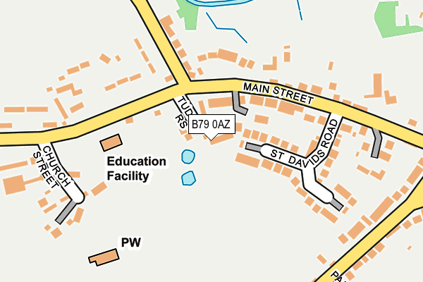
B79 0AZ lies on Tudor Rise in Clifton Campville, Tamworth. B79 0AZ is located in the Mease Valley electoral ward, within the local authority district of Lichfield and the English Parliamentary constituency of Tamworth. The Sub Integrated Care Board (ICB) Location is NHS Staffordshire and Stoke-on-Trent ICB - 05Q and the police force is Staffordshire. This postcode has been in use since January 1992.


GetTheData
Source: OS OpenMap – Local (Ordnance Survey)
Source: OS VectorMap District (Ordnance Survey)
Licence: Open Government Licence (requires attribution)
| Easting | 425444 |
| Northing | 310948 |
| Latitude | 52.695619 |
| Longitude | -1.624953 |
GetTheData
Source: Open Postcode Geo
Licence: Open Government Licence
| Street | Tudor Rise |
| Locality | Clifton Campville |
| Town/City | Tamworth |
| Country | England |
| Postcode District | B79 |
➜ See where B79 is on a map ➜ Where is Clifton Campville? | |
GetTheData
Source: Land Registry Price Paid Data
Licence: Open Government Licence
Elevation or altitude of B79 0AZ as distance above sea level:
| Metres | Feet | |
|---|---|---|
| Elevation | 70m | 230ft |
Elevation is measured from the approximate centre of the postcode, to the nearest point on an OS contour line from OS Terrain 50, which has contour spacing of ten vertical metres.
➜ How high above sea level am I? Find the elevation of your current position using your device's GPS.
GetTheData
Source: Open Postcode Elevation
Licence: Open Government Licence
| Ward | Mease Valley |
| Constituency | Tamworth |
GetTheData
Source: ONS Postcode Database
Licence: Open Government Licence
2023 21 APR £520,000 |
20, TUDOR RISE, CLIFTON CAMPVILLE, TAMWORTH, B79 0AZ 2022 28 NOV £377,500 |
14, TUDOR RISE, CLIFTON CAMPVILLE, TAMWORTH, B79 0AZ 2022 26 AUG £375,000 |
2020 2 SEP £425,000 |
2012 8 JUN £245,000 |
2002 14 OCT £238,000 |
1999 13 AUG £143,000 |
➜ Clifton Campville house prices
GetTheData
Source: HM Land Registry Price Paid Data
Licence: Contains HM Land Registry data © Crown copyright and database right 2025. This data is licensed under the Open Government Licence v3.0.
| Church Street (Main Street) | Clifton Campville | 188m |
| Church Street (Main Street) | Clifton Campville | 217m |
| Green Man Ph (Main Street) | Clifton Campville | 240m |
| Green Man Ph (Main Street) | Clifton Campville | 261m |
GetTheData
Source: NaPTAN
Licence: Open Government Licence
| Percentage of properties with Next Generation Access | 100.0% |
| Percentage of properties with Superfast Broadband | 100.0% |
| Percentage of properties with Ultrafast Broadband | 0.0% |
| Percentage of properties with Full Fibre Broadband | 0.0% |
Superfast Broadband is between 30Mbps and 300Mbps
Ultrafast Broadband is > 300Mbps
| Median download speed | 80.0Mbps |
| Average download speed | 59.1Mbps |
| Maximum download speed | 80.00Mbps |
| Median upload speed | 20.0Mbps |
| Average upload speed | 13.7Mbps |
| Maximum upload speed | 20.00Mbps |
| Percentage of properties unable to receive 2Mbps | 0.0% |
| Percentage of properties unable to receive 5Mbps | 0.0% |
| Percentage of properties unable to receive 10Mbps | 0.0% |
| Percentage of properties unable to receive 30Mbps | 0.0% |
GetTheData
Source: Ofcom
Licence: Ofcom Terms of Use (requires attribution)
Estimated total energy consumption in B79 0AZ by fuel type, 2015.
| Consumption (kWh) | 20,864 |
|---|---|
| Meter count | 6 |
| Mean (kWh/meter) | 3,477 |
| Median (kWh/meter) | 3,903 |
GetTheData
Source: Postcode level gas estimates: 2015 (experimental)
Source: Postcode level electricity estimates: 2015 (experimental)
Licence: Open Government Licence
GetTheData
Source: ONS Postcode Database
Licence: Open Government Licence


➜ Get more ratings from the Food Standards Agency
GetTheData
Source: Food Standards Agency
Licence: FSA terms & conditions
| Last Collection | |||
|---|---|---|---|
| Location | Mon-Fri | Sat | Distance |
| Lullington | 16:00 | 11:30 | 2,108m |
| Chilcote | 16:00 | 09:30 | 3,061m |
| Netherseal | 16:00 | 09:00 | 3,123m |
GetTheData
Source: Dracos
Licence: Creative Commons Attribution-ShareAlike
The below table lists the International Territorial Level (ITL) codes (formerly Nomenclature of Territorial Units for Statistics (NUTS) codes) and Local Administrative Units (LAU) codes for B79 0AZ:
| ITL 1 Code | Name |
|---|---|
| TLG | West Midlands (England) |
| ITL 2 Code | Name |
| TLG2 | Shropshire and Staffordshire |
| ITL 3 Code | Name |
| TLG24 | Staffordshire CC |
| LAU 1 Code | Name |
| E07000194 | Lichfield |
GetTheData
Source: ONS Postcode Directory
Licence: Open Government Licence
The below table lists the Census Output Area (OA), Lower Layer Super Output Area (LSOA), and Middle Layer Super Output Area (MSOA) for B79 0AZ:
| Code | Name | |
|---|---|---|
| OA | E00150395 | |
| LSOA | E01029516 | Lichfield 008A |
| MSOA | E02006153 | Lichfield 008 |
GetTheData
Source: ONS Postcode Directory
Licence: Open Government Licence
| B79 0AP | Main Street | 57m |
| B79 0BA | St Davids Road | 120m |
| B79 0AX | Main Street | 162m |
| B79 0BB | St Andrews Close | 165m |
| B79 0AU | Lullington Road | 182m |
| B79 0DG | Potters Croft | 206m |
| B79 0AS | Main Street | 243m |
| B79 0BN | Chestnut Lane | 244m |
| B79 0AR | Church Street | 250m |
| B79 0AT | Main Street | 251m |
GetTheData
Source: Open Postcode Geo; Land Registry Price Paid Data
Licence: Open Government Licence