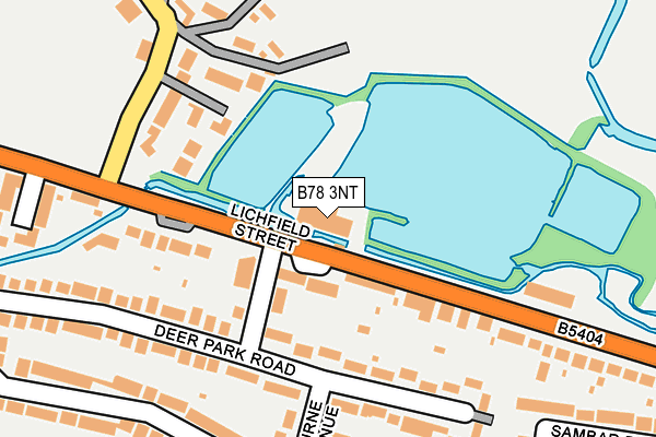
B78 3NT is located in the Fazeley electoral ward, within the local authority district of Lichfield and the English Parliamentary constituency of Tamworth. The Sub Integrated Care Board (ICB) Location is NHS Staffordshire and Stoke-on-Trent ICB - 05Q and the police force is Staffordshire. This postcode has been in use since June 1998.


GetTheData
Source: OS OpenMap – Local (Ordnance Survey)
Source: OS VectorMap District (Ordnance Survey)
Licence: Open Government Licence (requires attribution)
| Easting | 419512 |
| Northing | 302245 |
| Latitude | 52.617628 |
| Longitude | -1.713237 |
GetTheData
Source: Open Postcode Geo
Licence: Open Government Licence
| Country | England |
| Postcode District | B78 |
➜ See where B78 is on a map ➜ Where is Fazeley? | |
GetTheData
Source: Land Registry Price Paid Data
Licence: Open Government Licence
Elevation or altitude of B78 3NT as distance above sea level:
| Metres | Feet | |
|---|---|---|
| Elevation | 70m | 230ft |
Elevation is measured from the approximate centre of the postcode, to the nearest point on an OS contour line from OS Terrain 50, which has contour spacing of ten vertical metres.
➜ How high above sea level am I? Find the elevation of your current position using your device's GPS.
GetTheData
Source: Open Postcode Elevation
Licence: Open Government Licence
| Ward | Fazeley |
| Constituency | Tamworth |
GetTheData
Source: ONS Postcode Database
Licence: Open Government Licence
| Deer Park Road (Lichfield Road) | Bonehill | 71m |
| Deer Park Road (Lichfield Street) | Bonehill | 80m |
| Lakeside Industrial Park (A5 Lichfield Street) | Bonehill | 110m |
| Lakeside Industrial Park (A5 Lichfield Street) | Bonehill | 141m |
| Brewster Close (Lichfield Street) | Bonehill | 244m |
| Wilnecote (Staffs) Station | 2.4km |
| Tamworth Station | 2.9km |
| Tamworth High Level Station | 2.9km |
GetTheData
Source: NaPTAN
Licence: Open Government Licence
GetTheData
Source: ONS Postcode Database
Licence: Open Government Licence


➜ Get more ratings from the Food Standards Agency
GetTheData
Source: Food Standards Agency
Licence: FSA terms & conditions
| Last Collection | |||
|---|---|---|---|
| Location | Mon-Fri | Sat | Distance |
| Manor Road Mile Oak | 16:45 | 07:00 | 338m |
| Manor Drive / Fallow Road | 16:45 | 07:00 | 449m |
| Fazeley Post Office | 17:20 | 11:30 | 1,001m |
GetTheData
Source: Dracos
Licence: Creative Commons Attribution-ShareAlike
The below table lists the International Territorial Level (ITL) codes (formerly Nomenclature of Territorial Units for Statistics (NUTS) codes) and Local Administrative Units (LAU) codes for B78 3NT:
| ITL 1 Code | Name |
|---|---|
| TLG | West Midlands (England) |
| ITL 2 Code | Name |
| TLG2 | Shropshire and Staffordshire |
| ITL 3 Code | Name |
| TLG24 | Staffordshire CC |
| LAU 1 Code | Name |
| E07000194 | Lichfield |
GetTheData
Source: ONS Postcode Directory
Licence: Open Government Licence
The below table lists the Census Output Area (OA), Lower Layer Super Output Area (LSOA), and Middle Layer Super Output Area (MSOA) for B78 3NT:
| Code | Name | |
|---|---|---|
| OA | E00150322 | |
| LSOA | E01029503 | Lichfield 012C |
| MSOA | E02006157 | Lichfield 012 |
GetTheData
Source: ONS Postcode Directory
Licence: Open Government Licence
| B78 3SY | Deer Park Road | 146m |
| B78 3QF | Lichfield Street | 174m |
| B78 3QG | Lichfield Street | 180m |
| B78 3TB | Bourne Avenue | 198m |
| B78 3QQ | Lichfield Street | 200m |
| B78 3HY | Park Lane | 221m |
| B78 3SZ | Deer Park Road | 226m |
| B78 3SP | Reindeer Road | 251m |
| B78 3SW | Reindeer Road | 260m |
| B78 3HX | Park Lane | 270m |
GetTheData
Source: Open Postcode Geo; Land Registry Price Paid Data
Licence: Open Government Licence