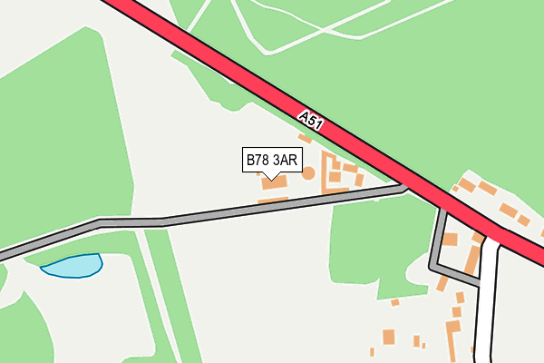
B78 3AR is located in the Bourne Vale electoral ward, within the local authority district of Lichfield and the English Parliamentary constituency of Tamworth. The Sub Integrated Care Board (ICB) Location is NHS Staffordshire and Stoke-on-Trent ICB - 05Q and the police force is Staffordshire. This postcode has been in use since January 1980.


GetTheData
Source: OS OpenMap – Local (Ordnance Survey)
Source: OS VectorMap District (Ordnance Survey)
Licence: Open Government Licence (requires attribution)
| Easting | 416774 |
| Northing | 305052 |
| Latitude | 52.642953 |
| Longitude | -1.753536 |
GetTheData
Source: Open Postcode Geo
Licence: Open Government Licence
| Country | England |
| Postcode District | B78 |
➜ See where B78 is on a map | |
GetTheData
Source: Land Registry Price Paid Data
Licence: Open Government Licence
Elevation or altitude of B78 3AR as distance above sea level:
| Metres | Feet | |
|---|---|---|
| Elevation | 120m | 394ft |
Elevation is measured from the approximate centre of the postcode, to the nearest point on an OS contour line from OS Terrain 50, which has contour spacing of ten vertical metres.
➜ How high above sea level am I? Find the elevation of your current position using your device's GPS.
GetTheData
Source: Open Postcode Elevation
Licence: Open Government Licence
| Ward | Bourne Vale |
| Constituency | Tamworth |
GetTheData
Source: ONS Postcode Database
Licence: Open Government Licence
| Riding School (Hopwas Hill) | Hopwas | 204m |
| Packington Lane (Hopwas Hill) | Hopwas | 214m |
| Packington Lane (Hopwas Hill) | Hopwas | 249m |
| Riding School (Hopwas Hill) | Hopwas | 315m |
| Plantation Lane (Hopwas Hill) | Hopwas | 655m |
| Tamworth Station | 4.6km |
| Tamworth High Level Station | 4.6km |
| Lichfield Trent Valley Station | 5.8km |
GetTheData
Source: NaPTAN
Licence: Open Government Licence
| Percentage of properties with Next Generation Access | 100.0% |
| Percentage of properties with Superfast Broadband | 100.0% |
| Percentage of properties with Ultrafast Broadband | 0.0% |
| Percentage of properties with Full Fibre Broadband | 0.0% |
Superfast Broadband is between 30Mbps and 300Mbps
Ultrafast Broadband is > 300Mbps
| Percentage of properties unable to receive 2Mbps | 0.0% |
| Percentage of properties unable to receive 5Mbps | 0.0% |
| Percentage of properties unable to receive 10Mbps | 0.0% |
| Percentage of properties unable to receive 30Mbps | 0.0% |
GetTheData
Source: Ofcom
Licence: Ofcom Terms of Use (requires attribution)
GetTheData
Source: ONS Postcode Database
Licence: Open Government Licence


➜ Get more ratings from the Food Standards Agency
GetTheData
Source: Food Standards Agency
Licence: FSA terms & conditions
| Last Collection | |||
|---|---|---|---|
| Location | Mon-Fri | Sat | Distance |
| Hopwas | 17:15 | 09:00 | 1,186m |
| Watling St Hints | 11:15 | 08:00 | 1,933m |
| Braham / Buckingham Road | 18:30 | 11:30 | 1,953m |
GetTheData
Source: Dracos
Licence: Creative Commons Attribution-ShareAlike
The below table lists the International Territorial Level (ITL) codes (formerly Nomenclature of Territorial Units for Statistics (NUTS) codes) and Local Administrative Units (LAU) codes for B78 3AR:
| ITL 1 Code | Name |
|---|---|
| TLG | West Midlands (England) |
| ITL 2 Code | Name |
| TLG2 | Shropshire and Staffordshire |
| ITL 3 Code | Name |
| TLG24 | Staffordshire CC |
| LAU 1 Code | Name |
| E07000194 | Lichfield |
GetTheData
Source: ONS Postcode Directory
Licence: Open Government Licence
The below table lists the Census Output Area (OA), Lower Layer Super Output Area (LSOA), and Middle Layer Super Output Area (MSOA) for B78 3AR:
| Code | Name | |
|---|---|---|
| OA | E00168394 | |
| LSOA | E01029488 | Lichfield 012A |
| MSOA | E02006157 | Lichfield 012 |
GetTheData
Source: ONS Postcode Directory
Licence: Open Government Licence
| B78 3AY | Packington Lane | 287m |
| B78 3AN | Lichfield Road | 422m |
| B78 3DU | Woodlands Close | 714m |
| B78 3AQ | Lichfield Road | 736m |
| B78 3AG | Lichfield Road | 785m |
| B78 3AL | Church Drive | 867m |
| B78 3AF | Lichfield Road | 982m |
| B78 3AJ | Lichfield Crescent | 984m |
| B78 3AS | Nursery Lane | 1042m |
| B78 3AD | School Lane | 1134m |
GetTheData
Source: Open Postcode Geo; Land Registry Price Paid Data
Licence: Open Government Licence