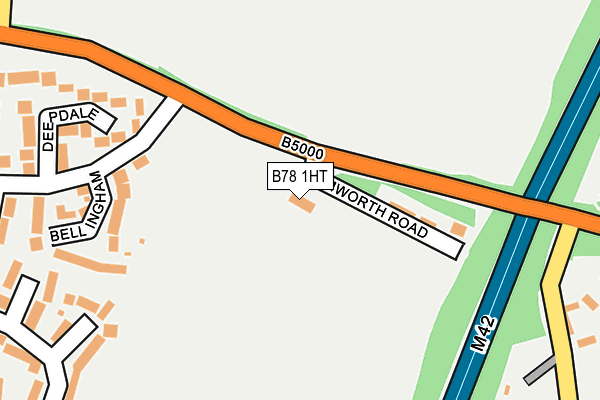
B78 1HT is located in the Polesworth West electoral ward, within the local authority district of North Warwickshire and the English Parliamentary constituency of North Warwickshire. The Sub Integrated Care Board (ICB) Location is NHS Coventry and Warwickshire ICB - B2M3M and the police force is Warwickshire. This postcode has been in use since January 1980.


GetTheData
Source: OS OpenMap – Local (Ordnance Survey)
Source: OS VectorMap District (Ordnance Survey)
Licence: Open Government Licence (requires attribution)
| Easting | 424868 |
| Northing | 302409 |
| Latitude | 52.618885 |
| Longitude | -1.634117 |
GetTheData
Source: Open Postcode Geo
Licence: Open Government Licence
| Country | England |
| Postcode District | B78 |
➜ See where B78 is on a map | |
GetTheData
Source: Land Registry Price Paid Data
Licence: Open Government Licence
Elevation or altitude of B78 1HT as distance above sea level:
| Metres | Feet | |
|---|---|---|
| Elevation | 110m | 361ft |
Elevation is measured from the approximate centre of the postcode, to the nearest point on an OS contour line from OS Terrain 50, which has contour spacing of ten vertical metres.
➜ How high above sea level am I? Find the elevation of your current position using your device's GPS.
GetTheData
Source: Open Postcode Elevation
Licence: Open Government Licence
| Ward | Polesworth West |
| Constituency | North Warwickshire |
GetTheData
Source: ONS Postcode Database
Licence: Open Government Licence
| Sports Ground (Tamworth Road) | Polesworth | 59m |
| Sports Ground (Tamworth Road) | Polesworth | 68m |
| Broadlee (Chiltern Rd) | Stonydelph | 275m |
| Broadlee (Chiltern Rd) | Stonydelph | 308m |
| Mendip Way (Chiltern Rd) | Stonydelph | 544m |
| Polesworth Station | 1.8km |
| Wilnecote (Staffs) Station | 3.2km |
| Tamworth High Level Station | 4.1km |
GetTheData
Source: NaPTAN
Licence: Open Government Licence
GetTheData
Source: ONS Postcode Database
Licence: Open Government Licence


➜ Get more ratings from the Food Standards Agency
GetTheData
Source: Food Standards Agency
Licence: FSA terms & conditions
| Last Collection | |||
|---|---|---|---|
| Location | Mon-Fri | Sat | Distance |
| Malham Road / Lowforce | 18:00 | 11:30 | 825m |
| Birchmoor Post Office | 17:00 | 10:30 | 1,017m |
| Granada Services | 17:30 | 11:00 | 1,344m |
GetTheData
Source: Dracos
Licence: Creative Commons Attribution-ShareAlike
The below table lists the International Territorial Level (ITL) codes (formerly Nomenclature of Territorial Units for Statistics (NUTS) codes) and Local Administrative Units (LAU) codes for B78 1HT:
| ITL 1 Code | Name |
|---|---|
| TLG | West Midlands (England) |
| ITL 2 Code | Name |
| TLG1 | Herefordshire, Worcestershire and Warwickshire |
| ITL 3 Code | Name |
| TLG13 | Warwickshire CC |
| LAU 1 Code | Name |
| E07000218 | North Warwickshire |
GetTheData
Source: ONS Postcode Directory
Licence: Open Government Licence
The below table lists the Census Output Area (OA), Lower Layer Super Output Area (LSOA), and Middle Layer Super Output Area (MSOA) for B78 1HT:
| Code | Name | |
|---|---|---|
| OA | E00158244 | |
| LSOA | E01031040 | North Warwickshire 001F |
| MSOA | E02006468 | North Warwickshire 001 |
GetTheData
Source: ONS Postcode Directory
Licence: Open Government Licence
| B78 1HU | Tamworth Road | 107m |
| B77 4PE | Bellingham | 217m |
| B77 4PD | Deepdale | 236m |
| B77 4PF | Broadlee | 296m |
| B77 4PB | Dovestone | 353m |
| B77 4PQ | Birdhope | 359m |
| B77 4PA | Deerhill | 423m |
| B77 4PG | Broadlee | 434m |
| B78 1AR | Robeys Lane | 471m |
| B77 4PY | Cromdale | 478m |
GetTheData
Source: Open Postcode Geo; Land Registry Price Paid Data
Licence: Open Government Licence