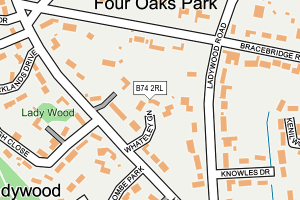
B74 2RL lies on Whateley Green in Sutton Coldfield. B74 2RL is located in the Sutton Four Oaks electoral ward, within the metropolitan district of Birmingham and the English Parliamentary constituency of Sutton Coldfield. The Sub Integrated Care Board (ICB) Location is NHS Birmingham and Solihull ICB - 15E and the police force is West Midlands. This postcode has been in use since September 1981.


GetTheData
Source: OS OpenMap – Local (Ordnance Survey)
Source: OS VectorMap District (Ordnance Survey)
Licence: Open Government Licence (requires attribution)
| Easting | 411066 |
| Northing | 297629 |
| Latitude | 52.576367 |
| Longitude | -1.838138 |
GetTheData
Source: Open Postcode Geo
Licence: Open Government Licence
| Street | Whateley Green |
| Town/City | Sutton Coldfield |
| Country | England |
| Postcode District | B74 |
➜ See where B74 is on a map ➜ Where is Royal Sutton Coldfield? | |
GetTheData
Source: Land Registry Price Paid Data
Licence: Open Government Licence
Elevation or altitude of B74 2RL as distance above sea level:
| Metres | Feet | |
|---|---|---|
| Elevation | 140m | 459ft |
Elevation is measured from the approximate centre of the postcode, to the nearest point on an OS contour line from OS Terrain 50, which has contour spacing of ten vertical metres.
➜ How high above sea level am I? Find the elevation of your current position using your device's GPS.
GetTheData
Source: Open Postcode Elevation
Licence: Open Government Licence
| Ward | Sutton Four Oaks |
| Constituency | Sutton Coldfield |
GetTheData
Source: ONS Postcode Database
Licence: Open Government Licence
2017 6 JAN £1,600,000 |
2008 27 OCT £1,150,000 |
15, WHATELEY GREEN, SUTTON COLDFIELD, B74 2RL 1999 17 NOV £387,500 |
➜ Royal Sutton Coldfield house prices
GetTheData
Source: HM Land Registry Price Paid Data
Licence: Contains HM Land Registry data © Crown copyright and database right 2025. This data is licensed under the Open Government Licence v3.0.
| Four Oaks Rail Stn (Lichfield Rd) | Four Oaks | 636m |
| Four Oaks Rail Stn (Lichfield Rd) | Four Oaks | 646m |
| Blackroot Rd (Lichfield Rd) | Doe Bank | 783m |
| Blackroot Rd (Lichfield Rd) | Doe Bank | 821m |
| Jordan Rd (Lichfield Rd) | Mere Green | 870m |
| Four Oaks Station | 0.8km |
| Sutton Coldfield Station | 1.6km |
| Butlers Lane Station | 1.8km |
GetTheData
Source: NaPTAN
Licence: Open Government Licence
| Percentage of properties with Next Generation Access | 100.0% |
| Percentage of properties with Superfast Broadband | 100.0% |
| Percentage of properties with Ultrafast Broadband | 0.0% |
| Percentage of properties with Full Fibre Broadband | 0.0% |
Superfast Broadband is between 30Mbps and 300Mbps
Ultrafast Broadband is > 300Mbps
| Percentage of properties unable to receive 2Mbps | 0.0% |
| Percentage of properties unable to receive 5Mbps | 0.0% |
| Percentage of properties unable to receive 10Mbps | 0.0% |
| Percentage of properties unable to receive 30Mbps | 0.0% |
GetTheData
Source: Ofcom
Licence: Ofcom Terms of Use (requires attribution)
GetTheData
Source: ONS Postcode Database
Licence: Open Government Licence


➜ Get more ratings from the Food Standards Agency
GetTheData
Source: Food Standards Agency
Licence: FSA terms & conditions
| Last Collection | |||
|---|---|---|---|
| Location | Mon-Fri | Sat | Distance |
| Hartopp Road / Bracebridge Road | 17:15 | 11:30 | 298m |
| Blackroot Road / Beaconsfield Road | 17:15 | 11:30 | 529m |
| Four Oaks Station | 17:15 | 11:30 | 638m |
GetTheData
Source: Dracos
Licence: Creative Commons Attribution-ShareAlike
The below table lists the International Territorial Level (ITL) codes (formerly Nomenclature of Territorial Units for Statistics (NUTS) codes) and Local Administrative Units (LAU) codes for B74 2RL:
| ITL 1 Code | Name |
|---|---|
| TLG | West Midlands (England) |
| ITL 2 Code | Name |
| TLG3 | West Midlands |
| ITL 3 Code | Name |
| TLG31 | Birmingham |
| LAU 1 Code | Name |
| E08000025 | Birmingham |
GetTheData
Source: ONS Postcode Directory
Licence: Open Government Licence
The below table lists the Census Output Area (OA), Lower Layer Super Output Area (LSOA), and Middle Layer Super Output Area (MSOA) for B74 2RL:
| Code | Name | |
|---|---|---|
| OA | E00047751 | |
| LSOA | E01009430 | Birmingham 004E |
| MSOA | E02001830 | Birmingham 004 |
GetTheData
Source: ONS Postcode Directory
Licence: Open Government Licence
| B74 2QR | Hartopp Road | 91m |
| B74 2SL | Bracebridge Road | 121m |
| B74 2QN | Ladywood Road | 172m |
| B74 2QX | Hartopp Road | 215m |
| B74 2QB | Coombe Park | 239m |
| B74 2QS | Stoneleigh Close | 242m |
| B74 2QL | Bracebridge Road | 258m |
| B74 2QW | Knowles Drive | 279m |
| B74 2QU | Parklands Drive | 281m |
| B74 2QY | Hartopp Road | 283m |
GetTheData
Source: Open Postcode Geo; Land Registry Price Paid Data
Licence: Open Government Licence