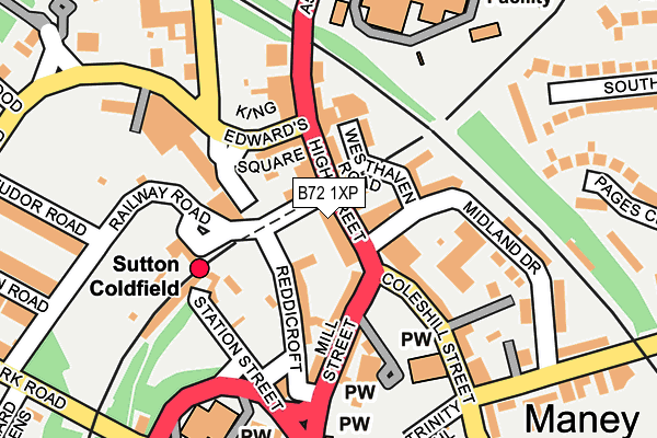
B72 1XP is located in the Sutton Trinity electoral ward, within the metropolitan district of Birmingham and the English Parliamentary constituency of Sutton Coldfield. The Sub Integrated Care Board (ICB) Location is NHS Birmingham and Solihull ICB - 15E and the police force is West Midlands. This postcode has been in use since January 1980.


GetTheData
Source: OS OpenMap – Local (Ordnance Survey)
Source: OS VectorMap District (Ordnance Survey)
Licence: Open Government Licence (requires attribution)
| Easting | 412100 |
| Northing | 296417 |
| Latitude | 52.565450 |
| Longitude | -1.822924 |
GetTheData
Source: Open Postcode Geo
Licence: Open Government Licence
| Country | England |
| Postcode District | B72 |
➜ See where B72 is on a map ➜ Where is Royal Sutton Coldfield? | |
GetTheData
Source: Land Registry Price Paid Data
Licence: Open Government Licence
Elevation or altitude of B72 1XP as distance above sea level:
| Metres | Feet | |
|---|---|---|
| Elevation | 130m | 427ft |
Elevation is measured from the approximate centre of the postcode, to the nearest point on an OS contour line from OS Terrain 50, which has contour spacing of ten vertical metres.
➜ How high above sea level am I? Find the elevation of your current position using your device's GPS.
GetTheData
Source: Open Postcode Elevation
Licence: Open Government Licence
| Ward | Sutton Trinity |
| Constituency | Sutton Coldfield |
GetTheData
Source: ONS Postcode Database
Licence: Open Government Licence
| Trinity Church (Mill St) | Sutton Coldfield | 76m |
| Trinity Church (Mill St) | Sutton Coldfield | 87m |
| Midland Drive (Rectory Rd) | Sutton Coldfield | 222m |
| Sutton Town Hall (Upper Clifton Rd) | Sutton Coldfield | 234m |
| Sutton Town Hall (Upper Clifton Rd) | Sutton Coldfield | 245m |
| Sutton Coldfield Station | 0.1km |
| Four Oaks Station | 1.6km |
| Wylde Green Station | 2.3km |
GetTheData
Source: NaPTAN
Licence: Open Government Licence
GetTheData
Source: ONS Postcode Database
Licence: Open Government Licence


➜ Get more ratings from the Food Standards Agency
GetTheData
Source: Food Standards Agency
Licence: FSA terms & conditions
| Last Collection | |||
|---|---|---|---|
| Location | Mon-Fri | Sat | Distance |
| Mill Street | 18:30 | 12:00 | 82m |
| 8 Mill Street | 18:30 | 12:00 | 91m |
| Mill Street | 18:30 | 91m | |
GetTheData
Source: Dracos
Licence: Creative Commons Attribution-ShareAlike
The below table lists the International Territorial Level (ITL) codes (formerly Nomenclature of Territorial Units for Statistics (NUTS) codes) and Local Administrative Units (LAU) codes for B72 1XP:
| ITL 1 Code | Name |
|---|---|
| TLG | West Midlands (England) |
| ITL 2 Code | Name |
| TLG3 | West Midlands |
| ITL 3 Code | Name |
| TLG31 | Birmingham |
| LAU 1 Code | Name |
| E08000025 | Birmingham |
GetTheData
Source: ONS Postcode Directory
Licence: Open Government Licence
The below table lists the Census Output Area (OA), Lower Layer Super Output Area (LSOA), and Middle Layer Super Output Area (MSOA) for B72 1XP:
| Code | Name | |
|---|---|---|
| OA | E00047879 | |
| LSOA | E01009449 | Birmingham 009A |
| MSOA | E02001835 | Birmingham 009 |
GetTheData
Source: ONS Postcode Directory
Licence: Open Government Licence
| B72 1UX | High Street | 34m |
| B72 1UU | Old Bank Place | 48m |
| B72 1UP | High Street | 60m |
| B72 1TU | Midland Drive | 119m |
| B72 1UQ | High Street | 129m |
| B72 1SD | Coleshill Street | 147m |
| B72 1UH | High Street | 150m |
| B72 1SQ | Church House Drive | 165m |
| B74 2PG | Anchorage Road | 205m |
| B73 6AL | Upper Clifton Road | 214m |
GetTheData
Source: Open Postcode Geo; Land Registry Price Paid Data
Licence: Open Government Licence