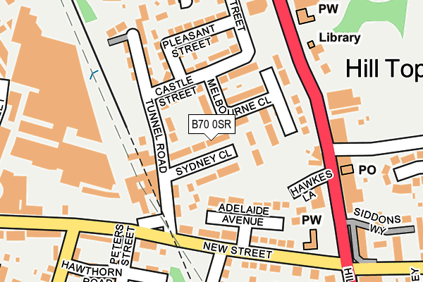
B70 0SR lies on Sydney Close in West Bromwich. B70 0SR is located in the Wednesbury South electoral ward, within the metropolitan district of Sandwell and the English Parliamentary constituency of West Bromwich West. The Sub Integrated Care Board (ICB) Location is NHS Black Country ICB - D2P2L and the police force is West Midlands. This postcode has been in use since January 1980.


GetTheData
Source: OS OpenMap – Local (Ordnance Survey)
Source: OS VectorMap District (Ordnance Survey)
Licence: Open Government Licence (requires attribution)
| Easting | 399146 |
| Northing | 293408 |
| Latitude | 52.538531 |
| Longitude | -2.014022 |
GetTheData
Source: Open Postcode Geo
Licence: Open Government Licence
| Street | Sydney Close |
| Town/City | West Bromwich |
| Country | England |
| Postcode District | B70 |
➜ See where B70 is on a map ➜ Where is West Bromwich? | |
GetTheData
Source: Land Registry Price Paid Data
Licence: Open Government Licence
Elevation or altitude of B70 0SR as distance above sea level:
| Metres | Feet | |
|---|---|---|
| Elevation | 160m | 525ft |
Elevation is measured from the approximate centre of the postcode, to the nearest point on an OS contour line from OS Terrain 50, which has contour spacing of ten vertical metres.
➜ How high above sea level am I? Find the elevation of your current position using your device's GPS.
GetTheData
Source: Open Postcode Elevation
Licence: Open Government Licence
| Ward | Wednesbury South |
| Constituency | West Bromwich West |
GetTheData
Source: ONS Postcode Database
Licence: Open Government Licence
| Dial Lane (Harvills Hawthorn) | Harvils Hawthorne | 166m |
| Dial Lane (Harvills Hawthorn) | Harvils Hawthorne | 174m |
| Hawkes Lane (Hill Top) | Hill Top | 175m |
| New St (Norbury Rd) | Hill Top | 176m |
| New St (Norbury Rd) | Hill Top | 178m |
| Black Lake (Midland Metro Stop) (Black Lake) | Black Lake | 917m |
| Wednesbury Great Western Street (Metro Stop) (Great Western St) | Wednesbury | 1,314m |
| Dudley Street Guns Village (Midland Metro Stop) (Dudley St) | Guns Village | 1,536m |
| Wednesbury Parkway (Midland Metro Stop) (Leabrook Rd) | Wednesbury | 1,658m |
| Dudley Port Station | 2.9km |
| Tame Bridge Parkway Station | 3km |
| Bescot Stadium Station | 3.1km |
GetTheData
Source: NaPTAN
Licence: Open Government Licence
| Percentage of properties with Next Generation Access | 100.0% |
| Percentage of properties with Superfast Broadband | 100.0% |
| Percentage of properties with Ultrafast Broadband | 100.0% |
| Percentage of properties with Full Fibre Broadband | 0.0% |
Superfast Broadband is between 30Mbps and 300Mbps
Ultrafast Broadband is > 300Mbps
| Median download speed | 55.0Mbps |
| Average download speed | 54.9Mbps |
| Maximum download speed | 150.00Mbps |
| Median upload speed | 10.0Mbps |
| Average upload speed | 9.8Mbps |
| Maximum upload speed | 20.00Mbps |
| Percentage of properties unable to receive 2Mbps | 0.0% |
| Percentage of properties unable to receive 5Mbps | 0.0% |
| Percentage of properties unable to receive 10Mbps | 0.0% |
| Percentage of properties unable to receive 30Mbps | 0.0% |
GetTheData
Source: Ofcom
Licence: Ofcom Terms of Use (requires attribution)
Estimated total energy consumption in B70 0SR by fuel type, 2015.
| Consumption (kWh) | 472,372 |
|---|---|
| Meter count | 36 |
| Mean (kWh/meter) | 13,121 |
| Median (kWh/meter) | 13,730 |
| Consumption (kWh) | 89,943 |
|---|---|
| Meter count | 33 |
| Mean (kWh/meter) | 2,726 |
| Median (kWh/meter) | 2,924 |
GetTheData
Source: Postcode level gas estimates: 2015 (experimental)
Source: Postcode level electricity estimates: 2015 (experimental)
Licence: Open Government Licence
GetTheData
Source: ONS Postcode Database
Licence: Open Government Licence


➜ Get more ratings from the Food Standards Agency
GetTheData
Source: Food Standards Agency
Licence: FSA terms & conditions
| Last Collection | |||
|---|---|---|---|
| Location | Mon-Fri | Sat | Distance |
| Tame Street | 17:45 | 12:00 | 525m |
| Shops Huntingdon Road | 17:15 | 12:00 | 568m |
| Crookhay Lane / Winchester Road | 17:15 | 12:00 | 680m |
GetTheData
Source: Dracos
Licence: Creative Commons Attribution-ShareAlike
The below table lists the International Territorial Level (ITL) codes (formerly Nomenclature of Territorial Units for Statistics (NUTS) codes) and Local Administrative Units (LAU) codes for B70 0SR:
| ITL 1 Code | Name |
|---|---|
| TLG | West Midlands (England) |
| ITL 2 Code | Name |
| TLG3 | West Midlands |
| ITL 3 Code | Name |
| TLG37 | Sandwell |
| LAU 1 Code | Name |
| E08000028 | Sandwell |
GetTheData
Source: ONS Postcode Directory
Licence: Open Government Licence
The below table lists the Census Output Area (OA), Lower Layer Super Output Area (LSOA), and Middle Layer Super Output Area (MSOA) for B70 0SR:
| Code | Name | |
|---|---|---|
| OA | E00051036 | |
| LSOA | E01010100 | Sandwell 013F |
| MSOA | E02002055 | Sandwell 013 |
GetTheData
Source: ONS Postcode Directory
Licence: Open Government Licence
| B70 0SP | Melbourne Close | 54m |
| B70 0RH | Tunnel Road | 60m |
| B70 0RQ | Castle Street | 77m |
| B70 0RL | Canberra Close | 82m |
| B70 0SL | Adelaide Avenue | 95m |
| B70 0RJ | Tunnel Road | 105m |
| B70 0RN | Castle Street | 108m |
| B70 0RG | Castle Street | 110m |
| B70 0RW | Castle Street | 119m |
| B70 0SH | Hill Top | 132m |
GetTheData
Source: Open Postcode Geo; Land Registry Price Paid Data
Licence: Open Government Licence